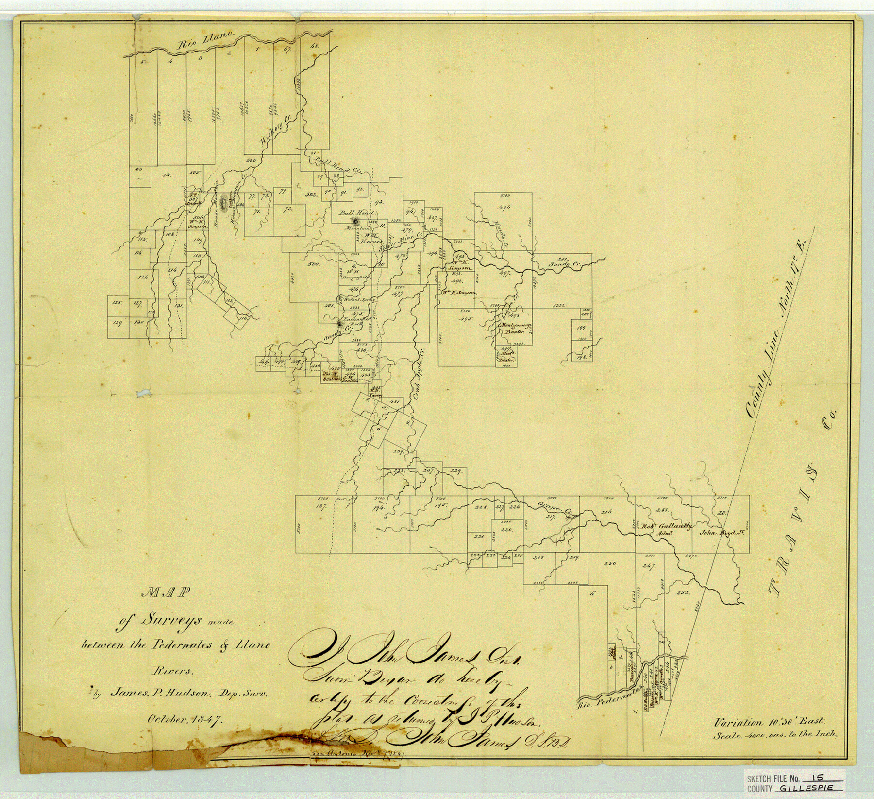
Gillespie County Sketch File 15
Map of Surveys made between the Pedernales & Llano Rivers
-
Map/Doc
11556
-
Collection
General Map Collection
-
Object Dates
1847 (Creation Date)
-
People and Organizations
James P. Hudson (Surveyor/Engineer)
-
Counties
Gillespie Llano Blanco
-
Subjects
Surveying Sketch File
-
Height x Width
17.7 x 19.3 inches
45.0 x 49.0 cm
-
Medium
paper, manuscript
-
Scale
1:4000
-
Features
Rio Llano
Hickory Creek
Bull Head Creek
House Mountain
House Mountain Creek
Bull Head Mountain
Silver Mine Creek
Hondo Creek
Sandy Creek
Legion Creek
Crab Apple Creek
Walnut Spring
Grape Creek
Rio Pedernales
Part of: General Map Collection
Dallas County Working Sketch 1

Print $20.00
- Digital $50.00
Dallas County Working Sketch 1
Size 41.4 x 28.3 inches
Map/Doc 68567
Galveston County Working Sketch 19

Print $20.00
- Digital $50.00
Galveston County Working Sketch 19
1983
Size 28.7 x 38.6 inches
Map/Doc 69356
Brazos River, Jones Bridge Special Map Sheet

Print $4.00
- Digital $50.00
Brazos River, Jones Bridge Special Map Sheet
1936
Size 29.8 x 28.2 inches
Map/Doc 65280
Map of Espiritu Santo Bay in Calhoun County showing subdivision therof for mineral development

Print $20.00
- Digital $50.00
Map of Espiritu Santo Bay in Calhoun County showing subdivision therof for mineral development
1938
Size 38.6 x 42.9 inches
Map/Doc 2499
Flight Mission No. DQN-6K, Frame 92, Calhoun County

Print $20.00
- Digital $50.00
Flight Mission No. DQN-6K, Frame 92, Calhoun County
1953
Size 18.6 x 22.3 inches
Map/Doc 84452
Donley County Boundary File 4

Print $10.00
- Digital $50.00
Donley County Boundary File 4
Size 5.7 x 8.4 inches
Map/Doc 52630
Nueces County NRC Article 33.136 Sketch 16

Print $68.00
- Digital $50.00
Nueces County NRC Article 33.136 Sketch 16
2012
Size 22.0 x 17.0 inches
Map/Doc 94804
Bexar County Working Sketch 10

Print $20.00
- Digital $50.00
Bexar County Working Sketch 10
1959
Size 22.6 x 34.5 inches
Map/Doc 67326
Erath County Sketch File A2

Print $20.00
- Digital $50.00
Erath County Sketch File A2
Size 15.9 x 19.5 inches
Map/Doc 11464
Intracoastal Waterway in Texas - Corpus Christi to Point Isabel including Arroyo Colorado to Mo. Pac. R.R. Bridge Near Harlingen

Print $20.00
- Digital $50.00
Intracoastal Waterway in Texas - Corpus Christi to Point Isabel including Arroyo Colorado to Mo. Pac. R.R. Bridge Near Harlingen
1933
Size 28.2 x 41.0 inches
Map/Doc 61853
Reconnaissance of Aransas Pass, Texas

Print $20.00
- Digital $50.00
Reconnaissance of Aransas Pass, Texas
1852
Size 14.4 x 13.6 inches
Map/Doc 76171
Fractional Township No. 8 South Range No. 2 West of the Indian Meridian, Indian Territory

Print $20.00
- Digital $50.00
Fractional Township No. 8 South Range No. 2 West of the Indian Meridian, Indian Territory
1898
Size 19.2 x 24.4 inches
Map/Doc 75196
You may also like
Flight Mission No. BRE-1P, Frame 75, Nueces County

Print $20.00
- Digital $50.00
Flight Mission No. BRE-1P, Frame 75, Nueces County
1956
Size 18.4 x 22.2 inches
Map/Doc 86657
Roberts County Working Sketch 47

Print $20.00
- Digital $50.00
Roberts County Working Sketch 47
1996
Size 19.6 x 34.7 inches
Map/Doc 63573
[Portion of Harrison County]
![78366, [Portion of Harrison County], General Map Collection](https://historictexasmaps.com/wmedia_w700/maps/78366.tif.jpg)
Print $3.00
- Digital $50.00
[Portion of Harrison County]
1841
Size 15.7 x 11.6 inches
Map/Doc 78366
Flight Mission No. BRE-1P, Frame 50, Nueces County

Print $20.00
- Digital $50.00
Flight Mission No. BRE-1P, Frame 50, Nueces County
1956
Size 18.5 x 22.3 inches
Map/Doc 86639
Andrews County Working Sketch 15

Print $40.00
- Digital $50.00
Andrews County Working Sketch 15
1957
Size 50.5 x 36.1 inches
Map/Doc 67061
Briscoe County Boundary File 3

Print $4.00
- Digital $50.00
Briscoe County Boundary File 3
Size 13.9 x 8.5 inches
Map/Doc 50778
Garza County Working Sketch 7

Print $20.00
- Digital $50.00
Garza County Working Sketch 7
1949
Size 26.0 x 28.2 inches
Map/Doc 63154
Travis County

Print $40.00
- Digital $50.00
Travis County
1936
Size 43.2 x 54.6 inches
Map/Doc 63078
Etats-Unis de l'Amérique Septentrionale avec les Isles Royale, de Terre Neuve de St. Jean, L'Acadie &c.

Print $20.00
- Digital $50.00
Etats-Unis de l'Amérique Septentrionale avec les Isles Royale, de Terre Neuve de St. Jean, L'Acadie &c.
1785
Size 20.9 x 28.2 inches
Map/Doc 93679
Map Showing Corrections for Capitol Leagues in Conflict in Oldham Co.

Print $40.00
- Digital $50.00
Map Showing Corrections for Capitol Leagues in Conflict in Oldham Co.
Size 53.0 x 32.4 inches
Map/Doc 89798
General Highway Map, Jefferson County, Texas

Print $20.00
General Highway Map, Jefferson County, Texas
1940
Size 24.8 x 18.6 inches
Map/Doc 79144
[Galveston, Harrisburg & San Antonio Railroad from Cuero to Stockdale]
![64184, [Galveston, Harrisburg & San Antonio Railroad from Cuero to Stockdale], General Map Collection](https://historictexasmaps.com/wmedia_w700/maps/64184.tif.jpg)
Print $20.00
- Digital $50.00
[Galveston, Harrisburg & San Antonio Railroad from Cuero to Stockdale]
1906
Size 14.1 x 34.2 inches
Map/Doc 64184