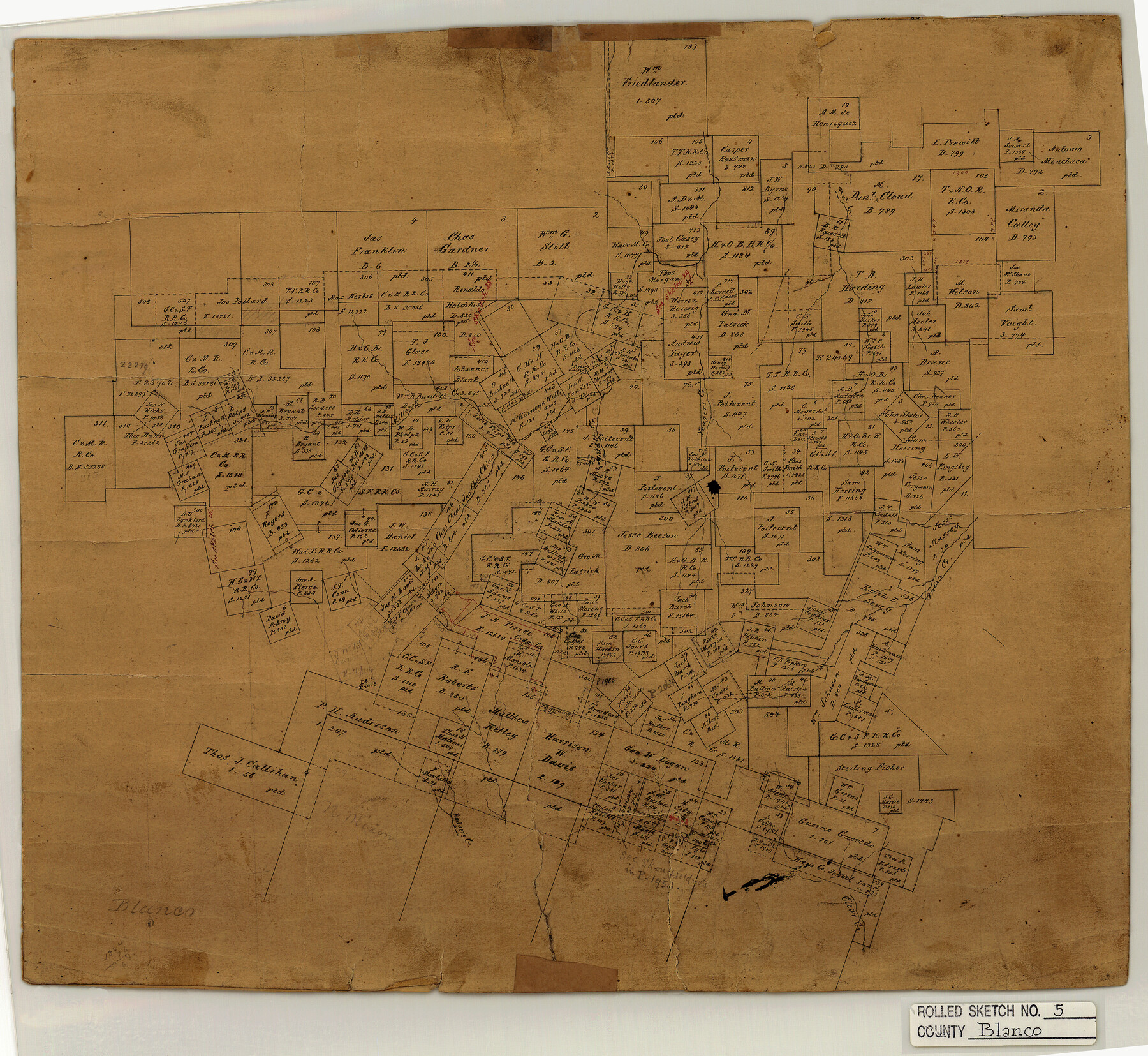
Blanco County Rolled Sketch 5
[Sketch in east part of Blanco Co.]
-
Map/Doc
5143
-
Collection
General Map Collection
-
Counties
Blanco
-
Subjects
Surveying Rolled Sketch
-
Height x Width
15.6 x 17.0 inches
39.6 x 43.2 cm
-
Medium
paper, manuscript
Part of: General Map Collection
Midland County Sketch File 7

Print $20.00
- Digital $50.00
Midland County Sketch File 7
1930
Size 33.1 x 23.7 inches
Map/Doc 12083
Refugio County Sketch File 10

Print $4.00
- Digital $50.00
Refugio County Sketch File 10
Size 8.2 x 9.4 inches
Map/Doc 35258
Guadalupe County

Print $20.00
- Digital $50.00
Guadalupe County
1872
Size 24.6 x 23.7 inches
Map/Doc 3610
Flight Mission No. BQY-4M, Frame 36, Harris County

Print $20.00
- Digital $50.00
Flight Mission No. BQY-4M, Frame 36, Harris County
1953
Size 18.6 x 22.3 inches
Map/Doc 85251
Ector County Working Sketch 22

Print $20.00
- Digital $50.00
Ector County Working Sketch 22
1959
Size 24.2 x 36.6 inches
Map/Doc 68865
DeWitt County Sketch File 8

Print $4.00
- Digital $50.00
DeWitt County Sketch File 8
1876
Size 8.5 x 5.2 inches
Map/Doc 20818
Hudspeth County Sketch File 50

Print $20.00
- Digital $50.00
Hudspeth County Sketch File 50
Size 11.2 x 8.7 inches
Map/Doc 42948
Pressler's Map of the State of Texas

Print $40.00
- Digital $50.00
Pressler's Map of the State of Texas
1858
Size 47.6 x 51.9 inches
Map/Doc 709
Hemphill County Working Sketch 19

Print $20.00
- Digital $50.00
Hemphill County Working Sketch 19
1972
Size 35.8 x 42.6 inches
Map/Doc 66114
Palo Pinto County Working Sketch 26

Print $20.00
- Digital $50.00
Palo Pinto County Working Sketch 26
1993
Map/Doc 71409
Culberson County Rolled Sketch 68

Print $20.00
- Digital $50.00
Culberson County Rolled Sketch 68
1997
Size 32.0 x 32.9 inches
Map/Doc 76402
Sketch of surveys made by Erath and Green in August 1846 on the waters of the Bosque River

Print $2.00
- Digital $50.00
Sketch of surveys made by Erath and Green in August 1846 on the waters of the Bosque River
1846
Size 10.6 x 7.8 inches
Map/Doc 303
You may also like
Rusk County Working Sketch 21

Print $20.00
- Digital $50.00
Rusk County Working Sketch 21
1953
Size 27.6 x 28.3 inches
Map/Doc 63657
Kleberg County Rolled Sketch 10-10

Print $20.00
- Digital $50.00
Kleberg County Rolled Sketch 10-10
1951
Size 38.7 x 32.7 inches
Map/Doc 9389
Map of Hays County, Texas

Print $20.00
- Digital $50.00
Map of Hays County, Texas
1880
Size 41.8 x 35.8 inches
Map/Doc 16848
Sketch of surveys in Dimmit, Maverick and Webb Cos.

Print $20.00
- Digital $50.00
Sketch of surveys in Dimmit, Maverick and Webb Cos.
1876
Size 17.9 x 14.7 inches
Map/Doc 5050
Plan of Brooklyn

Print $20.00
- Digital $50.00
Plan of Brooklyn
1909
Size 42.7 x 31.5 inches
Map/Doc 2192
Runnels County Sketch File H

Print $4.00
Runnels County Sketch File H
1890
Size 14.3 x 8.8 inches
Map/Doc 35450
Schleicher County Sketch File 27

Print $20.00
- Digital $50.00
Schleicher County Sketch File 27
Size 23.0 x 19.2 inches
Map/Doc 12305
Galveston to Rio Grande

Print $20.00
- Digital $50.00
Galveston to Rio Grande
1946
Size 44.6 x 36.6 inches
Map/Doc 69952
Maps of Gulf Intracoastal Waterway, Texas - Sabine River to the Rio Grande and connecting waterways including ship channels

Print $20.00
- Digital $50.00
Maps of Gulf Intracoastal Waterway, Texas - Sabine River to the Rio Grande and connecting waterways including ship channels
1966
Size 15.7 x 22.0 inches
Map/Doc 61983
Matagorda County NRC Article 33.136 Location Key Sheet

Print $20.00
- Digital $50.00
Matagorda County NRC Article 33.136 Location Key Sheet
1973
Size 27.0 x 23.0 inches
Map/Doc 88833
Flight Mission No. CGN-3P, Frame 24, San Patricio County

Print $20.00
- Digital $50.00
Flight Mission No. CGN-3P, Frame 24, San Patricio County
1956
Size 18.5 x 22.3 inches
Map/Doc 86982
Cherokee County Sketch File 3

Print $4.00
- Digital $50.00
Cherokee County Sketch File 3
1849
Size 7.5 x 11.0 inches
Map/Doc 18115