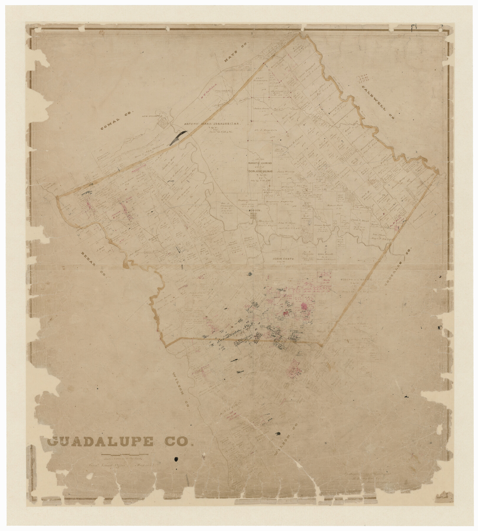
Guadalupe County
-
Map/Doc
3610
-
Collection
General Map Collection
-
Object Dates
1872 (Creation Date)
-
People and Organizations
Texas General Land Office (Publisher)
Herman Lungkwitz (Draftsman)
-
Counties
Guadalupe
-
Subjects
County
-
Height x Width
24.6 x 23.7 inches
62.5 x 60.2 cm
-
Features
Menchaca Creek
Cleto Creek
Castleman's Creek
Cibolo River
Elm Creek
Seguin Road
Gonzales Road
Cottonwood Creek
Mill Road
Nash Creek
Mill Creek
Guadalupe River
Seguin
San Marcos River
Santa Clara Creek
Nacogdoches Road
San Antonio Road
San Antonio and Nacogdoches Road
Comal Creek
Comal River
New Braunfels
Highsmith's Creek
York's Creek
Panete Creek
Mesquete Creek
Waterhole Creek
Part of: General Map Collection
Hays County Sketch File 8

Print $4.00
- Digital $50.00
Hays County Sketch File 8
1848
Size 5.5 x 7.8 inches
Map/Doc 26210
Greer County Sketch File 7

Print $40.00
- Digital $50.00
Greer County Sketch File 7
Size 12.8 x 17.5 inches
Map/Doc 24526
[Abstract Numbering Register - Kaufman through Reagan]
![82967, [Abstract Numbering Register - Kaufman through Reagan], General Map Collection](https://historictexasmaps.com/wmedia_w700/pdf_converted_jpg/qi_pdf_thumbnail_30614.jpg)
[Abstract Numbering Register - Kaufman through Reagan]
Map/Doc 82967
Titus County Sketch File 2

Print $4.00
- Digital $50.00
Titus County Sketch File 2
Size 8.2 x 10.1 inches
Map/Doc 38132
Kerr County Rolled Sketch 11A

Print $20.00
- Digital $50.00
Kerr County Rolled Sketch 11A
1950
Size 27.8 x 36.0 inches
Map/Doc 6496
Ward County Boundary File 1

Print $12.00
- Digital $50.00
Ward County Boundary File 1
Size 14.4 x 9.0 inches
Map/Doc 59667
Concho County Sketch File 10

Print $20.00
- Digital $50.00
Concho County Sketch File 10
1887
Size 23.1 x 33.8 inches
Map/Doc 11150
Crockett County Working Sketch 50

Print $20.00
- Digital $50.00
Crockett County Working Sketch 50
1940
Size 30.3 x 24.9 inches
Map/Doc 68383
Grayson County Working Sketch 26

Print $20.00
- Digital $50.00
Grayson County Working Sketch 26
1984
Size 27.7 x 38.8 inches
Map/Doc 63265
Exploration of the Red River of Louisiana in the the year 1852 by Randolph B. Marcy, Captain Fifth Infantry U.S. Army; assisted by George B. McClellan, Brevet Captain U.S. Engineers

Exploration of the Red River of Louisiana in the the year 1852 by Randolph B. Marcy, Captain Fifth Infantry U.S. Army; assisted by George B. McClellan, Brevet Captain U.S. Engineers
Size 9.5 x 11.7 inches
Map/Doc 95321
Webb County Working Sketch 20

Print $20.00
- Digital $50.00
Webb County Working Sketch 20
1925
Size 22.3 x 20.2 inches
Map/Doc 72385
Crockett County Sketch File 75a

Print $6.00
- Digital $50.00
Crockett County Sketch File 75a
Size 14.2 x 8.8 inches
Map/Doc 19873
You may also like
Colorado County Working Sketch 9

Print $20.00
- Digital $50.00
Colorado County Working Sketch 9
1939
Size 12.0 x 15.7 inches
Map/Doc 68109
Navarro County Working Sketch 5

Print $20.00
- Digital $50.00
Navarro County Working Sketch 5
1947
Size 30.3 x 33.2 inches
Map/Doc 71235
Tyler County Working Sketch 16

Print $20.00
- Digital $50.00
Tyler County Working Sketch 16
1960
Size 46.0 x 41.8 inches
Map/Doc 69486
Rusk County Sketch File 26

Print $20.00
Rusk County Sketch File 26
1932
Size 38.1 x 22.6 inches
Map/Doc 10595
[Surveys in the Jefferson District]
![69726, [Surveys in the Jefferson District], General Map Collection](https://historictexasmaps.com/wmedia_w700/maps/69726-1.tif.jpg)
Print $20.00
- Digital $50.00
[Surveys in the Jefferson District]
1841
Size 14.6 x 21.2 inches
Map/Doc 69726

Flight Mission No. DAG-24K, Frame 146, Matagorda County

Print $20.00
- Digital $50.00
Flight Mission No. DAG-24K, Frame 146, Matagorda County
1953
Size 18.6 x 22.2 inches
Map/Doc 86560
C. A. Pierce's Subdivision of Dick Slaughter Land

Print $20.00
- Digital $50.00
C. A. Pierce's Subdivision of Dick Slaughter Land
Size 37.7 x 17.1 inches
Map/Doc 90301
Rains County Working Sketch 10

Print $20.00
- Digital $50.00
Rains County Working Sketch 10
1998
Size 36.1 x 34.7 inches
Map/Doc 71836
[Surveys along the Nacogdoches River, Richland Creek, and the Trinity River]
![85, [Surveys along the Nacogdoches River, Richland Creek, and the Trinity River], General Map Collection](https://historictexasmaps.com/wmedia_w700/maps/85.tif.jpg)
Print $20.00
- Digital $50.00
[Surveys along the Nacogdoches River, Richland Creek, and the Trinity River]
1840
Size 24.2 x 17.9 inches
Map/Doc 85
Crockett County Working Sketch 99

Print $20.00
- Digital $50.00
Crockett County Working Sketch 99
1980
Size 37.1 x 34.5 inches
Map/Doc 68432
Matagorda County Aerial Photograph Index Sheet 6

Print $20.00
- Digital $50.00
Matagorda County Aerial Photograph Index Sheet 6
1953
Size 23.8 x 19.6 inches
Map/Doc 83727