Hudspeth County Sketch File 50
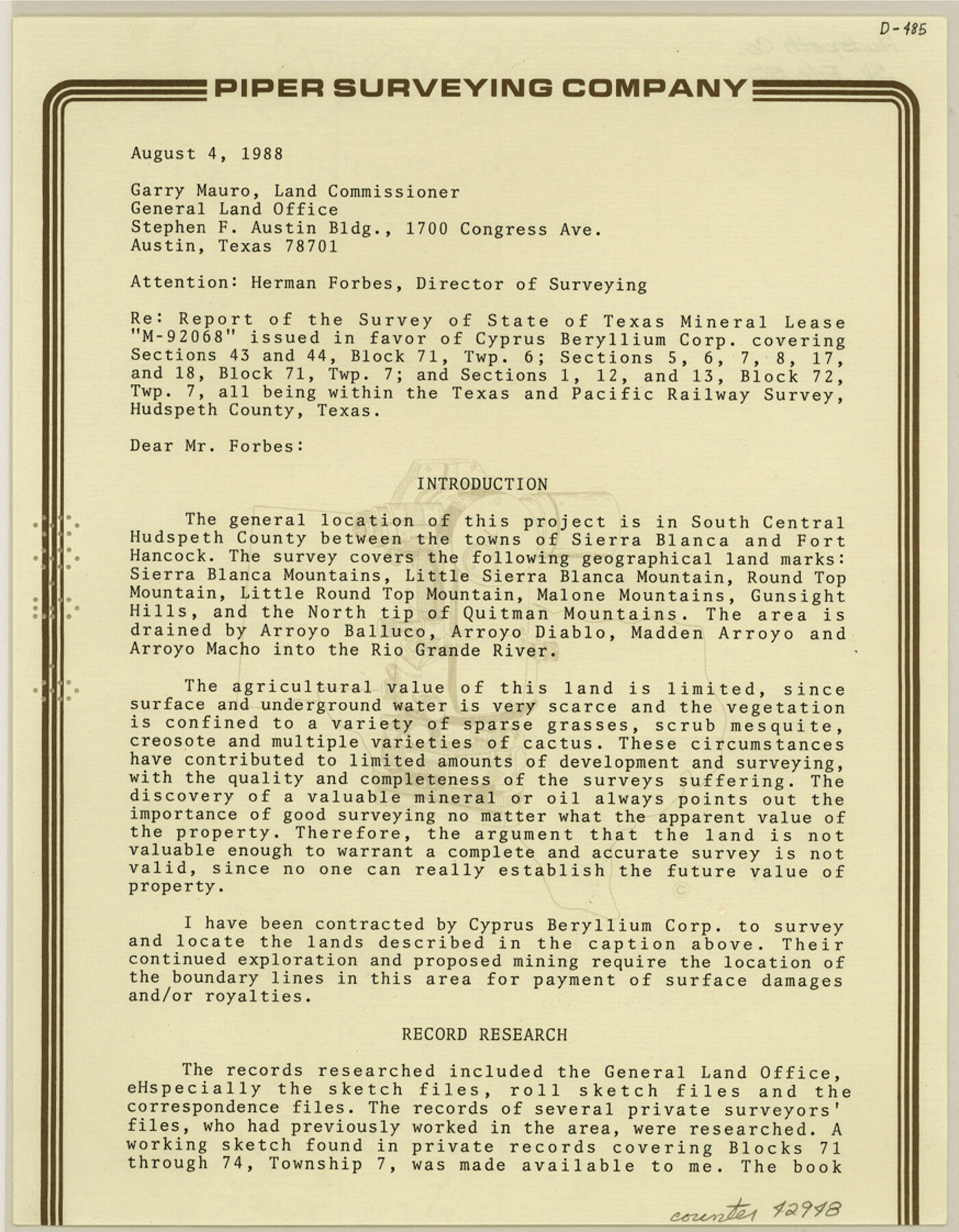
[Report of survey of Mineral Lease M-92068, covering sections 43 and 44, Block 71, Township 6, sections 5, 6, 7, 8, 17 and 18, Block 71, Township 7 and sections 1, 12, and 13, Block 72, Township 7]
-
Map/Doc
42948
-
Collection
General Map Collection
-
Object Dates
8/5/1988 (File Date)
8/4/1988 (Correspondence Date)
8/31/1878 (Survey Date)
10/3/1878 (Survey Date)
4/3/1879 (Survey Date)
1930 (Survey Date)
1938 (Survey Date)
7/14/1988 (Survey Date)
-
People and Organizations
J. Stan Piper (Surveyor/Engineer)
Jacob Kuechler (Surveyor/Engineer)
A.Q. Wingo (Surveyor/Engineer)
W.C. Walsh (GLO Commissioner)
Paul McCombs (Surveyor/Engineer)
A.H. Parker (Surveyor/Engineer)
W.J. Powell (Surveyor/Engineer)
R.W. Baker (Surveyor/Engineer)
W.C. Wilson (Surveyor/Engineer)
-
Counties
Hudspeth
-
Subjects
Surveying Sketch File
-
Height x Width
11.2 x 8.7 inches
28.5 x 22.1 cm
-
Medium
paper, print
-
Comments
See Hudspeth County Rolled Sketch 65 (9229) for sketch.
-
Features
Sierra Blanca
Fort Hancock
Sierra Blanca Mountains
Little Sierra Blanca Mountain
Round Top Mountain
Little Round Top Mountain
Malone Mountains
Gunsight Hills
Quitman Mountains
Arroyo Balluco
Arroyo Diablo
Madden Arroyo
Arroyo Macho
T&P
El Paso
Pecos River
Related maps
Hudspeth County Rolled Sketch 65

Print $40.00
- Digital $50.00
Hudspeth County Rolled Sketch 65
1988
Size 70.5 x 37.7 inches
Map/Doc 9229
Part of: General Map Collection
Brewster County Sketch File FN-34

Print $40.00
- Digital $50.00
Brewster County Sketch File FN-34
1943
Size 23.1 x 27.1 inches
Map/Doc 10984

[Sketch for Mineral Application 26649-26650 - Sabine River, Harry A. Wolan]
![65566, [Sketch for Mineral Application 26649-26650 - Sabine River, Harry A. Wolan], General Map Collection](https://historictexasmaps.com/wmedia_w700/maps/65566.tif.jpg)
Print $40.00
- Digital $50.00
[Sketch for Mineral Application 26649-26650 - Sabine River, Harry A. Wolan]
Size 72.0 x 36.9 inches
Map/Doc 65566
Sabine County Sketch File 11

Print $4.00
Sabine County Sketch File 11
Size 6.2 x 8.3 inches
Map/Doc 35629
Martin County Working Sketch 8

Print $40.00
- Digital $50.00
Martin County Working Sketch 8
1971
Size 53.1 x 36.8 inches
Map/Doc 70826
Pecos County Rolled Sketch 61

Print $20.00
- Digital $50.00
Pecos County Rolled Sketch 61
1925
Size 26.5 x 25.5 inches
Map/Doc 7233
Jeff Davis County Boundary File 1a

Print $8.00
- Digital $50.00
Jeff Davis County Boundary File 1a
Size 14.3 x 8.8 inches
Map/Doc 55501
Pecos County Sketch File 20

Print $20.00
- Digital $50.00
Pecos County Sketch File 20
Size 25.9 x 12.0 inches
Map/Doc 12160
Stephens County Working Sketch 41

Print $40.00
- Digital $50.00
Stephens County Working Sketch 41
2008
Size 34.1 x 48.0 inches
Map/Doc 88737
Freestone County Working Sketch 16

Print $20.00
- Digital $50.00
Freestone County Working Sketch 16
1980
Size 47.1 x 39.7 inches
Map/Doc 69258
Knox County Sketch File 1-1a

Print $30.00
- Digital $50.00
Knox County Sketch File 1-1a
1872
Size 8.2 x 12.4 inches
Map/Doc 29212
Panola County Working Sketch 27

Print $20.00
- Digital $50.00
Panola County Working Sketch 27
1956
Map/Doc 71436
You may also like
Atascosa County

Print $20.00
- Digital $50.00
Atascosa County
1948
Size 47.2 x 46.3 inches
Map/Doc 95421
Pecos County Rolled Sketch 188

Print $40.00
- Digital $50.00
Pecos County Rolled Sketch 188
1984
Size 59.4 x 43.5 inches
Map/Doc 9753
General tafel begreifend der gantzen undern weldt beschrenbung

Print $20.00
- Digital $50.00
General tafel begreifend der gantzen undern weldt beschrenbung
1545
Size 11.3 x 14.7 inches
Map/Doc 96566

Coryell County

Print $20.00
- Digital $50.00
Coryell County
1936
Size 45.4 x 41.4 inches
Map/Doc 95466
Galveston County Sketch File 31

Print $20.00
- Digital $50.00
Galveston County Sketch File 31
1916
Size 23.7 x 13.6 inches
Map/Doc 11534
Kerr County Working Sketch 13

Print $20.00
- Digital $50.00
Kerr County Working Sketch 13
1951
Size 24.3 x 22.3 inches
Map/Doc 70044
Loving County Boundary File 1

Print $6.00
- Digital $50.00
Loving County Boundary File 1
Size 11.2 x 8.7 inches
Map/Doc 56452
Flight Mission No. BRE-1P, Frame 9, Nueces County

Print $20.00
- Digital $50.00
Flight Mission No. BRE-1P, Frame 9, Nueces County
1956
Size 18.5 x 22.4 inches
Map/Doc 86617
Nolan County Working Sketch 2

Print $20.00
- Digital $50.00
Nolan County Working Sketch 2
1943
Size 26.7 x 25.0 inches
Map/Doc 71293
[League 27, Montgomery County School Land, William Tubbs Survey]
![91127, [League 27, Montgomery County School Land, William Tubbs Survey], Twichell Survey Records](https://historictexasmaps.com/wmedia_w700/maps/91127-1.tif.jpg)
Print $2.00
- Digital $50.00
[League 27, Montgomery County School Land, William Tubbs Survey]
Size 11.7 x 8.9 inches
Map/Doc 91127
Foard County Aerial Photograph Index Sheet 3

Print $20.00
- Digital $50.00
Foard County Aerial Photograph Index Sheet 3
1950
Size 20.3 x 18.9 inches
Map/Doc 83690