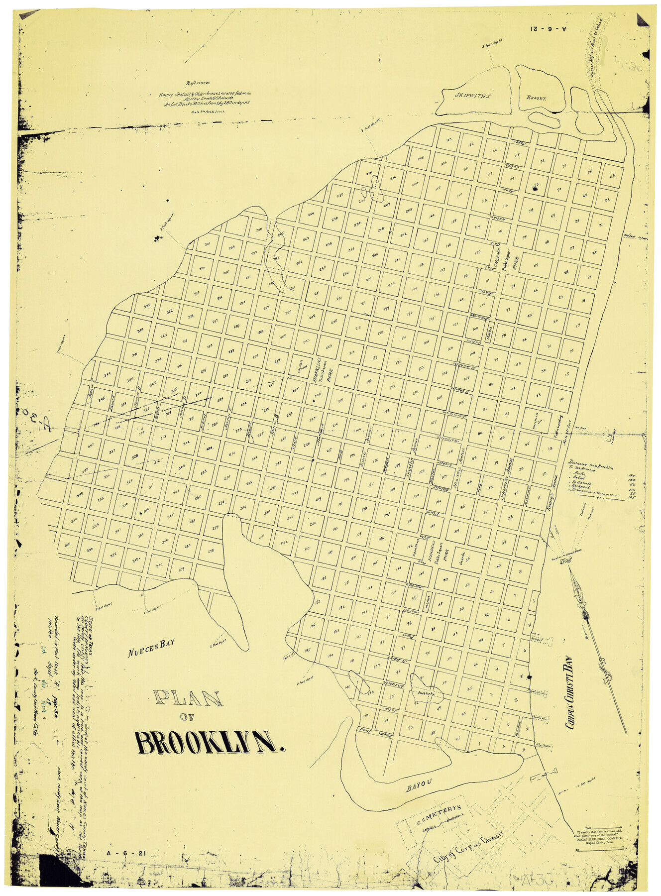
Plan of Brooklyn
A-6-21
-
Map/Doc
2192
-
Collection
General Map Collection
-
Object Dates
11/6/1909 (Creation Date)
-
People and Organizations
Nixon Blueprint Company (Printer)
-
Counties
Nueces
-
Subjects
City
-
Height x Width
42.7 x 31.5 inches
108.5 x 80.0 cm
-
Medium
blueprint/diazo
-
Scale
1" = 300 ft.
-
Features
Kings Wharf
Brooklyn
[Road to] Rockport
[Road to] Indianola
[Road to] Goliad
[Road to] Austin
[Road to] San Antonio
Corpus Christi
Protestant Cemetery
Catholic Cemetery
Oyster Reef
Skipwiths Wharf
Salt Lake
Doddridges Wharf
Corpus Christi Bay
Nueces Bay
Headens Park
Franklin's Park
Ohler's Park
Road to Goliad
Part of: General Map Collection
Bailey County

Print $40.00
- Digital $50.00
Bailey County
1956
Size 48.8 x 31.5 inches
Map/Doc 73074
Flight Mission No. DCL-7C, Frame 7, Kenedy County

Print $20.00
- Digital $50.00
Flight Mission No. DCL-7C, Frame 7, Kenedy County
1943
Size 15.3 x 15.2 inches
Map/Doc 85999
Flight Mission No. BRE-1P, Frame 26, Nueces County

Print $20.00
- Digital $50.00
Flight Mission No. BRE-1P, Frame 26, Nueces County
1956
Size 18.6 x 22.5 inches
Map/Doc 86621
Nueces County Rolled Sketch 96

Print $44.00
Nueces County Rolled Sketch 96
1983
Size 24.2 x 36.5 inches
Map/Doc 7053
Flight Mission No. DQO-2K, Frame 133, Galveston County

Print $20.00
- Digital $50.00
Flight Mission No. DQO-2K, Frame 133, Galveston County
1952
Size 18.7 x 22.5 inches
Map/Doc 85030
Flight Mission No. CUG-3P, Frame 21, Kleberg County

Print $20.00
- Digital $50.00
Flight Mission No. CUG-3P, Frame 21, Kleberg County
1956
Size 18.6 x 22.2 inches
Map/Doc 86231
Galveston County Sketch File 59

Print $8.00
- Digital $50.00
Galveston County Sketch File 59
1977
Size 14.2 x 8.7 inches
Map/Doc 23607
Liberty County Working Sketch 85

Print $20.00
- Digital $50.00
Liberty County Working Sketch 85
1987
Size 27.2 x 28.3 inches
Map/Doc 70545
University Lands Blocks 29-33, Crockett County, Texas

Print $20.00
- Digital $50.00
University Lands Blocks 29-33, Crockett County, Texas
1936
Size 29.8 x 42.7 inches
Map/Doc 2443

Webb County Rolled Sketch 56

Print $20.00
- Digital $50.00
Webb County Rolled Sketch 56
1945
Size 22.2 x 23.7 inches
Map/Doc 8208
Terrell County Sketch File 42

Print $20.00
- Digital $50.00
Terrell County Sketch File 42
1885
Map/Doc 97199
You may also like
[Blocks M13, S1, C3, JK3, and JK]
![90700, [Blocks M13, S1, C3, JK3, and JK], Twichell Survey Records](https://historictexasmaps.com/wmedia_w700/maps/90700-1.tif.jpg)
Print $20.00
- Digital $50.00
[Blocks M13, S1, C3, JK3, and JK]
Size 26.9 x 15.4 inches
Map/Doc 90700
Kimble County Working Sketch 28

Print $20.00
- Digital $50.00
Kimble County Working Sketch 28
1938
Size 29.4 x 23.2 inches
Map/Doc 70096
Loving County Rolled Sketch 3

Print $40.00
- Digital $50.00
Loving County Rolled Sketch 3
Size 13.9 x 145.3 inches
Map/Doc 9464

Polk County Sketch File 33

Print $4.00
- Digital $50.00
Polk County Sketch File 33
Size 4.4 x 8.2 inches
Map/Doc 34230
Layout of the porciones as described in the Visita General of Laredo, 1767

Layout of the porciones as described in the Visita General of Laredo, 1767
2009
Size 11.0 x 8.5 inches
Map/Doc 94042
Trinity County Working Sketch 24

Print $20.00
- Digital $50.00
Trinity County Working Sketch 24
2010
Size 18.2 x 36.5 inches
Map/Doc 89599
Outer Continental Shelf Leasing Maps (Texas Offshore Operations)

Print $20.00
- Digital $50.00
Outer Continental Shelf Leasing Maps (Texas Offshore Operations)
1954
Size 16.2 x 15.7 inches
Map/Doc 75837
Matagorda County NRC Article 33.136 Sketch 22

Print $24.00
Matagorda County NRC Article 33.136 Sketch 22
2025
Map/Doc 97486
Lee County Working Sketch 10

Print $20.00
- Digital $50.00
Lee County Working Sketch 10
1979
Size 32.6 x 35.4 inches
Map/Doc 70389
Flight Mission No. BRE-1P, Frame 51, Nueces County

Print $20.00
- Digital $50.00
Flight Mission No. BRE-1P, Frame 51, Nueces County
1956
Size 18.3 x 22.2 inches
Map/Doc 86640
Goliad County Working Sketch 2

Print $20.00
- Digital $50.00
Goliad County Working Sketch 2
1916
Size 15.5 x 21.6 inches
Map/Doc 63192