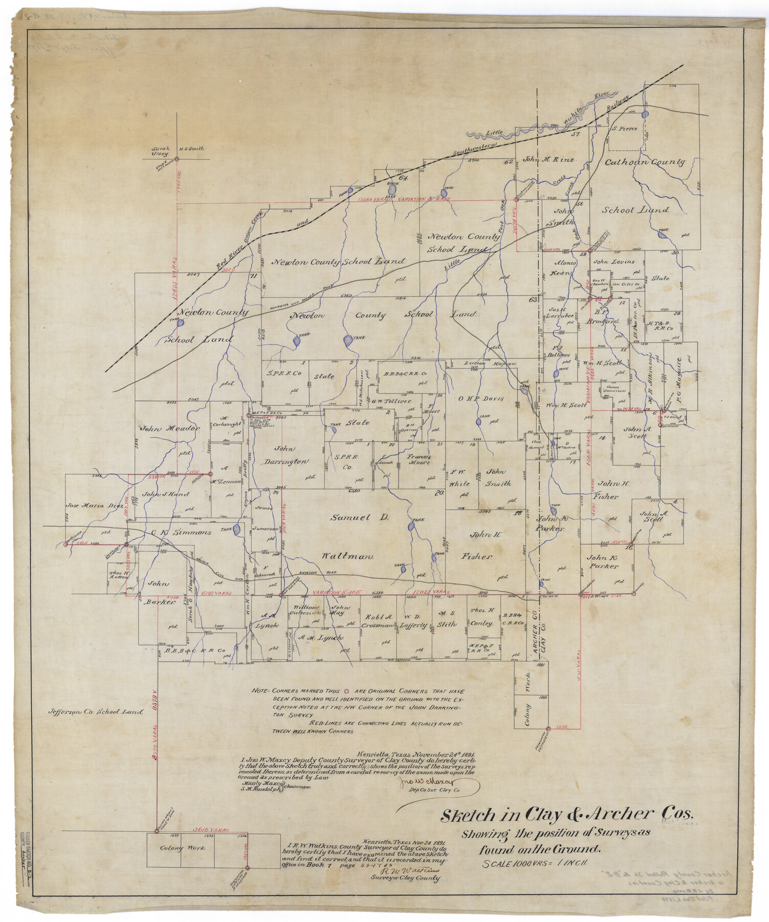
Archer County Rolled Sketch B2
Sketch in Clay & Archer Cos. [in east part of Archer County along Archer-Clay county line, south of Little Wichita River]
-
Map/Doc
5105
-
Collection
General Map Collection
-
Object Dates
1891/11/24 (Creation Date)
1892/2/8 (File Date)
-
People and Organizations
John W. Maxcy (Surveyor/Engineer)
R.W. Watkins (Surveyor/Engineer)
-
Counties
Archer Clay
-
Subjects
Surveying Rolled Sketch
-
Height x Width
36.7 x 30.7 inches
93.2 x 78.0 cm
-
Medium
linen, manuscript
-
Scale
1" = 1000 varas
Part of: General Map Collection
Randall County

Print $20.00
- Digital $50.00
Randall County
1958
Size 41.0 x 33.0 inches
Map/Doc 77402
La Salle County Sketch File 25

Print $4.00
- Digital $50.00
La Salle County Sketch File 25
Size 7.5 x 14.2 inches
Map/Doc 29549
Jeff Davis County Sketch File 32

Print $20.00
- Digital $50.00
Jeff Davis County Sketch File 32
Size 23.8 x 18.8 inches
Map/Doc 11865
Fannin County Sketch File 26

Print $4.00
- Digital $50.00
Fannin County Sketch File 26
1873
Size 8.5 x 10.3 inches
Map/Doc 22495
Jim Hogg County Sketch File 8

Print $20.00
- Digital $50.00
Jim Hogg County Sketch File 8
1941
Size 21.9 x 27.0 inches
Map/Doc 11887
Lubbock County Working Sketch 7

Print $20.00
- Digital $50.00
Lubbock County Working Sketch 7
1964
Size 21.9 x 25.3 inches
Map/Doc 70667
Calhoun County Rolled Sketch 22

Print $20.00
- Digital $50.00
Calhoun County Rolled Sketch 22
Size 35.0 x 37.0 inches
Map/Doc 8552
Morris County

Print $20.00
- Digital $50.00
Morris County
1906
Size 44.1 x 22.4 inches
Map/Doc 66944
Flight Mission No. DQO-8K, Frame 50, Galveston County

Print $20.00
- Digital $50.00
Flight Mission No. DQO-8K, Frame 50, Galveston County
1952
Size 18.7 x 22.4 inches
Map/Doc 85157
Webb County Sketch File 5a

Print $8.00
- Digital $50.00
Webb County Sketch File 5a
1877
Size 12.9 x 8.2 inches
Map/Doc 39729
Webb County Working Sketch 68

Print $40.00
- Digital $50.00
Webb County Working Sketch 68
1967
Size 31.6 x 50.7 inches
Map/Doc 72435
El Paso County Rolled Sketch 52

Print $20.00
- Digital $50.00
El Paso County Rolled Sketch 52
1929
Size 18.4 x 24.4 inches
Map/Doc 5842
You may also like
The Republic County of San Patricio. Proposed, Late Fall 1837

Print $20.00
The Republic County of San Patricio. Proposed, Late Fall 1837
2020
Size 17.8 x 21.7 inches
Map/Doc 96273
Callahan County Rolled Sketch 25

Print $20.00
- Digital $50.00
Callahan County Rolled Sketch 25
1974
Size 18.4 x 22.5 inches
Map/Doc 5383
Stephens County Working Sketch 8

Print $20.00
- Digital $50.00
Stephens County Working Sketch 8
1920
Size 21.0 x 28.7 inches
Map/Doc 63951
Kimble County Sketch File 18

Print $22.00
- Digital $50.00
Kimble County Sketch File 18
1890
Size 8.8 x 14.2 inches
Map/Doc 28953
Nueces County Sketch File 23

Print $36.00
- Digital $50.00
Nueces County Sketch File 23
1886
Size 11.2 x 8.6 inches
Map/Doc 32563
Wichita County Boundary File 2a

Print $28.00
- Digital $50.00
Wichita County Boundary File 2a
Size 14.0 x 8.9 inches
Map/Doc 59906
Survey and Location of the Corpus Christi & Rio Grande Railway Under Charter of May 24th 1873

Print $40.00
- Digital $50.00
Survey and Location of the Corpus Christi & Rio Grande Railway Under Charter of May 24th 1873
1874
Size 12.5 x 58.7 inches
Map/Doc 64092
Flight Mission No. CRC-2R, Frame 185, Chambers County

Print $20.00
- Digital $50.00
Flight Mission No. CRC-2R, Frame 185, Chambers County
1956
Size 18.8 x 22.4 inches
Map/Doc 84763
Chart of soundings through the different channels in Aransas and Matagorda Bays as taken in 1855 by Capt. R. B. Marey, U. S. A. [Inset: Harbour of Lamar and Live-Oak Pt.]
![72978, Chart of soundings through the different channels in Aransas and Matagorda Bays as taken in 1855 by Capt. R. B. Marey, U. S. A. [Inset: Harbour of Lamar and Live-Oak Pt.], General Map Collection](https://historictexasmaps.com/wmedia_w700/maps/72978.tif.jpg)
Print $20.00
- Digital $50.00
Chart of soundings through the different channels in Aransas and Matagorda Bays as taken in 1855 by Capt. R. B. Marey, U. S. A. [Inset: Harbour of Lamar and Live-Oak Pt.]
Size 28.4 x 18.3 inches
Map/Doc 72978
Stephens County Working Sketch 28

Print $20.00
- Digital $50.00
Stephens County Working Sketch 28
1976
Size 38.4 x 31.8 inches
Map/Doc 63971
[Right of Way & Track Map, The Texas & Pacific Ry. Co. Main Line]
![64673, [Right of Way & Track Map, The Texas & Pacific Ry. Co. Main Line], General Map Collection](https://historictexasmaps.com/wmedia_w700/maps/64673.tif.jpg)
Print $20.00
- Digital $50.00
[Right of Way & Track Map, The Texas & Pacific Ry. Co. Main Line]
Size 11.2 x 18.6 inches
Map/Doc 64673
La Salle County Working Sketch 47

Print $20.00
- Digital $50.00
La Salle County Working Sketch 47
1982
Size 20.3 x 20.5 inches
Map/Doc 70348