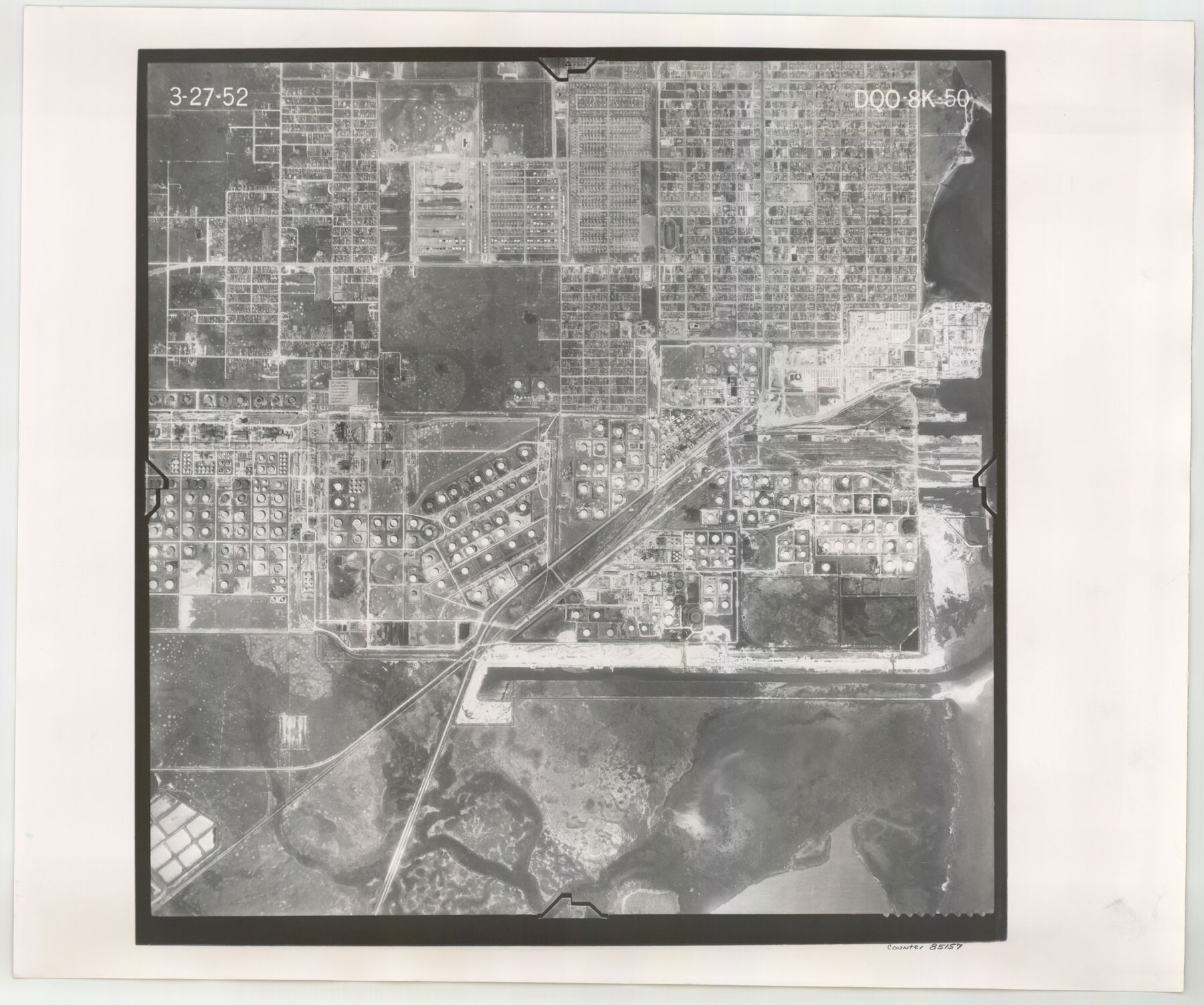
Flight Mission No. DQO-8K, Frame 50, Galveston County
DQO-8K-50
-
Map/Doc
85157
-
Collection
General Map Collection
-
Object Dates
1952/3/27 (Creation Date)
-
People and Organizations
U. S. Department of Agriculture (Publisher)
-
Counties
Galveston
-
Subjects
Aerial Photograph
-
Height x Width
18.7 x 22.4 inches
47.5 x 56.9 cm
-
Comments
Flown by Aero Exploration Company of Tulsa, Oklahoma.
Part of: General Map Collection
Texas Intracoastal Waterway - Laguna Madre - Dagger Hill to Potrero Grande

Print $20.00
- Digital $50.00
Texas Intracoastal Waterway - Laguna Madre - Dagger Hill to Potrero Grande
Size 39.0 x 27.3 inches
Map/Doc 73508
Flight Mission No. CRC-2R, Frame 194, Chambers County

Print $20.00
- Digital $50.00
Flight Mission No. CRC-2R, Frame 194, Chambers County
1956
Size 18.8 x 22.6 inches
Map/Doc 84772
Val Verde County Rolled Sketch 76

Print $20.00
- Digital $50.00
Val Verde County Rolled Sketch 76
1976
Size 38.6 x 26.6 inches
Map/Doc 8139
Map of Jack County

Print $20.00
- Digital $50.00
Map of Jack County
Size 18.7 x 15.9 inches
Map/Doc 3703
Galveston Co., 1891

Print $40.00
- Digital $50.00
Galveston Co., 1891
1891
Size 37.9 x 54.1 inches
Map/Doc 7822
Hardin County Sketch File 32a

Print $11.00
- Digital $50.00
Hardin County Sketch File 32a
Size 8.4 x 9.8 inches
Map/Doc 25167
Andrews County Rolled Sketch 10

Print $40.00
- Digital $50.00
Andrews County Rolled Sketch 10
1931
Size 27.2 x 56.1 inches
Map/Doc 8389
Flight Mission No. BRA-16M, Frame 68, Jefferson County

Print $20.00
- Digital $50.00
Flight Mission No. BRA-16M, Frame 68, Jefferson County
1953
Size 18.7 x 22.4 inches
Map/Doc 85685
Borden County Sketch File 10a

Print $40.00
- Digital $50.00
Borden County Sketch File 10a
Size 21.0 x 37.5 inches
Map/Doc 10935
Fort Bend County Sketch File 18 1/2

Print $20.00
- Digital $50.00
Fort Bend County Sketch File 18 1/2
1896
Size 18.3 x 15.3 inches
Map/Doc 11508
Donley County Working Sketch 6

Print $20.00
- Digital $50.00
Donley County Working Sketch 6
1965
Size 34.3 x 42.2 inches
Map/Doc 68739
Map of Comal County

Print $20.00
- Digital $50.00
Map of Comal County
1897
Size 40.0 x 45.8 inches
Map/Doc 66780
You may also like
Live Oak County Sketch File 26

Print $6.00
- Digital $50.00
Live Oak County Sketch File 26
1922
Size 7.1 x 8.6 inches
Map/Doc 30309
Webb County Sketch File 73

Print $20.00
- Digital $50.00
Webb County Sketch File 73
2020
Size 11.0 x 8.5 inches
Map/Doc 95917

[Sketch in Crosby County]
![89759, [Sketch in Crosby County], Twichell Survey Records](https://historictexasmaps.com/wmedia_w700/maps/89759-1.tif.jpg)
Print $40.00
- Digital $50.00
[Sketch in Crosby County]
Size 54.6 x 46.5 inches
Map/Doc 89759
[Capitol League Sketch E, Hockley County]
![1765, [Capitol League Sketch E, Hockley County], General Map Collection](https://historictexasmaps.com/wmedia_w700/maps/1765.tif.jpg)
Print $20.00
- Digital $50.00
[Capitol League Sketch E, Hockley County]
1910
Size 15.8 x 19.9 inches
Map/Doc 1765
Blanco County Working Sketch 27

Print $20.00
- Digital $50.00
Blanco County Working Sketch 27
1969
Size 31.9 x 31.8 inches
Map/Doc 67387
Bailey County Rolled Sketch 6

Print $20.00
- Digital $50.00
Bailey County Rolled Sketch 6
Size 17.4 x 12.9 inches
Map/Doc 5111
United States - Gulf Coast - Galveston to Rio Grande

Print $20.00
- Digital $50.00
United States - Gulf Coast - Galveston to Rio Grande
Size 27.9 x 18.3 inches
Map/Doc 72739
Red River County Sketch File 15

Print $4.00
- Digital $50.00
Red River County Sketch File 15
1863
Size 12.1 x 7.2 inches
Map/Doc 35137
San Augustine County Sketch File 3

Print $10.00
San Augustine County Sketch File 3
1858
Size 11.8 x 8.1 inches
Map/Doc 35635

Map of Henderson County

Print $20.00
- Digital $50.00
Map of Henderson County
1877
Size 17.7 x 29.2 inches
Map/Doc 3666