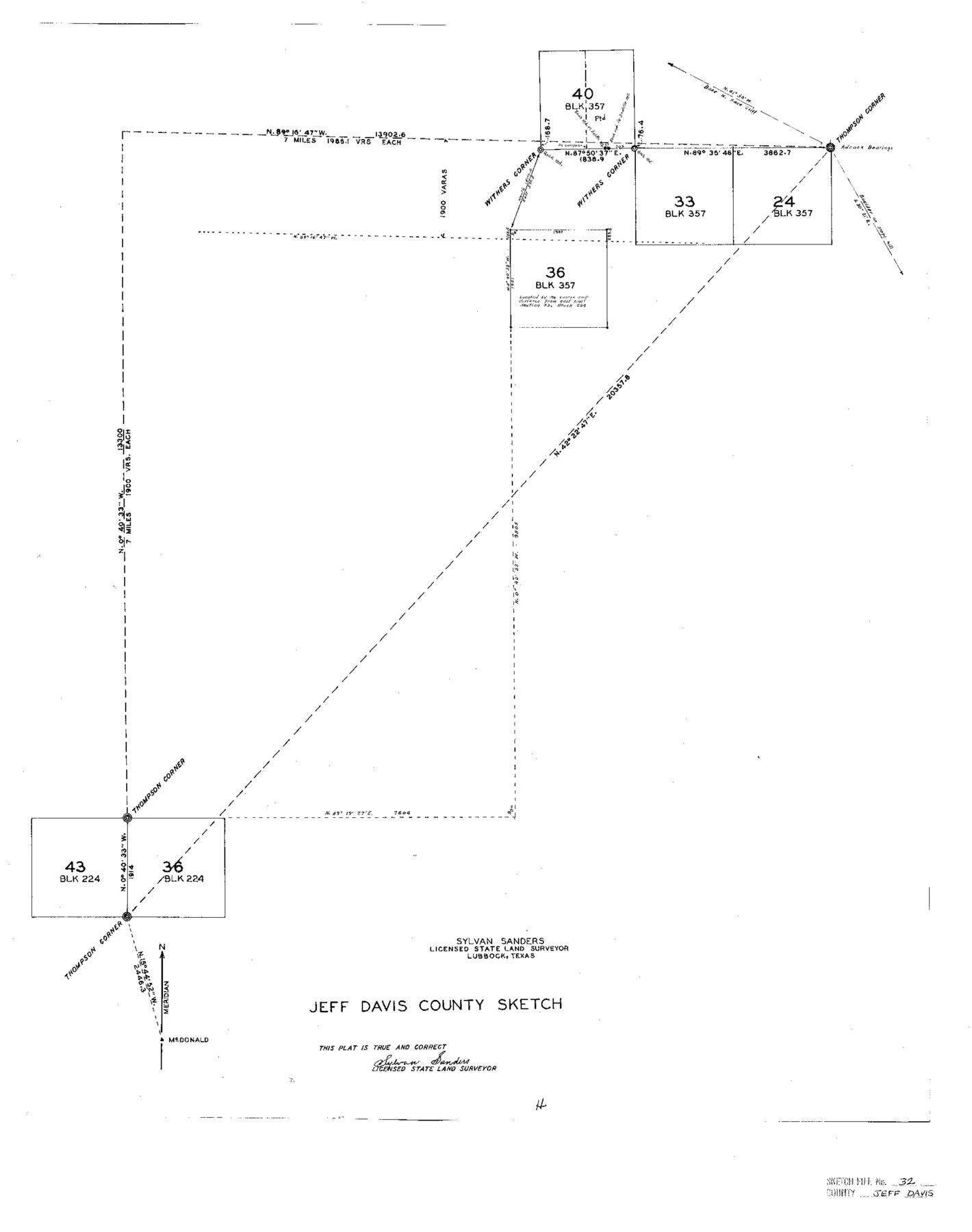
Jeff Davis County Sketch File 32
Connecting line Block 357 Block 311 and Block 224
-
Map/Doc
11865
-
Collection
General Map Collection
-
Object Dates
3/10/1944 (File Date)
-
People and Organizations
Sylvan Sanders (Surveyor/Engineer)
-
Counties
Jeff Davis
-
Subjects
Surveying Sketch File
-
Height x Width
23.8 x 18.8 inches
60.5 x 47.8 cm
-
Medium
paper, print
Part of: General Map Collection
Map of Maryland, Virginia, North Carolina and South Carolina

Print $20.00
- Digital $50.00
Map of Maryland, Virginia, North Carolina and South Carolina
1885
Size 12.2 x 9.0 inches
Map/Doc 93517
Cottle County Sketch File 6

Print $20.00
- Digital $50.00
Cottle County Sketch File 6
1883
Size 20.3 x 29.8 inches
Map/Doc 11190
McLennan County Sketch File 11

Print $8.00
- Digital $50.00
McLennan County Sketch File 11
1860
Size 9.0 x 7.7 inches
Map/Doc 31262
Zavala County Sketch File 11

Print $4.00
- Digital $50.00
Zavala County Sketch File 11
1885
Size 14.4 x 8.8 inches
Map/Doc 41270
King County Working Sketch 10

Print $20.00
- Digital $50.00
King County Working Sketch 10
1956
Size 19.1 x 13.9 inches
Map/Doc 70174
Dallas County Boundary File 4

Print $38.00
- Digital $50.00
Dallas County Boundary File 4
Size 8.9 x 3.9 inches
Map/Doc 52123
Atascosa County Rolled Sketch 25

Print $20.00
- Digital $50.00
Atascosa County Rolled Sketch 25
Size 25.2 x 20.5 inches
Map/Doc 93551
Bosque County Working Sketch 27

Print $20.00
- Digital $50.00
Bosque County Working Sketch 27
2006
Size 29.8 x 38.0 inches
Map/Doc 85241
Flight Mission No. DQN-1K, Frame 120, Calhoun County

Print $20.00
- Digital $50.00
Flight Mission No. DQN-1K, Frame 120, Calhoun County
1953
Size 18.5 x 22.2 inches
Map/Doc 84186
Brazoria County Aerial Photograph Index Sheet 5

Print $20.00
- Digital $50.00
Brazoria County Aerial Photograph Index Sheet 5
1953
Size 24.0 x 19.5 inches
Map/Doc 83667
San Augustine County Working Sketch 17

Print $20.00
- Digital $50.00
San Augustine County Working Sketch 17
1963
Size 20.3 x 21.5 inches
Map/Doc 63705
Brewster County Rolled Sketch 138

Print $20.00
- Digital $50.00
Brewster County Rolled Sketch 138
1982
Size 24.5 x 38.0 inches
Map/Doc 5306
You may also like
Kimble County

Print $40.00
- Digital $50.00
Kimble County
1890
Size 39.2 x 57.5 inches
Map/Doc 78435
Flight Mission No. CRC-4R, Frame 96, Chambers County

Print $20.00
- Digital $50.00
Flight Mission No. CRC-4R, Frame 96, Chambers County
1956
Size 18.4 x 22.2 inches
Map/Doc 84893
Lake Austin, Travis County, Texas

Print $20.00
- Digital $50.00
Lake Austin, Travis County, Texas
1937
Size 24.8 x 16.4 inches
Map/Doc 2056
Montague County Working Sketch 14

Print $20.00
- Digital $50.00
Montague County Working Sketch 14
1940
Size 28.4 x 17.9 inches
Map/Doc 71080
Proceedings of The International (Water) Boundary Commission United States and Mexico Treaties of 1884 and 1889, Volume 1

Proceedings of The International (Water) Boundary Commission United States and Mexico Treaties of 1884 and 1889, Volume 1
Map/Doc 83144
Hemphill County Rolled Sketch 6

Print $20.00
- Digital $50.00
Hemphill County Rolled Sketch 6
Size 22.2 x 24.7 inches
Map/Doc 6188
Edwards County Working Sketch 139

Print $20.00
- Digital $50.00
Edwards County Working Sketch 139
Size 20.9 x 21.4 inches
Map/Doc 62184
Township 9 North Range 14 West, North Western District, Louisiana

Print $20.00
- Digital $50.00
Township 9 North Range 14 West, North Western District, Louisiana
1854
Size 19.5 x 24.6 inches
Map/Doc 65873
[John H. Stephens Blk. S-2, Capitol Lgs. to North and County School to the South]
![90241, [John H. Stephens Blk. S-2, Capitol Lgs. to North and County School to the South], Twichell Survey Records](https://historictexasmaps.com/wmedia_w700/maps/90241-1.tif.jpg)
Print $20.00
- Digital $50.00
[John H. Stephens Blk. S-2, Capitol Lgs. to North and County School to the South]
1903
Size 20.7 x 18.3 inches
Map/Doc 90241
Atascosa County Working Sketch 23

Print $40.00
- Digital $50.00
Atascosa County Working Sketch 23
1958
Size 38.8 x 57.1 inches
Map/Doc 68434
Duval County Sketch File 62

Print $40.00
- Digital $50.00
Duval County Sketch File 62
1941
Size 14.0 x 12.5 inches
Map/Doc 21434
Jasper County Rolled Sketch 5

Print $20.00
- Digital $50.00
Jasper County Rolled Sketch 5
1948
Size 29.0 x 24.4 inches
Map/Doc 6352