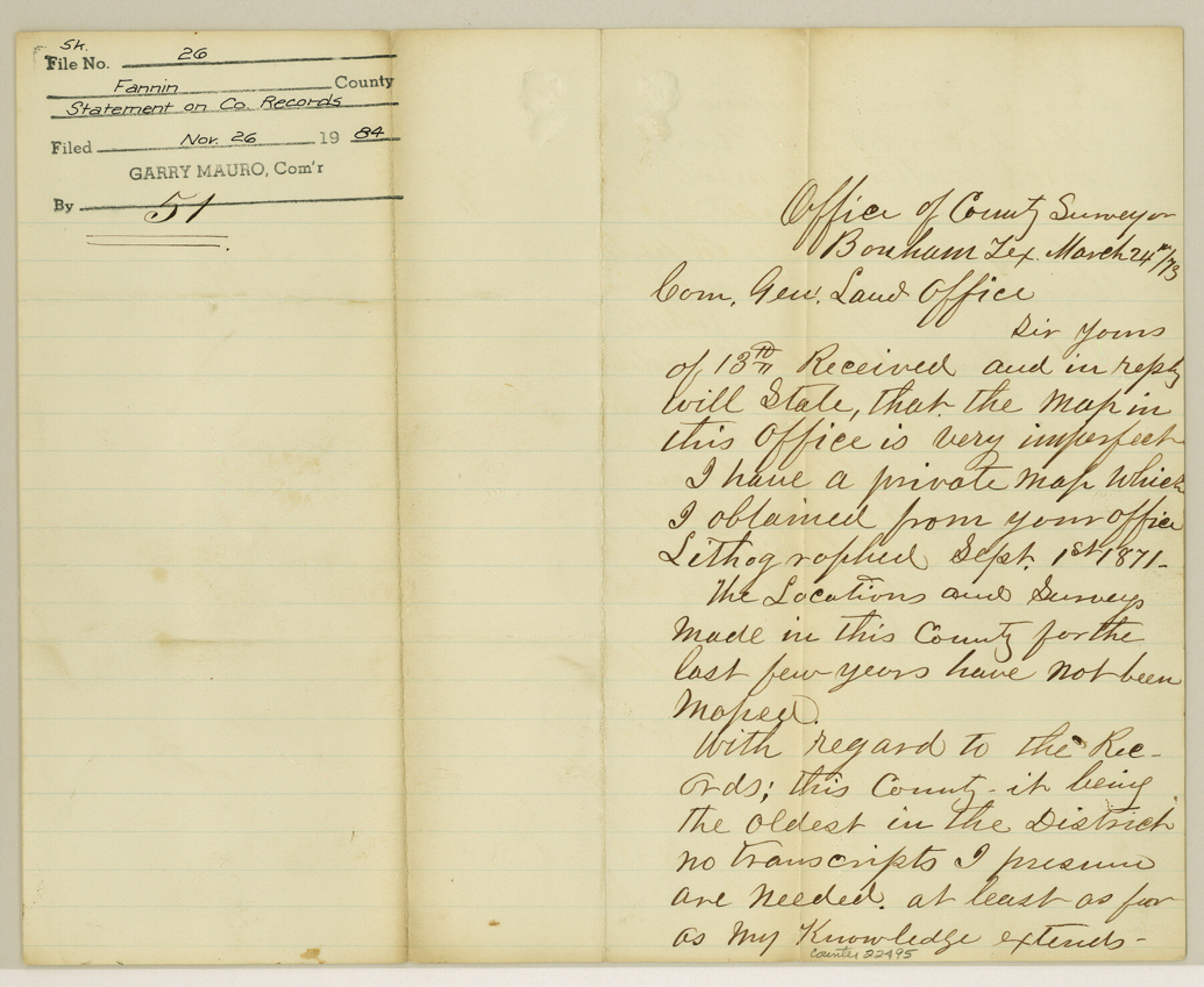
Fannin County Sketch File 26
[Surveyor's statement on county records]
-
Map/Doc
22495
-
Collection
General Map Collection
-
Object Dates
1873/3/24 (Creation Date)
1984/11/26 (File Date)
-
Counties
Fannin
-
Subjects
Surveying Sketch File
-
Height x Width
8.5 x 10.3 inches
21.6 x 26.2 cm
-
Medium
paper, manuscript
Part of: General Map Collection
Flight Mission No. DQN-2K, Frame 123, Calhoun County

Print $20.00
- Digital $50.00
Flight Mission No. DQN-2K, Frame 123, Calhoun County
1953
Size 16.6 x 16.5 inches
Map/Doc 84299
Val Verde County Working Sketch 26

Print $20.00
- Digital $50.00
Val Verde County Working Sketch 26
1936
Size 22.9 x 31.5 inches
Map/Doc 72161
Val Verde County Rolled Sketch 58

Print $20.00
- Digital $50.00
Val Verde County Rolled Sketch 58
1938
Size 17.9 x 22.4 inches
Map/Doc 8126
Flight Mission No. CRE-2R, Frame 88, Jackson County

Print $20.00
- Digital $50.00
Flight Mission No. CRE-2R, Frame 88, Jackson County
1956
Size 15.9 x 15.9 inches
Map/Doc 85360
Map showing resurvey of Capitol Leagues, Oldham Co., Texas

Print $40.00
- Digital $50.00
Map showing resurvey of Capitol Leagues, Oldham Co., Texas
1918
Size 38.6 x 51.0 inches
Map/Doc 1755
Houston including Bellaire, Bunker Hill, Galena Park, Hedwig, Hilshire, Hunters Creek, Jacinto City, Jersey Village, Missouri City, Pasadena, Piney Point, South Houston, Spring Valley, West University Place and adjoining communities [Verso]
![94180, Houston including Bellaire, Bunker Hill, Galena Park, Hedwig, Hilshire, Hunters Creek, Jacinto City, Jersey Village, Missouri City, Pasadena, Piney Point, South Houston, Spring Valley, West University Place and adjoining communities [Verso], General Map Collection](https://historictexasmaps.com/wmedia_w700/maps/94180.tif.jpg)
Houston including Bellaire, Bunker Hill, Galena Park, Hedwig, Hilshire, Hunters Creek, Jacinto City, Jersey Village, Missouri City, Pasadena, Piney Point, South Houston, Spring Valley, West University Place and adjoining communities [Verso]
Size 27.1 x 42.4 inches
Map/Doc 94180
Clay County Sketch File 39

Print $10.00
- Digital $50.00
Clay County Sketch File 39
1940
Size 14.3 x 8.7 inches
Map/Doc 18472
Grimes County Working Sketch Graphic Index

Print $40.00
- Digital $50.00
Grimes County Working Sketch Graphic Index
1922
Size 54.9 x 29.4 inches
Map/Doc 76560
Real County Working Sketch 10

Print $20.00
- Digital $50.00
Real County Working Sketch 10
1929
Size 23.0 x 15.4 inches
Map/Doc 71902
Bailey County Sketch File 8

Print $6.00
- Digital $50.00
Bailey County Sketch File 8
1913
Size 8.8 x 14.3 inches
Map/Doc 13962

Taylor County, Texas

Print $20.00
- Digital $50.00
Taylor County, Texas
1890
Size 28.7 x 21.6 inches
Map/Doc 574
You may also like
Montgomery County

Print $20.00
- Digital $50.00
Montgomery County
1861
Size 18.4 x 22.3 inches
Map/Doc 3890
Llano County Working Sketch 9

Print $20.00
- Digital $50.00
Llano County Working Sketch 9
1979
Size 33.4 x 24.0 inches
Map/Doc 70627
Kerr County Working Sketch 1

Print $20.00
- Digital $50.00
Kerr County Working Sketch 1
1900
Size 18.5 x 18.0 inches
Map/Doc 70032
Flight Mission No. DQN-2K, Frame 136, Calhoun County

Print $20.00
- Digital $50.00
Flight Mission No. DQN-2K, Frame 136, Calhoun County
1953
Size 18.5 x 15.8 inches
Map/Doc 84305
[Map of the Hearne and Brazos Valley Railroad from Mumford to Moseley's Ferry]
![64401, [Map of the Hearne and Brazos Valley Railroad from Mumford to Moseley's Ferry], General Map Collection](https://historictexasmaps.com/wmedia_w700/maps/64401.tif.jpg)
Print $40.00
- Digital $50.00
[Map of the Hearne and Brazos Valley Railroad from Mumford to Moseley's Ferry]
1892
Size 20.0 x 71.5 inches
Map/Doc 64401
Flight Mission No. BRA-16M, Frame 62, Jefferson County

Print $20.00
- Digital $50.00
Flight Mission No. BRA-16M, Frame 62, Jefferson County
1953
Size 18.7 x 22.4 inches
Map/Doc 85679
Kerr County Rolled Sketch 27

Print $20.00
- Digital $50.00
Kerr County Rolled Sketch 27
1983
Size 33.1 x 33.5 inches
Map/Doc 6506
Knox County Sketch File 24

Print $6.00
- Digital $50.00
Knox County Sketch File 24
1945
Size 14.2 x 9.0 inches
Map/Doc 29254
Cass County Rolled Sketch 1

Print $20.00
- Digital $50.00
Cass County Rolled Sketch 1
1945
Size 22.1 x 23.7 inches
Map/Doc 5408
Castro County Working Sketch 8
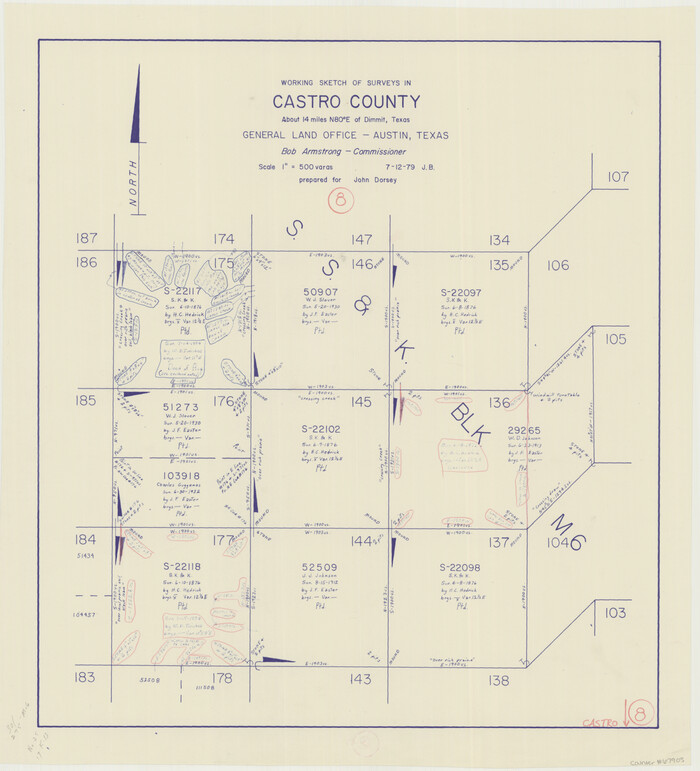
Print $20.00
- Digital $50.00
Castro County Working Sketch 8
1979
Size 21.2 x 19.3 inches
Map/Doc 67903
Navarro County Rolled Sketch 7

Print $20.00
- Digital $50.00
Navarro County Rolled Sketch 7
Size 45.0 x 34.6 inches
Map/Doc 10308
Val Verde County Sketch File 14

Print $20.00
- Digital $50.00
Val Verde County Sketch File 14
1879
Size 19.8 x 14.7 inches
Map/Doc 12565