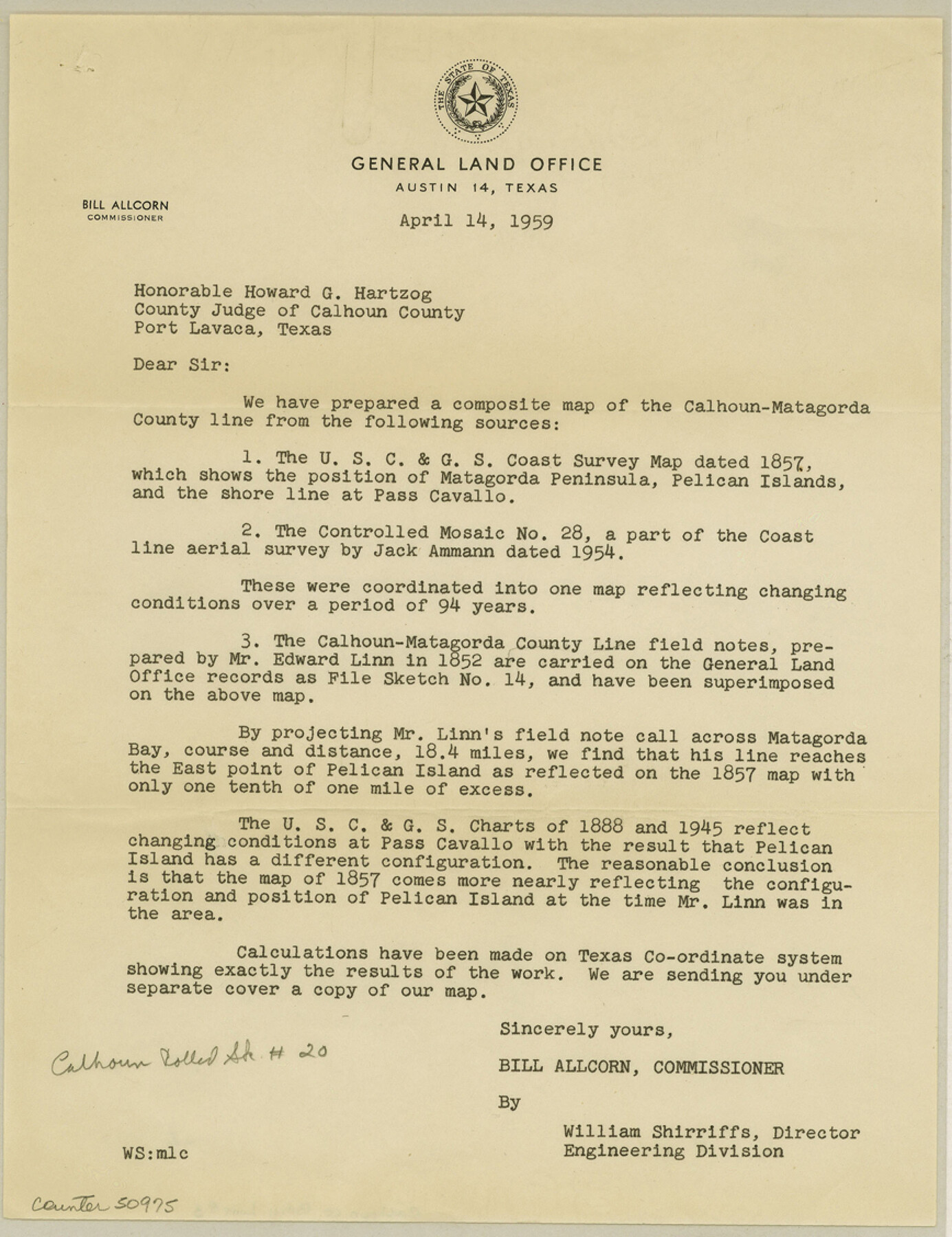
Calhoun County Boundary File 3
[Letter to County Judge (Calhoun) regarding Calhoun-Matagorda County Line]
-
Map/Doc
50975
-
Collection
General Map Collection
-
Counties
Calhoun
-
Subjects
County Boundaries
-
Height x Width
11.3 x 8.7 inches
28.7 x 22.1 cm
Part of: General Map Collection
Hardeman County Rolled Sketch 23

Print $20.00
- Digital $50.00
Hardeman County Rolled Sketch 23
1952
Size 34.6 x 30.8 inches
Map/Doc 10671
Jones County Sketch File 10

Print $20.00
- Digital $50.00
Jones County Sketch File 10
1875
Size 14.3 x 22.2 inches
Map/Doc 11900
Map of Jefferson County Texas

Print $20.00
- Digital $50.00
Map of Jefferson County Texas
1879
Size 23.3 x 20.6 inches
Map/Doc 3729
Flight Mission No. DQO-7K, Frame 102, Galveston County

Print $20.00
- Digital $50.00
Flight Mission No. DQO-7K, Frame 102, Galveston County
1952
Size 18.6 x 22.5 inches
Map/Doc 85117
Flight Mission No. CUG-3P, Frame 89, Kleberg County

Print $20.00
- Digital $50.00
Flight Mission No. CUG-3P, Frame 89, Kleberg County
1956
Size 18.4 x 22.1 inches
Map/Doc 86259
Houston County Working Sketch 5

Print $20.00
- Digital $50.00
Houston County Working Sketch 5
Size 24.9 x 28.1 inches
Map/Doc 66235
Hall County Rolled Sketch 9

Print $20.00
- Digital $50.00
Hall County Rolled Sketch 9
1946
Size 22.0 x 40.4 inches
Map/Doc 6053
Ferguson State Farm

Print $20.00
- Digital $50.00
Ferguson State Farm
Size 19.2 x 20.4 inches
Map/Doc 62990
Duval County Rolled Sketch Pressly No. 2

Print $20.00
- Digital $50.00
Duval County Rolled Sketch Pressly No. 2
1935
Size 22.6 x 33.7 inches
Map/Doc 5770
Llano County Boundary File 2

Print $30.00
- Digital $50.00
Llano County Boundary File 2
Size 14.3 x 8.8 inches
Map/Doc 56443
Kerr County Rolled Sketch 21

Print $20.00
- Digital $50.00
Kerr County Rolled Sketch 21
1959
Size 44.5 x 30.5 inches
Map/Doc 9348
Aransas County NRC Article 33.136 Sketch 22

Print $24.00
Aransas County NRC Article 33.136 Sketch 22
2023
Map/Doc 97270
You may also like
Fisher County Sketch File 23

Print $12.00
- Digital $50.00
Fisher County Sketch File 23
1875
Size 10.8 x 8.2 inches
Map/Doc 22660

Record of Spanish Titles, Vol. III

Record of Spanish Titles, Vol. III
1845
Size 18.2 x 11.9 inches
Map/Doc 94528
San Augustine County Working Sketch 28

Print $20.00
- Digital $50.00
San Augustine County Working Sketch 28
2011
Size 23.4 x 36.7 inches
Map/Doc 90091
Hardeman County Rolled Sketch 17

Print $40.00
- Digital $50.00
Hardeman County Rolled Sketch 17
1888
Size 57.9 x 31.1 inches
Map/Doc 9100
Upton County Rolled Sketch 59A

Print $20.00
- Digital $50.00
Upton County Rolled Sketch 59A
Size 35.5 x 46.3 inches
Map/Doc 76424
Flight Mission No. BRA-7M, Frame 125, Jefferson County

Print $20.00
- Digital $50.00
Flight Mission No. BRA-7M, Frame 125, Jefferson County
1953
Size 16.3 x 16.1 inches
Map/Doc 85519
[T. & N. O. Railroad Company, Block 2T]
![91516, [T. & N. O. Railroad Company, Block 2T], Twichell Survey Records](https://historictexasmaps.com/wmedia_w700/maps/91516-1.tif.jpg)
Print $20.00
- Digital $50.00
[T. & N. O. Railroad Company, Block 2T]
Size 30.6 x 9.5 inches
Map/Doc 91516
Houston County

Print $20.00
- Digital $50.00
Houston County
1868
Size 25.5 x 26.1 inches
Map/Doc 3685
Dimmit County Working Sketch 11

Print $20.00
- Digital $50.00
Dimmit County Working Sketch 11
1935
Size 28.7 x 31.7 inches
Map/Doc 68672
Flight Mission No. DCL-4C, Frame 145, Kenedy County

Print $20.00
- Digital $50.00
Flight Mission No. DCL-4C, Frame 145, Kenedy County
1943
Size 18.6 x 22.4 inches
Map/Doc 85823
Glasscock County Sketch File 15

Print $8.00
- Digital $50.00
Glasscock County Sketch File 15
1935
Size 11.3 x 8.8 inches
Map/Doc 24182