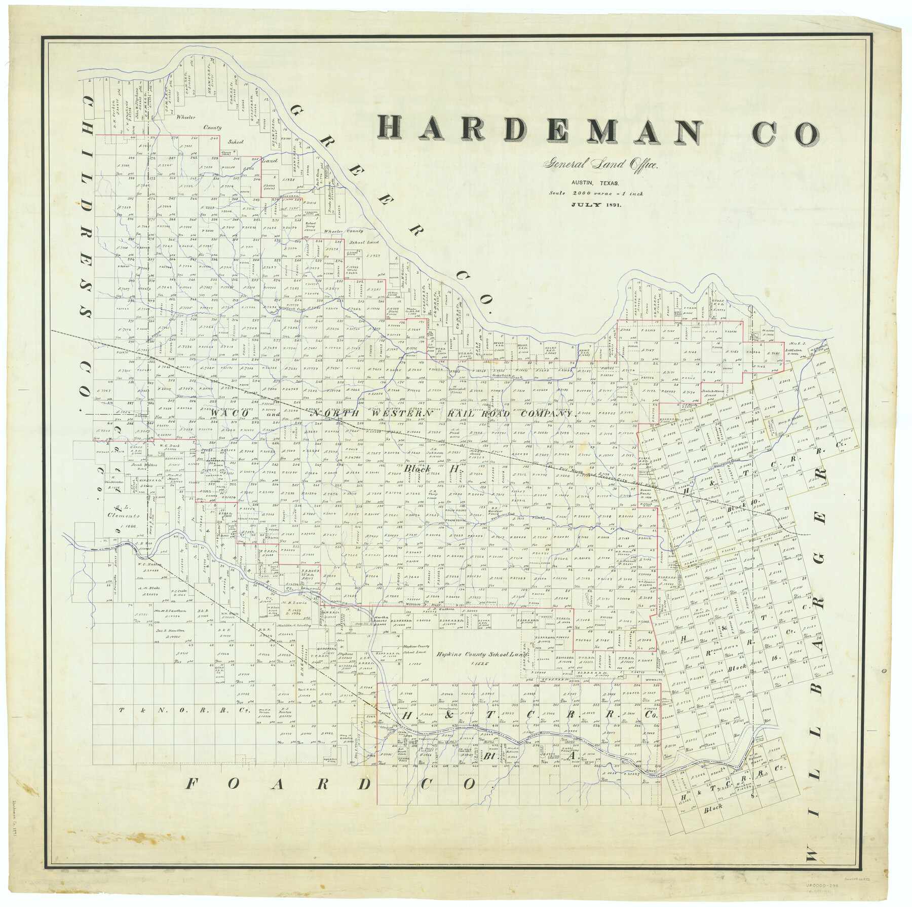
Hardeman Co.
-
Map/Doc
66852
-
Collection
General Map Collection
-
Object Dates
1891 (Creation Date)
-
People and Organizations
Texas General Land Office (Publisher)
-
Counties
Hardeman
-
Subjects
County
-
Height x Width
42.5 x 42.7 inches
108.0 x 108.5 cm
Part of: General Map Collection
Foard County Rolled Sketch 13

Print $20.00
- Digital $50.00
Foard County Rolled Sketch 13
1958
Size 25.2 x 31.4 inches
Map/Doc 5887
Colorado River, Bonus Sheet

Print $6.00
- Digital $50.00
Colorado River, Bonus Sheet
1941
Size 24.2 x 30.4 inches
Map/Doc 65307
Bandera County Working Sketch 57

Print $20.00
- Digital $50.00
Bandera County Working Sketch 57
1991
Size 38.5 x 46.8 inches
Map/Doc 67653
Engineer's Office, Department of the Gulf Map No. 59, Texas prepared by order of Maj. Gen. N. P. Banks under direction of Capt. P. C. Hains, U. S. Engr. & Chief Engr., Dept. of the Gulf

Print $20.00
- Digital $50.00
Engineer's Office, Department of the Gulf Map No. 59, Texas prepared by order of Maj. Gen. N. P. Banks under direction of Capt. P. C. Hains, U. S. Engr. & Chief Engr., Dept. of the Gulf
1865
Size 18.2 x 27.5 inches
Map/Doc 72718
Robertson County Working Sketch 20

Print $40.00
- Digital $50.00
Robertson County Working Sketch 20
2005
Size 27.5 x 50.0 inches
Map/Doc 83583
Liberty County Sketch File 32

Print $8.00
- Digital $50.00
Liberty County Sketch File 32
1872
Size 10.3 x 8.2 inches
Map/Doc 29961
Webb County Working Sketch 79

Print $20.00
- Digital $50.00
Webb County Working Sketch 79
1977
Size 31.0 x 28.3 inches
Map/Doc 72446
Trinity County Sketch File 29

Print $20.00
- Digital $50.00
Trinity County Sketch File 29
1859
Size 18.1 x 37.1 inches
Map/Doc 12488
Medina County Rolled Sketch 19

Print $40.00
- Digital $50.00
Medina County Rolled Sketch 19
1987
Size 45.1 x 57.8 inches
Map/Doc 9508
Young County Sketch File 14

Print $20.00
- Digital $50.00
Young County Sketch File 14
1895
Size 10.9 x 27.3 inches
Map/Doc 12712

Jones County Sketch File 16

Print $20.00
- Digital $50.00
Jones County Sketch File 16
1945
Size 23.7 x 19.0 inches
Map/Doc 11901
You may also like
Kimble County Working Sketch 38

Print $20.00
- Digital $50.00
Kimble County Working Sketch 38
1946
Size 37.4 x 26.2 inches
Map/Doc 70106

Tom Green County Sketch File 30

Print $12.00
Tom Green County Sketch File 30
1880
Size 11.0 x 8.2 inches
Map/Doc 38182
Anderson County Sketch File 27

Print $40.00
- Digital $50.00
Anderson County Sketch File 27
1970
Size 19.5 x 23.7 inches
Map/Doc 10806

Bee County, Texas

Print $20.00
- Digital $50.00
Bee County, Texas
1879
Size 25.5 x 21.7 inches
Map/Doc 510
El Paso County Rolled Sketch 58

Print $20.00
- Digital $50.00
El Paso County Rolled Sketch 58
1987
Size 18.6 x 24.6 inches
Map/Doc 5851
Kendall County Rolled Sketch 6

Print $20.00
- Digital $50.00
Kendall County Rolled Sketch 6
Size 29.6 x 39.4 inches
Map/Doc 6459
General Highway Map, Kent County, Texas

Print $20.00
General Highway Map, Kent County, Texas
1940
Size 18.4 x 24.9 inches
Map/Doc 79156
Subdivision of Tract 2, Soash-White Industrial Addition, Part of Southeast Quarter, Section 2, Block E (Geo. W. Soash - J. B. White, Owners)

Print $20.00
- Digital $50.00
Subdivision of Tract 2, Soash-White Industrial Addition, Part of Southeast Quarter, Section 2, Block E (Geo. W. Soash - J. B. White, Owners)
1956
Size 22.8 x 17.6 inches
Map/Doc 92775
Shelby County Sketch File 8

Print $4.00
- Digital $50.00
Shelby County Sketch File 8
Size 10.1 x 7.9 inches
Map/Doc 36607
Ward County Boundary File 3a

Print $22.00
- Digital $50.00
Ward County Boundary File 3a
Size 13.1 x 8.6 inches
Map/Doc 59684