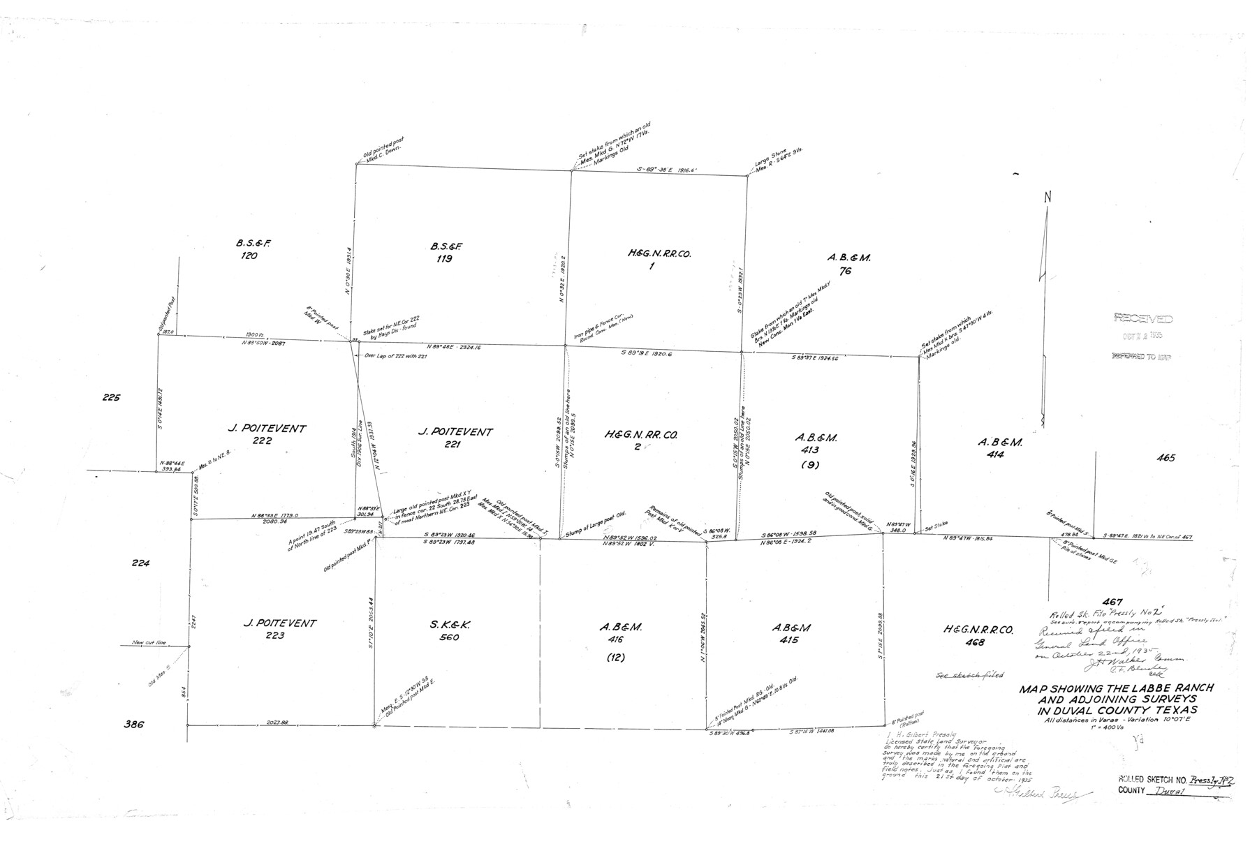
Duval County Rolled Sketch Pressly No. 2
Map showing the Labbe Ranch and adjoining surveys in Duval County, Texas
-
Map/Doc
5770
-
Collection
General Map Collection
-
Object Dates
1935/10/21 (Creation Date)
1935/10/22 (File Date)
-
People and Organizations
H. Gilbert Pressly (Surveyor/Engineer)
-
Counties
Duval
-
Subjects
Surveying Rolled Sketch
-
Height x Width
22.6 x 33.7 inches
57.4 x 85.6 cm
-
Scale
1" = 400 varas
Part of: General Map Collection
Navarro County Sketch File 2

Print $4.00
- Digital $50.00
Navarro County Sketch File 2
1857
Size 9.4 x 8.2 inches
Map/Doc 32298
Flight Mission No. DAG-23K, Frame 166, Matagorda County

Print $20.00
- Digital $50.00
Flight Mission No. DAG-23K, Frame 166, Matagorda County
1953
Size 15.9 x 19.1 inches
Map/Doc 86504
Hemphill County Working Sketch 12

Print $20.00
- Digital $50.00
Hemphill County Working Sketch 12
1967
Size 23.3 x 34.9 inches
Map/Doc 66107
Bell County Working Sketch 6

Print $20.00
- Digital $50.00
Bell County Working Sketch 6
1946
Size 24.9 x 33.6 inches
Map/Doc 67346
Blanco County Working Sketch 43

Print $20.00
- Digital $50.00
Blanco County Working Sketch 43
1993
Size 42.7 x 26.5 inches
Map/Doc 67403
Sutton County Rolled Sketch 64

Print $20.00
- Digital $50.00
Sutton County Rolled Sketch 64
1975
Size 17.9 x 19.6 inches
Map/Doc 7899
Montague County Working Sketch 29

Print $20.00
- Digital $50.00
Montague County Working Sketch 29
1972
Size 27.8 x 22.1 inches
Map/Doc 71095
McLennan County Working Sketch 5

Print $20.00
- Digital $50.00
McLennan County Working Sketch 5
1943
Size 14.6 x 12.8 inches
Map/Doc 70698
Ward County Working Sketch Graphic Index - sheet A

Print $40.00
- Digital $50.00
Ward County Working Sketch Graphic Index - sheet A
1932
Size 30.8 x 52.8 inches
Map/Doc 76731
Upton County Working Sketch 60

Print $20.00
- Digital $50.00
Upton County Working Sketch 60
2012
Size 34.2 x 32.1 inches
Map/Doc 93387
Harris County Working Sketch 63

Print $20.00
- Digital $50.00
Harris County Working Sketch 63
1954
Size 34.0 x 36.8 inches
Map/Doc 65955
Jasper County Working Sketch 28

Print $20.00
- Digital $50.00
Jasper County Working Sketch 28
1955
Size 22.6 x 15.6 inches
Map/Doc 66490
You may also like
Midland County Rolled Sketch 2

Print $20.00
- Digital $50.00
Midland County Rolled Sketch 2
1949
Size 39.3 x 36.5 inches
Map/Doc 9513
Flight Mission No. DCL-4C, Frame 65, Kenedy County

Print $20.00
- Digital $50.00
Flight Mission No. DCL-4C, Frame 65, Kenedy County
1943
Size 18.5 x 22.3 inches
Map/Doc 85810
Hidalgo County Working Sketch 4

Print $20.00
- Digital $50.00
Hidalgo County Working Sketch 4
1938
Size 43.1 x 39.6 inches
Map/Doc 66181
Galveston County Rolled Sketch 26

Print $950.00
- Digital $50.00
Galveston County Rolled Sketch 26
Size 10.6 x 16.1 inches
Map/Doc 44849
Topographical Map of the Rio Grande, Sheet No. 30

Print $20.00
- Digital $50.00
Topographical Map of the Rio Grande, Sheet No. 30
1912
Map/Doc 89554
North Half - Brown County, Texas

Print $40.00
- Digital $50.00
North Half - Brown County, Texas
1919
Size 42.2 x 64.8 inches
Map/Doc 97382
[Block 47, Sections 17- 29]
![91176, [Block 47, Sections 17- 29], Twichell Survey Records](https://historictexasmaps.com/wmedia_w700/maps/91176-1.tif.jpg)
Print $20.00
- Digital $50.00
[Block 47, Sections 17- 29]
Size 25.2 x 18.4 inches
Map/Doc 91176
[Sketch of 'San Salvador del Tule', Juan Jose Balli Grant, Hidalgo County, Texas]
![10756, [Sketch of 'San Salvador del Tule', Juan Jose Balli Grant, Hidalgo County, Texas], Maddox Collection](https://historictexasmaps.com/wmedia_w700/maps/10756.tif.jpg)
Print $20.00
- Digital $50.00
[Sketch of 'San Salvador del Tule', Juan Jose Balli Grant, Hidalgo County, Texas]
Size 22.0 x 17.5 inches
Map/Doc 10756
Fort Bend County Working Sketch 20

Print $20.00
- Digital $50.00
Fort Bend County Working Sketch 20
1967
Size 22.4 x 33.4 inches
Map/Doc 69226
Howard County Sketch File 11

Print $40.00
- Digital $50.00
Howard County Sketch File 11
1937
Size 17.6 x 10.2 inches
Map/Doc 26865
Stonewall County Sketch File 19

Print $20.00
- Digital $50.00
Stonewall County Sketch File 19
Size 33.2 x 33.6 inches
Map/Doc 10392
Duval County Sketch File 51

Print $20.00
- Digital $50.00
Duval County Sketch File 51
Size 19.1 x 33.8 inches
Map/Doc 11401