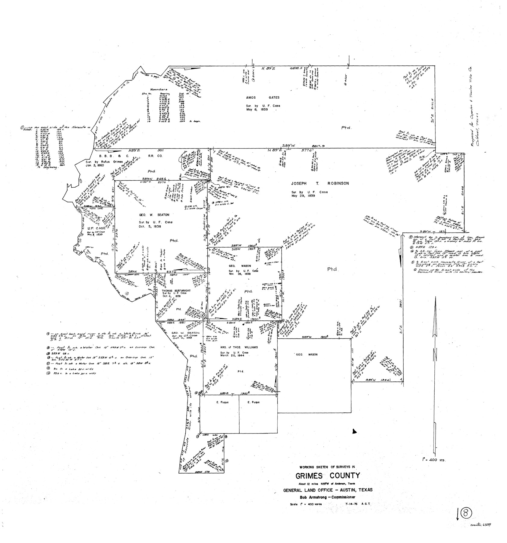
Grimes County Working Sketch 8
-
Map/Doc
63299
-
Collection
General Map Collection
-
Object Dates
7/14/1976 (Creation Date)
-
People and Organizations
Abner G. Trigg (Draftsman)
-
Counties
Grimes
-
Subjects
Surveying Working Sketch
-
Height x Width
35.0 x 32.7 inches
88.9 x 83.1 cm
-
Scale
1" = 400 varas
Part of: General Map Collection
Pecos County Working Sketch 138

Print $20.00
- Digital $50.00
Pecos County Working Sketch 138
1981
Size 23.2 x 26.3 inches
Map/Doc 71612
Flight Mission No. DQN-2K, Frame 75, Calhoun County

Print $20.00
- Digital $50.00
Flight Mission No. DQN-2K, Frame 75, Calhoun County
1953
Size 18.7 x 22.3 inches
Map/Doc 84267
Bailey County Sketch File 5

Print $40.00
- Digital $50.00
Bailey County Sketch File 5
1907
Size 31.9 x 22.8 inches
Map/Doc 10883
Roberts County Rolled Sketch 3

Print $40.00
- Digital $50.00
Roberts County Rolled Sketch 3
Size 38.0 x 49.7 inches
Map/Doc 8354
Concho County Rolled Sketch 5

Print $20.00
- Digital $50.00
Concho County Rolled Sketch 5
1950
Size 41.9 x 27.6 inches
Map/Doc 5545
Goliad County Working Sketch 25

Print $20.00
- Digital $50.00
Goliad County Working Sketch 25
1994
Size 19.6 x 21.9 inches
Map/Doc 63215
Stonewall County Rolled Sketch 29

Print $20.00
- Digital $50.00
Stonewall County Rolled Sketch 29
Size 39.8 x 40.0 inches
Map/Doc 9968
Crane County Sketch File 23a

Print $6.00
- Digital $50.00
Crane County Sketch File 23a
1931
Size 14.4 x 8.9 inches
Map/Doc 19593
Cottle County Sketch File 1

Print $20.00
- Digital $50.00
Cottle County Sketch File 1
1882
Size 20.7 x 18.9 inches
Map/Doc 11189
Hutchinson County Working Sketch 18

Print $20.00
- Digital $50.00
Hutchinson County Working Sketch 18
1956
Size 31.4 x 18.3 inches
Map/Doc 66378
Real County Working Sketch 81

Print $20.00
- Digital $50.00
Real County Working Sketch 81
1984
Size 19.9 x 17.1 inches
Map/Doc 71973
Sherman County Sketch File 2

Print $20.00
- Digital $50.00
Sherman County Sketch File 2
Size 19.5 x 36.3 inches
Map/Doc 12323
You may also like

Map of Menard County

Print $20.00
- Digital $50.00
Map of Menard County
1898
Size 19.9 x 43.1 inches
Map/Doc 5042
Current Miscellaneous File 97

Print $16.00
- Digital $50.00
Current Miscellaneous File 97
1847
Size 11.3 x 8.8 inches
Map/Doc 74329
[Galveston, Harrisburg & San Antonio through El Paso County]
![64006, [Galveston, Harrisburg & San Antonio through El Paso County], General Map Collection](https://historictexasmaps.com/wmedia_w700/maps/64006.tif.jpg)
Print $20.00
- Digital $50.00
[Galveston, Harrisburg & San Antonio through El Paso County]
Size 13.5 x 33.7 inches
Map/Doc 64006
Burnet County Rolled Sketch T

Print $20.00
- Digital $50.00
Burnet County Rolled Sketch T
Size 24.7 x 18.3 inches
Map/Doc 5359
Brown County Working Sketch 13

Print $20.00
- Digital $50.00
Brown County Working Sketch 13
1985
Size 34.1 x 30.4 inches
Map/Doc 67778
Galveston Bay & Texas Land Company Scrip No. 6086

Print $20.00
- Digital $50.00
Galveston Bay & Texas Land Company Scrip No. 6086
1830
Size 12.7 x 8.2 inches
Map/Doc 96568
Travis County Working Sketch 32

Print $20.00
- Digital $50.00
Travis County Working Sketch 32
1965
Size 28.0 x 40.0 inches
Map/Doc 69416
Upton County Rolled Sketch 53

Print $20.00
- Digital $50.00
Upton County Rolled Sketch 53
Size 26.9 x 30.8 inches
Map/Doc 8088
Gaines County Sketch File 10

Print $40.00
- Digital $50.00
Gaines County Sketch File 10
Size 16.4 x 14.0 inches
Map/Doc 23193
Webb County Sketch File 3a

Print $40.00
- Digital $50.00
Webb County Sketch File 3a
1855
Size 32.1 x 20.8 inches
Map/Doc 12613
Cherokee County Working Sketch 11

Print $20.00
- Digital $50.00
Cherokee County Working Sketch 11
1957
Size 24.3 x 20.2 inches
Map/Doc 67966