Travis County Sketch File 76
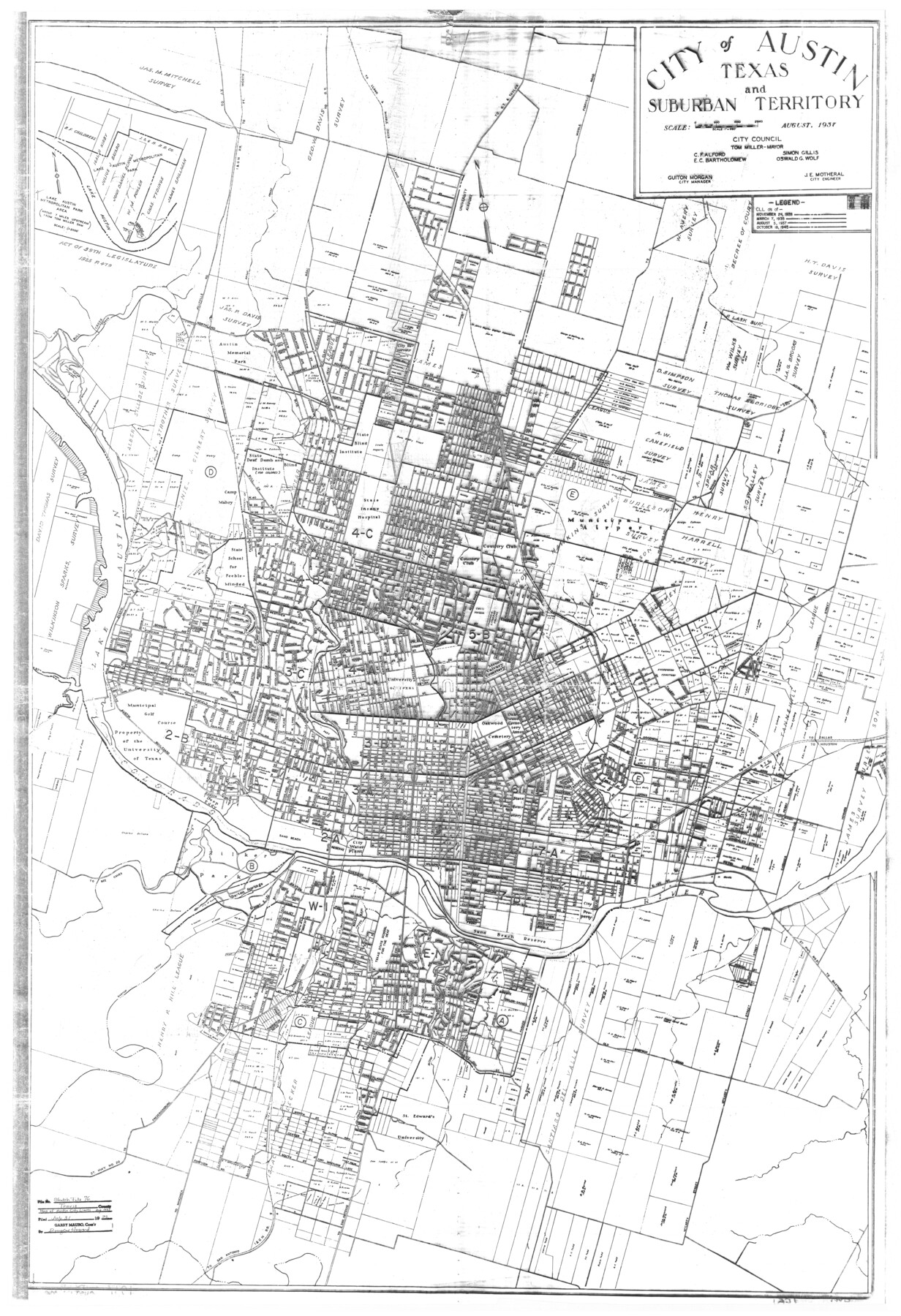
[AG Opinion, memo and city ordinance regarding location of Austin city limits and extent of city ownership of Colorado River bed]
-
Map/Doc
38474
-
Collection
General Map Collection
-
Object Dates
7/31/1996 (Creation Date)
7/31/1996 (File Date)
8/1937 (Creation Date)
7/31/1996 (Correspondence Date)
10/2/1951 (Correspondence Date)
-
Counties
Travis
-
Subjects
Surveying Sketch File
-
Height x Width
11.4 x 8.9 inches
29.0 x 22.6 cm
-
Medium
paper, print
-
Features
Dawson Addition
Johnson Addition
Tobin Addition
Forrest Avenue
Walsh Place
Austin Dam
Rabb Home
Barton Springs Addition
McKinney Avenue
Evergreen Heights
Leland Street
J.E. Bouldin Addition
Exposition Boulevard
Davis Addition
S. 1st Street
Bouldin Creek
Breckenridge Road
Live Oak Grove Addition
Wilson Street
Grand Courts
Post Road
Pleasant View Addition
Blum Creek
Burleson Road
Staehely Addition
A&NW
MP
Southern Pacific Railroad Company
I&GN
MK&TE
H&TC
I&GN
Chestnut Street
Manor Road
Earnest Avenue
42nd Street
Travis Heights
Spreckles Addition
Ridgetop Annex
Guadalupe Street
Alta Vista Addition
Morningside Avenue
45th Street
Alice Avenue
Lewis Hancock Subdivision
Military Heights
Burns Street
Westfield Addition
State Blind Institute
Oakwood Cemetery Annex
State Cemetery
Bethany Cemetery
Evergreen Cemetery
Mount Calvary Cemetery
University of Texas
Municipal Golf Course
Lake Austin
Camp Mabry
State Deaf, Dumb & Blind Institute (for Colored)
Austin Memorial Park Cemetery
Tillotson Institute
Georgetown Road
Cameron Road
Little Walnut Creek
Bull Creek
[Road] to Bull Creek
Lake Austin Metropolitan Park
Lake Austin
University Airport
Middle Fiskville Road
Road to G[eorge]t[own] & Taylor
Road to G[eorge]t[own]
Road to Manchaca
Bellevue Park Addition
Summit Street
Govalle
Webberville Road
Rosewood Avenue
E. 12th Street
E. 19th Street
Rosewood Avenue
Manor Road
Austin Memorial Park Cemetery
St. Edward's University
Road to Jollyville
State Hwy. 20 to Fredericksburg
Barton Creek
Texas State School for the Deaf
Old Bastrop Road
State Hiway [sic] 21 to Bastrop
Barton Springs
Road to Bee Caves
Zilker Park
Deep Eddy
Colorado River
Part of: General Map Collection
Eastland County Rolled Sketch 24

Print $20.00
- Digital $50.00
Eastland County Rolled Sketch 24
1983
Size 33.5 x 38.0 inches
Map/Doc 8830
Nueces County Rolled Sketch 87

Print $20.00
- Digital $50.00
Nueces County Rolled Sketch 87
1983
Size 24.2 x 36.9 inches
Map/Doc 6989
Maps of Gulf Intracoastal Waterway, Texas - Sabine River to the Rio Grande and connecting waterways including ship channels

Print $20.00
- Digital $50.00
Maps of Gulf Intracoastal Waterway, Texas - Sabine River to the Rio Grande and connecting waterways including ship channels
1966
Size 15.6 x 22.0 inches
Map/Doc 61984
Tyler County Sketch File 9

Print $4.00
- Digital $50.00
Tyler County Sketch File 9
Size 8.6 x 6.7 inches
Map/Doc 38644
Coryell County Working Sketch 31

Print $4.00
- Digital $50.00
Coryell County Working Sketch 31
2008
Size 21.8 x 20.6 inches
Map/Doc 88735
Roberts County Working Sketch 13

Print $20.00
- Digital $50.00
Roberts County Working Sketch 13
1971
Size 20.2 x 16.0 inches
Map/Doc 63539
Flight Mission No. CUG-1P, Frame 50, Kleberg County

Print $20.00
- Digital $50.00
Flight Mission No. CUG-1P, Frame 50, Kleberg County
1956
Size 18.6 x 22.3 inches
Map/Doc 86128
Crane County Rolled Sketch 20

Print $20.00
- Digital $50.00
Crane County Rolled Sketch 20
Size 44.5 x 34.6 inches
Map/Doc 8684

La Salle County Working Sketch 17

Print $20.00
- Digital $50.00
La Salle County Working Sketch 17
1936
Size 16.7 x 19.9 inches
Map/Doc 70318
Austin County Sketch File 1

Print $4.00
- Digital $50.00
Austin County Sketch File 1
Size 8.0 x 6.5 inches
Map/Doc 13853
Baylor County Boundary File 3

Print $52.00
- Digital $50.00
Baylor County Boundary File 3
Size 23.2 x 4.9 inches
Map/Doc 50372
You may also like
Panola County Working Sketch 30

Print $20.00
- Digital $50.00
Panola County Working Sketch 30
1981
Map/Doc 71439
Free & Williams Subdivision of the north half of Outlots 56 and 57

Print $20.00
- Digital $50.00
Free & Williams Subdivision of the north half of Outlots 56 and 57
Size 10.9 x 29.5 inches
Map/Doc 475
Leon County Texas

Print $20.00
- Digital $50.00
Leon County Texas
1896
Size 25.4 x 22.1 inches
Map/Doc 3806
Palo Pinto County Sketch File 4

Print $4.00
- Digital $50.00
Palo Pinto County Sketch File 4
1870
Size 8.2 x 12.9 inches
Map/Doc 33394
Flight Mission No. BRE-1P, Frame 56, Nueces County

Print $20.00
- Digital $50.00
Flight Mission No. BRE-1P, Frame 56, Nueces County
1956
Size 18.5 x 22.4 inches
Map/Doc 86645
Aransas County Boundary File 5a

Print $14.00
- Digital $50.00
Aransas County Boundary File 5a
Size 11.3 x 8.7 inches
Map/Doc 49796
Carte Generale du Royaume de la Nouvelle Espagne depuis le Parallele de 16° jusqu'au Parallele de 38° (Latitude Nord)

Print $20.00
- Digital $50.00
Carte Generale du Royaume de la Nouvelle Espagne depuis le Parallele de 16° jusqu'au Parallele de 38° (Latitude Nord)
1804
Size 41.5 x 29.5 inches
Map/Doc 96510
Hunt County Sketch File 9

Print $3.00
- Digital $50.00
Hunt County Sketch File 9
1851
Size 10.0 x 14.8 inches
Map/Doc 27099
Sylvan Sanders Survey Section 20, Block A

Print $20.00
- Digital $50.00
Sylvan Sanders Survey Section 20, Block A
1952
Size 37.0 x 25.1 inches
Map/Doc 92722
Presidio County Rolled Sketch 131B

Print $20.00
- Digital $50.00
Presidio County Rolled Sketch 131B
1993
Size 33.4 x 46.7 inches
Map/Doc 9803
Engineer's Office, Department of the Gulf Map No. 59, Texas prepared by order of Maj. Gen. N. P. Banks under direction of Capt. P. C. Hains, U. S. Engr. & Chief Engr., Dept. of the Gulf

Print $20.00
- Digital $50.00
Engineer's Office, Department of the Gulf Map No. 59, Texas prepared by order of Maj. Gen. N. P. Banks under direction of Capt. P. C. Hains, U. S. Engr. & Chief Engr., Dept. of the Gulf
1865
Size 18.2 x 27.5 inches
Map/Doc 72718
Jim Hogg County Working Sketch 7

Print $20.00
- Digital $50.00
Jim Hogg County Working Sketch 7
1964
Size 20.0 x 18.6 inches
Map/Doc 66593