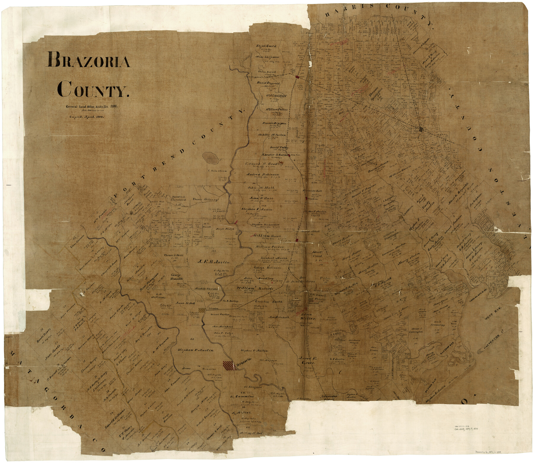
Brazoria County
-
Map/Doc
4890
-
Collection
General Map Collection
-
Object Dates
1891 (Creation Date)
-
Counties
Brazoria
-
Subjects
County
-
Height x Width
47.1 x 54.2 inches
119.6 x 137.7 cm
-
Comments
Copied in April 1899.
Part of: General Map Collection
Travis County Sketch File 15

Print $4.00
- Digital $50.00
Travis County Sketch File 15
Size 12.8 x 8.1 inches
Map/Doc 38310
Terrell County Sketch File 16

Print $24.00
- Digital $50.00
Terrell County Sketch File 16
1902
Size 12.1 x 8.8 inches
Map/Doc 37924

Flight Mission No. CUG-1P, Frame 43, Kleberg County

Print $20.00
- Digital $50.00
Flight Mission No. CUG-1P, Frame 43, Kleberg County
1956
Size 18.6 x 22.4 inches
Map/Doc 86121
Pecos County Rolled Sketch 118

Print $20.00
- Digital $50.00
Pecos County Rolled Sketch 118
1941
Size 42.0 x 30.3 inches
Map/Doc 7260
Maverick County Sketch File 10a

Print $19.00
- Digital $50.00
Maverick County Sketch File 10a
1878
Size 15.4 x 10.0 inches
Map/Doc 31083
Colorado County Sketch File 20

Print $6.00
- Digital $50.00
Colorado County Sketch File 20
Size 6.0 x 7.6 inches
Map/Doc 18954
Nueces County Sketch File 52

Print $10.00
- Digital $50.00
Nueces County Sketch File 52
1947
Size 14.1 x 8.6 inches
Map/Doc 32858
The University of Texas at Austin

The University of Texas at Austin
Size 16.0 x 17.1 inches
Map/Doc 94388
Tarrant County Working Sketch 3

Print $20.00
- Digital $50.00
Tarrant County Working Sketch 3
1948
Size 26.3 x 24.9 inches
Map/Doc 62420
Baylor County Boundary File 7

Print $6.00
- Digital $50.00
Baylor County Boundary File 7
Size 11.2 x 8.8 inches
Map/Doc 50403
Flight Mission No. DAG-22K, Frame 85, Matagorda County

Print $20.00
- Digital $50.00
Flight Mission No. DAG-22K, Frame 85, Matagorda County
1953
Size 15.7 x 15.4 inches
Map/Doc 86469
You may also like
Upshur County Working Sketch 12

Print $20.00
- Digital $50.00
Upshur County Working Sketch 12
1984
Size 31.9 x 29.6 inches
Map/Doc 69569
Hall County Sketch File 4

Print $6.00
- Digital $50.00
Hall County Sketch File 4
Size 14.2 x 9.3 inches
Map/Doc 24800
Val Verde County Rolled Sketch JR

Print $20.00
- Digital $50.00
Val Verde County Rolled Sketch JR
1938
Size 35.9 x 31.1 inches
Map/Doc 10080
Midland County Sketch File 3

Print $20.00
- Digital $50.00
Midland County Sketch File 3
1886
Size 18.3 x 25.2 inches
Map/Doc 12081
Webb County Rolled Sketch 19

Print $40.00
- Digital $50.00
Webb County Rolled Sketch 19
1928
Size 27.9 x 53.7 inches
Map/Doc 10119
Jim Hogg County Boundary File 1

Print $16.00
- Digital $50.00
Jim Hogg County Boundary File 1
Size 11.4 x 8.8 inches
Map/Doc 55519
Crockett County Rolled Sketch 79

Print $40.00
- Digital $50.00
Crockett County Rolled Sketch 79
1954
Size 37.3 x 48.3 inches
Map/Doc 8724
United States of America, compiled from the latest & best authorities by John Melish, 1820

Print $20.00
- Digital $50.00
United States of America, compiled from the latest & best authorities by John Melish, 1820
1820
Size 16.7 x 20.2 inches
Map/Doc 89220
Mrs. R. L. Westerman Subdivision of 2 1/2 Acres out of North Half of Survey Number 1, Block Number 36, Township 5 North. Dawson County, Texas

Print $20.00
- Digital $50.00
Mrs. R. L. Westerman Subdivision of 2 1/2 Acres out of North Half of Survey Number 1, Block Number 36, Township 5 North. Dawson County, Texas
1924
Size 18.6 x 24.5 inches
Map/Doc 92591
[Brooks & Burleson Blocks 2 and 4, Capitol Leagues and other surveys and Blocks in vicinity]
![90645, [Brooks & Burleson Blocks 2 and 4, Capitol Leagues and other surveys and Blocks in vicinity], Twichell Survey Records](https://historictexasmaps.com/wmedia_w700/maps/90645-1.tif.jpg)
Print $20.00
- Digital $50.00
[Brooks & Burleson Blocks 2 and 4, Capitol Leagues and other surveys and Blocks in vicinity]
1903
Size 22.6 x 35.6 inches
Map/Doc 90645
Flight Mission No. CRC-3R, Frame 21, Chambers County

Print $20.00
- Digital $50.00
Flight Mission No. CRC-3R, Frame 21, Chambers County
1956
Size 18.6 x 22.2 inches
Map/Doc 84795
Flight Mission No. DIX-7P, Frame 13, Aransas County

Print $20.00
- Digital $50.00
Flight Mission No. DIX-7P, Frame 13, Aransas County
1956
Size 4.0 x 5.0 inches
Map/Doc 83865