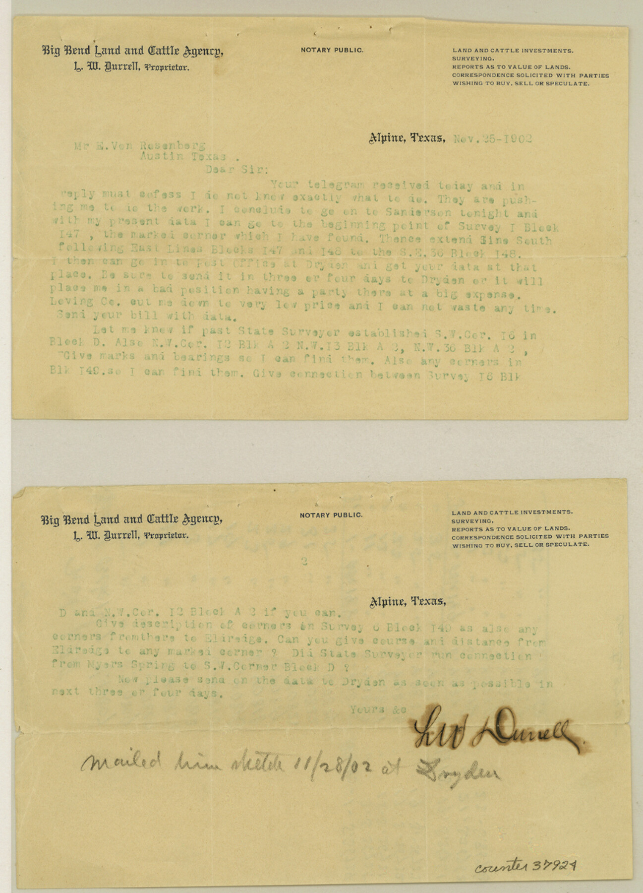
Terrell County Sketch File 16
[Correspondence regarding Blocks 147, 148, and 149 and adjacent surveys to the east]
-
Map/Doc
37924
-
Collection
General Map Collection
-
Object Dates
1902 (Creation Date)
-
People and Organizations
L.W. Durrell (Surveyor/Engineer)
George B. Loving (Agent)
-
Counties
Terrell
-
Subjects
Surveying Sketch File
-
Height x Width
12.1 x 8.8 inches
30.7 x 22.4 cm
-
Medium
multi-page, multi-format
-
Features
Myers Spring
Old Military Road
Part of: General Map Collection
Comanche County Sketch File 27

Print $22.00
- Digital $50.00
Comanche County Sketch File 27
1912
Size 9.4 x 7.1 inches
Map/Doc 19116
Atascosa County Working Sketch 10

Print $20.00
- Digital $50.00
Atascosa County Working Sketch 10
1919
Size 26.2 x 22.3 inches
Map/Doc 67206
San Antonio - Downtown - Riverwalk

San Antonio - Downtown - Riverwalk
Size 11.8 x 17.9 inches
Map/Doc 94289
Van Zandt County Sketch File 7

Print $8.00
- Digital $50.00
Van Zandt County Sketch File 7
1849
Size 5.2 x 7.4 inches
Map/Doc 39375
McMullen County Rolled Sketch 23

Print $20.00
- Digital $50.00
McMullen County Rolled Sketch 23
2020
Size 24.5 x 36.3 inches
Map/Doc 95949
Crockett County Rolled Sketch 52

Print $20.00
- Digital $50.00
Crockett County Rolled Sketch 52
Size 36.7 x 44.7 inches
Map/Doc 8715
Trinity River, Wildcat Ferry Sheet

Print $20.00
- Digital $50.00
Trinity River, Wildcat Ferry Sheet
1928
Size 41.5 x 40.9 inches
Map/Doc 65182
Flight Mission No. DIX-6P, Frame 120, Aransas County

Print $20.00
- Digital $50.00
Flight Mission No. DIX-6P, Frame 120, Aransas County
1956
Size 18.7 x 22.2 inches
Map/Doc 83826
Nolan County Rolled Sketch 2

Print $20.00
- Digital $50.00
Nolan County Rolled Sketch 2
1956
Size 27.7 x 35.0 inches
Map/Doc 6860
Matagorda County NRC Article 33.136 Sketch 21

Print $42.00
Matagorda County NRC Article 33.136 Sketch 21
2025
Map/Doc 97429
Bell County Sketch File 7

Print $40.00
- Digital $50.00
Bell County Sketch File 7
1850
Size 15.8 x 12.5 inches
Map/Doc 14375
South Sulphur River, Charleston Sheet

Print $4.00
- Digital $50.00
South Sulphur River, Charleston Sheet
1924
Size 29.4 x 29.5 inches
Map/Doc 65168
You may also like
Sterling County

Print $20.00
- Digital $50.00
Sterling County
1926
Size 47.8 x 35.2 inches
Map/Doc 16820
Rockwall County Boundary File 52a

Print $22.00
- Digital $50.00
Rockwall County Boundary File 52a
Size 12.9 x 8.3 inches
Map/Doc 58461
Roberts County Working Sketch 32

Print $20.00
- Digital $50.00
Roberts County Working Sketch 32
1978
Size 26.6 x 22.5 inches
Map/Doc 63558
[Blocks T1, T2, T3, S3, A, O5, and Capitol Leagues in Northwest Lamb County and Southwest Castro County]
![91005, [Blocks T1, T2, T3, S3, A, O5, and Capitol Leagues in Northwest Lamb County and Southwest Castro County], Twichell Survey Records](https://historictexasmaps.com/wmedia_w700/maps/91005-1.tif.jpg)
Print $20.00
- Digital $50.00
[Blocks T1, T2, T3, S3, A, O5, and Capitol Leagues in Northwest Lamb County and Southwest Castro County]
Size 30.3 x 34.0 inches
Map/Doc 91005
![4781, Coke Co[unty], General Map Collection](https://historictexasmaps.com/wmedia_w700/maps/4781.tif.jpg)
Map of the Fort Worth & Denver City Railway

Print $40.00
- Digital $50.00
Map of the Fort Worth & Denver City Railway
1887
Size 22.8 x 124.4 inches
Map/Doc 64458
Yellowhouse Addition to Littlefield, Texas Located on Labors 12 & 13 Capitol League 664

Print $20.00
- Digital $50.00
Yellowhouse Addition to Littlefield, Texas Located on Labors 12 & 13 Capitol League 664
1925
Size 26.9 x 26.7 inches
Map/Doc 92402
Polk County Sketch File 11

Print $4.00
- Digital $50.00
Polk County Sketch File 11
Size 9.2 x 8.1 inches
Map/Doc 34142
Map of Marion County

Print $20.00
- Digital $50.00
Map of Marion County
1920
Size 29.2 x 43.2 inches
Map/Doc 66916
Shackelford County Working Sketch 8

Print $20.00
- Digital $50.00
Shackelford County Working Sketch 8
1973
Size 31.9 x 28.7 inches
Map/Doc 63848
Mineral Plats - Brewster, Culberson and Duval

Mineral Plats - Brewster, Culberson and Duval
Map/Doc 81745
Live Oak County Working Sketch 4

Print $20.00
- Digital $50.00
Live Oak County Working Sketch 4
1914
Size 16.8 x 14.0 inches
Map/Doc 70589