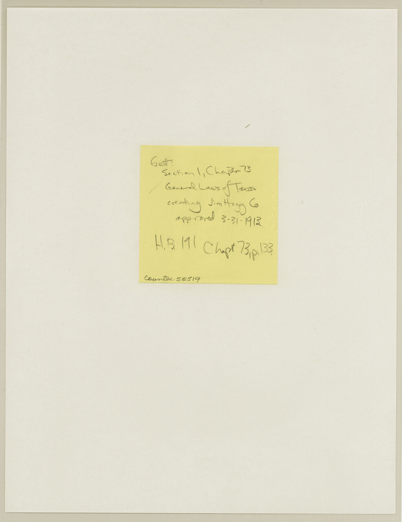
Jim Hogg County Boundary File 1
[General Law concerning Boundary lines of Duval and Jim Hogg Counties]
-
Map/Doc
55519
-
Collection
General Map Collection
-
Counties
Jim Hogg
-
Subjects
County Boundaries
-
Height x Width
11.4 x 8.8 inches
29.0 x 22.4 cm
Part of: General Map Collection
Survey of The Rio Grande Roma to the Gulf of Mexico

Survey of The Rio Grande Roma to the Gulf of Mexico
Map/Doc 81739
Bandera County Working Sketch 5

Print $3.00
- Digital $50.00
Bandera County Working Sketch 5
1915
Size 12.0 x 9.0 inches
Map/Doc 67598
Travis County Rolled Sketch 15

Print $20.00
- Digital $50.00
Travis County Rolled Sketch 15
1939
Size 25.4 x 37.6 inches
Map/Doc 10011
Classification of Blocks 1 to 58, Set Apart to University by Constitution of 1876 by M. B. Moore

Classification of Blocks 1 to 58, Set Apart to University by Constitution of 1876 by M. B. Moore
Map/Doc 81726
Fayette County Boundary File 8

Print $19.00
- Digital $50.00
Fayette County Boundary File 8
Size 14.4 x 9.0 inches
Map/Doc 53402
Crockett County Rolled Sketch 49

Print $20.00
- Digital $50.00
Crockett County Rolled Sketch 49
1940
Size 32.8 x 42.7 inches
Map/Doc 8713
Jefferson Co.

Print $20.00
- Digital $50.00
Jefferson Co.
1918
Size 46.7 x 40.8 inches
Map/Doc 16860
[University Lands in West Texas]
![2422, [University Lands in West Texas], General Map Collection](https://historictexasmaps.com/wmedia_w700/maps/2422.tif.jpg)
Print $20.00
- Digital $50.00
[University Lands in West Texas]
1938
Size 20.3 x 28.1 inches
Map/Doc 2422
Sketch of Sabine Lake and Pass

Print $20.00
- Digital $50.00
Sketch of Sabine Lake and Pass
1840
Size 24.8 x 18.2 inches
Map/Doc 72725
La Salle County Working Sketch 2

Print $20.00
- Digital $50.00
La Salle County Working Sketch 2
1886
Size 17.6 x 16.0 inches
Map/Doc 70303
Trinity River, Boyd Crossing Sheet/Chambers Creek

Print $20.00
- Digital $50.00
Trinity River, Boyd Crossing Sheet/Chambers Creek
1931
Size 17.5 x 43.1 inches
Map/Doc 65238
Flight Mission No. CGI-3N, Frame 66, Cameron County

Print $20.00
- Digital $50.00
Flight Mission No. CGI-3N, Frame 66, Cameron County
1954
Size 18.6 x 22.1 inches
Map/Doc 84560
You may also like

Map of Titus County

Print $20.00
- Digital $50.00
Map of Titus County
1879
Size 23.3 x 14.7 inches
Map/Doc 4082
Houston County Sketch File 40

Print $40.00
- Digital $50.00
Houston County Sketch File 40
Size 16.3 x 12.1 inches
Map/Doc 26826
Guadalupe County Working Sketch 10

Print $20.00
- Digital $50.00
Guadalupe County Working Sketch 10
1966
Size 21.2 x 27.2 inches
Map/Doc 63319
Mrs. Alex A. Slaughter Ranch Hockley County, Texas

Print $20.00
- Digital $50.00
Mrs. Alex A. Slaughter Ranch Hockley County, Texas
Size 26.2 x 19.7 inches
Map/Doc 92237
Menard County Working Sketch 29

Print $6.00
- Digital $50.00
Menard County Working Sketch 29
1967
Size 25.8 x 32.0 inches
Map/Doc 70976
Bailey County Sketch File 1

Print $40.00
- Digital $50.00
Bailey County Sketch File 1
1882
Size 15.8 x 15.3 inches
Map/Doc 10880
Wise County Sketch File 12

Print $20.00
- Digital $50.00
Wise County Sketch File 12
1854
Size 13.4 x 19.0 inches
Map/Doc 12699
Jeff Davis County Boundary File 2

Print $14.00
- Digital $50.00
Jeff Davis County Boundary File 2
Size 14.3 x 8.8 inches
Map/Doc 55505
Flight Mission No. BRA-16M, Frame 138, Jefferson County

Print $20.00
- Digital $50.00
Flight Mission No. BRA-16M, Frame 138, Jefferson County
1953
Size 18.7 x 22.3 inches
Map/Doc 85744
Brazos River, Washington Sheet

Print $6.00
- Digital $50.00
Brazos River, Washington Sheet
1936
Size 30.4 x 24.7 inches
Map/Doc 65277
Flight Mission No. CRC-4R, Frame 149, Chambers County

Print $20.00
- Digital $50.00
Flight Mission No. CRC-4R, Frame 149, Chambers County
1956
Size 18.7 x 22.4 inches
Map/Doc 84912