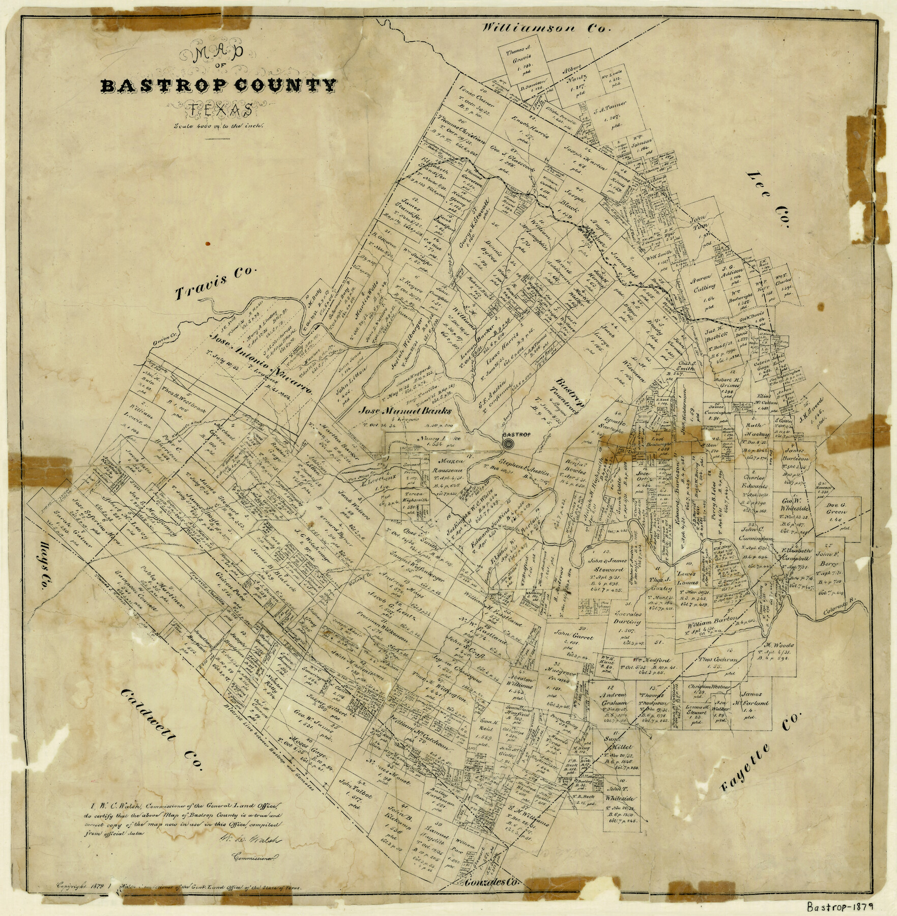
Map of Bastrop County, Texas
-
Map/Doc
4507
-
Collection
General Map Collection
-
Object Dates
1879 (Creation Date)
-
People and Organizations
W.C. Walsh (GLO Commissioner)
-
Counties
Bastrop
-
Subjects
County
-
Height x Width
24.6 x 24.1 inches
62.5 x 61.2 cm
-
Comments
Copyrighted 1879.
-
Features
Pin Oak Creek
Peach Creek
Colorado River
Turner Creek
Walnut Creek
Mohard Creek
Alumen [sic] Creek
Ten Miles Creek
Copperas Creek
Buckner Creek
Buffalo Creek
McDade
Dry Fork of Pin Oak Creek
Piney Creek
Bastrop
West Fork of Walnut Creek
Onion Creek
Cedar Creek
Wilbarger Creek
Sandy Creek
West Fork of Sandy Creek
H&TC
Part of: General Map Collection
Sabine River, Rocky Ford Crossing Sheet/Cowleach Fork of the Sabine River

Print $20.00
- Digital $50.00
Sabine River, Rocky Ford Crossing Sheet/Cowleach Fork of the Sabine River
1936
Size 38.9 x 29.2 inches
Map/Doc 65144
Uvalde County Working Sketch 43

Print $20.00
- Digital $50.00
Uvalde County Working Sketch 43
1978
Size 29.3 x 27.7 inches
Map/Doc 72113
Galveston County Sketch File 5a

Print $4.00
- Digital $50.00
Galveston County Sketch File 5a
1847
Size 12.6 x 8.2 inches
Map/Doc 23360
Panola County Sketch File 5

Print $4.00
- Digital $50.00
Panola County Sketch File 5
1860
Size 8.3 x 5.6 inches
Map/Doc 33453
Hutchinson County Rolled Sketch 40

Print $20.00
- Digital $50.00
Hutchinson County Rolled Sketch 40
1981
Size 25.7 x 37.3 inches
Map/Doc 6304
Winkler County Working Sketch 18

Print $40.00
- Digital $50.00
Winkler County Working Sketch 18
1980
Size 33.7 x 49.9 inches
Map/Doc 72612
United States - Gulf Coast - Galveston to Rio Grande

Print $20.00
- Digital $50.00
United States - Gulf Coast - Galveston to Rio Grande
1940
Size 27.1 x 18.2 inches
Map/Doc 72758
Map of the Mississippi River from its Source to the Mouth of the Missouri

Print $20.00
- Digital $50.00
Map of the Mississippi River from its Source to the Mouth of the Missouri
1810
Size 10.4 x 31.3 inches
Map/Doc 95153
Intracoastal Waterway in Texas - Corpus Christi to Point Isabel including Arroyo Colorado to Mo. Pac. R.R. Bridge Near Harlingen

Print $20.00
- Digital $50.00
Intracoastal Waterway in Texas - Corpus Christi to Point Isabel including Arroyo Colorado to Mo. Pac. R.R. Bridge Near Harlingen
1933
Size 40.6 x 28.0 inches
Map/Doc 61877
Roberts County Rolled Sketch 5

Print $20.00
- Digital $50.00
Roberts County Rolled Sketch 5
2015
Size 42.6 x 25.0 inches
Map/Doc 94071
Cottle County Sketch File 7

Print $20.00
- Digital $50.00
Cottle County Sketch File 7
1893
Size 22.1 x 20.7 inches
Map/Doc 11191
Culberson County Working Sketch 79

Print $20.00
- Digital $50.00
Culberson County Working Sketch 79
1976
Size 30.9 x 30.6 inches
Map/Doc 68533
You may also like
Brooks County Rolled Sketch 17

Print $20.00
- Digital $50.00
Brooks County Rolled Sketch 17
1941
Size 30.8 x 36.5 inches
Map/Doc 8532
Coryell County Sketch File 5

Print $40.00
- Digital $50.00
Coryell County Sketch File 5
1858
Size 16.0 x 12.7 inches
Map/Doc 19345
Map of Erath County

Print $20.00
- Digital $50.00
Map of Erath County
1872
Size 20.2 x 19.8 inches
Map/Doc 3521
Brewster County Sketch File 14

Print $26.00
- Digital $50.00
Brewster County Sketch File 14
Size 11.2 x 8.8 inches
Map/Doc 15746
Map of Mexico, including Yucatan & Upper California, exhibiting the chief cities and towns, the principal travelling routes &c.

Print $20.00
- Digital $50.00
Map of Mexico, including Yucatan & Upper California, exhibiting the chief cities and towns, the principal travelling routes &c.
1846
Size 18.3 x 26.1 inches
Map/Doc 93871
Medina County Working Sketch 17

Print $20.00
- Digital $50.00
Medina County Working Sketch 17
1979
Size 26.8 x 34.5 inches
Map/Doc 70932
Travis County Working Sketch 16

Print $20.00
- Digital $50.00
Travis County Working Sketch 16
1941
Size 17.8 x 20.5 inches
Map/Doc 69400
Maps of Gulf Intracoastal Waterway, Texas - Sabine River to the Rio Grande and connecting waterways including ship channels

Print $20.00
- Digital $50.00
Maps of Gulf Intracoastal Waterway, Texas - Sabine River to the Rio Grande and connecting waterways including ship channels
1966
Size 14.5 x 22.2 inches
Map/Doc 61972
Map of Llano County Showing Geology, Mineral Localities, Topography, etc.

Print $20.00
Map of Llano County Showing Geology, Mineral Localities, Topography, etc.
1875
Size 16.5 x 21.3 inches
Map/Doc 88969
Galveston County NRC Article 33.136 Sketch 81

Print $202.00
- Digital $50.00
Galveston County NRC Article 33.136 Sketch 81
2015
Size 34.0 x 22.0 inches
Map/Doc 94976
Reeves County Rolled Sketch 24

Print $20.00
- Digital $50.00
Reeves County Rolled Sketch 24
1982
Size 40.6 x 28.4 inches
Map/Doc 7492
Topographical Map of the Rio Grande from Roma to the Gulf of Mexico, Index Map, Sheet No. 1

Print $20.00
- Digital $50.00
Topographical Map of the Rio Grande from Roma to the Gulf of Mexico, Index Map, Sheet No. 1
1912
Map/Doc 89523