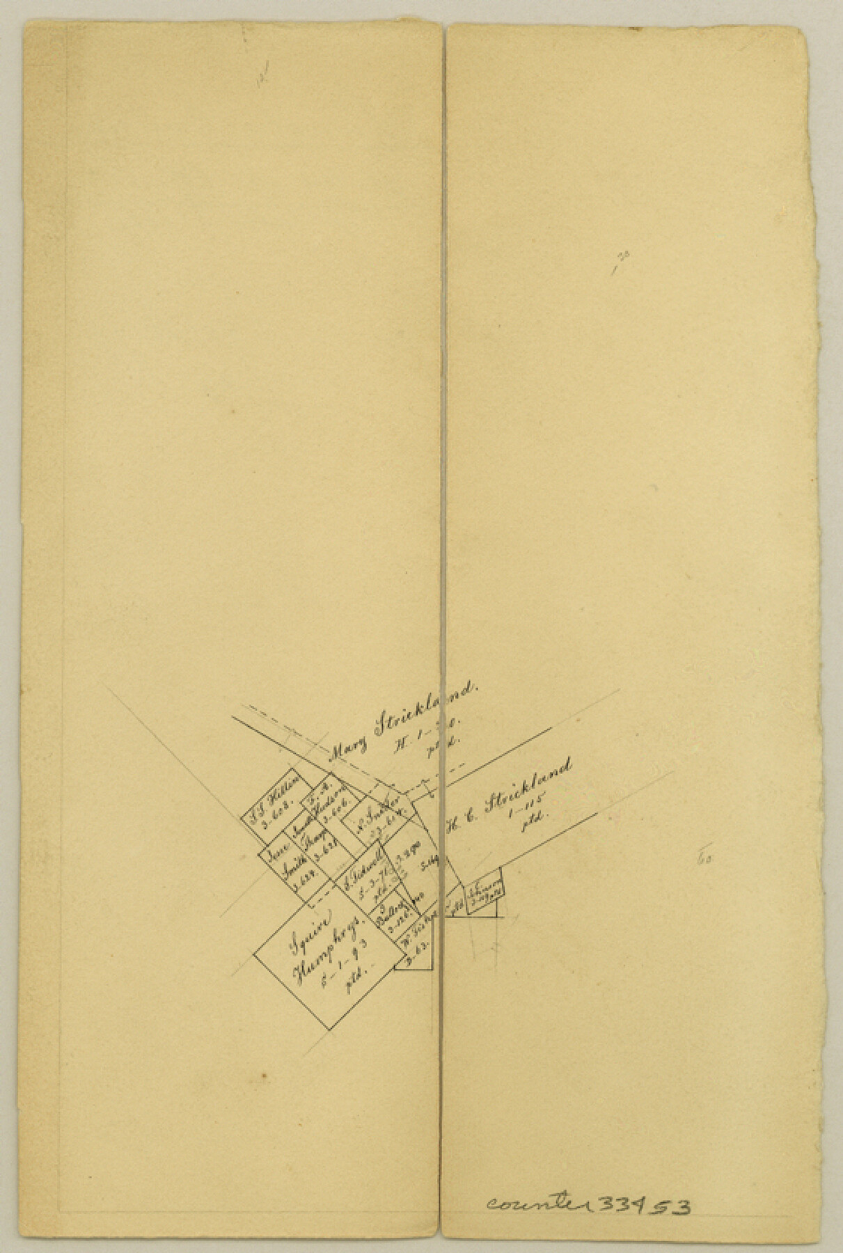
Panola County Sketch File 5
[Sketch in the southwest part of the county]
-
Map/Doc
33453
-
Collection
General Map Collection
-
Object Dates
9/21/1860 (Creation Date)
9/21/1860 (File Date)
-
People and Organizations
W. Rosenberg (Surveyor/Engineer)
-
Counties
Panola Shelby
-
Subjects
Surveying Sketch File
-
Height x Width
8.3 x 5.6 inches
21.1 x 14.2 cm
-
Medium
paper, manuscript
Part of: General Map Collection
Gonzales County Sketch File 3

Print $24.00
- Digital $50.00
Gonzales County Sketch File 3
1871
Size 12.6 x 8.3 inches
Map/Doc 24361
Edwards County Rolled Sketch 33

Print $20.00
- Digital $50.00
Edwards County Rolled Sketch 33
1890
Size 25.0 x 25.8 inches
Map/Doc 5815
Concho County Sketch File 33

Print $20.00
- Digital $50.00
Concho County Sketch File 33
1926
Size 13.4 x 18.1 inches
Map/Doc 11158
Flight Mission No. DCL-5C, Frame 2, Kenedy County

Print $20.00
- Digital $50.00
Flight Mission No. DCL-5C, Frame 2, Kenedy County
1943
Size 18.5 x 22.5 inches
Map/Doc 85827
Galveston County NRC Article 33.136 Sketch 25

Print $26.00
- Digital $50.00
Galveston County NRC Article 33.136 Sketch 25
1999
Size 36.0 x 23.9 inches
Map/Doc 81906
Hardin County Working Sketch 41

Print $20.00
- Digital $50.00
Hardin County Working Sketch 41
Size 35.1 x 40.0 inches
Map/Doc 63440
Coast Chart No. 210 Aransas Pass and Corpus Christi Bay with the coast to latitude 27° 12' Texas

Print $20.00
- Digital $50.00
Coast Chart No. 210 Aransas Pass and Corpus Christi Bay with the coast to latitude 27° 12' Texas
1887
Size 27.2 x 18.2 inches
Map/Doc 72801
Pecos County Rolled Sketch 163

Print $20.00
- Digital $50.00
Pecos County Rolled Sketch 163
Size 28.2 x 23.9 inches
Map/Doc 7286
Medina County Working Sketch 15

Print $20.00
- Digital $50.00
Medina County Working Sketch 15
1974
Size 26.2 x 18.7 inches
Map/Doc 70930
Harris County Working Sketch 46

Print $20.00
- Digital $50.00
Harris County Working Sketch 46
1942
Size 19.8 x 17.7 inches
Map/Doc 65938
Harris County Working Sketch Graphic Index, Sheet 2 (Sketches 69 to Most Recent)

Print $20.00
- Digital $50.00
Harris County Working Sketch Graphic Index, Sheet 2 (Sketches 69 to Most Recent)
1940
Size 38.5 x 46.2 inches
Map/Doc 76569
Colorado River, LaGrange Sheet

Print $20.00
- Digital $50.00
Colorado River, LaGrange Sheet
1934
Size 37.8 x 32.9 inches
Map/Doc 65302
You may also like
Val Verde County Working Sketch 117

Print $20.00
- Digital $50.00
Val Verde County Working Sketch 117
1993
Size 24.7 x 29.8 inches
Map/Doc 82846
Loving County Working Sketch 21

Print $20.00
- Digital $50.00
Loving County Working Sketch 21
1984
Size 26.7 x 36.0 inches
Map/Doc 70655
[Blocks W, A4, A2, T, D10, B, JD, O, JK4]
![92251, [Blocks W, A4, A2, T, D10, B, JD, O, JK4], Twichell Survey Records](https://historictexasmaps.com/wmedia_w700/maps/92251-1.tif.jpg)
Print $20.00
- Digital $50.00
[Blocks W, A4, A2, T, D10, B, JD, O, JK4]
Size 36.9 x 30.1 inches
Map/Doc 92251

Smith County Rolled Sketch 2

Print $20.00
- Digital $50.00
Smith County Rolled Sketch 2
Size 36.2 x 34.6 inches
Map/Doc 76010
Outer Continental Shelf Leasing Maps (Louisiana Offshore Operations)

Print $20.00
- Digital $50.00
Outer Continental Shelf Leasing Maps (Louisiana Offshore Operations)
1954
Size 21.2 x 16.3 inches
Map/Doc 76103
Scurry County

Print $20.00
- Digital $50.00
Scurry County
1921
Size 39.0 x 36.1 inches
Map/Doc 77419
Val Verde County Sketch File Z20

Print $20.00
- Digital $50.00
Val Verde County Sketch File Z20
1913
Size 11.5 x 9.0 inches
Map/Doc 39153
Flight Mission No. DQO-12K, Frame 36, Galveston County

Print $20.00
- Digital $50.00
Flight Mission No. DQO-12K, Frame 36, Galveston County
1952
Size 18.8 x 22.6 inches
Map/Doc 85227
Lamar County Sketch File 8

Print $20.00
- Digital $50.00
Lamar County Sketch File 8
1895
Size 21.4 x 23.1 inches
Map/Doc 11966
Parker County Sketch File 8

Print $6.00
- Digital $50.00
Parker County Sketch File 8
1859
Size 11.0 x 11.5 inches
Map/Doc 33536
Rusk County Sketch File 6

Print $4.00
Rusk County Sketch File 6
1848
Size 6.3 x 7.9 inches
Map/Doc 35499