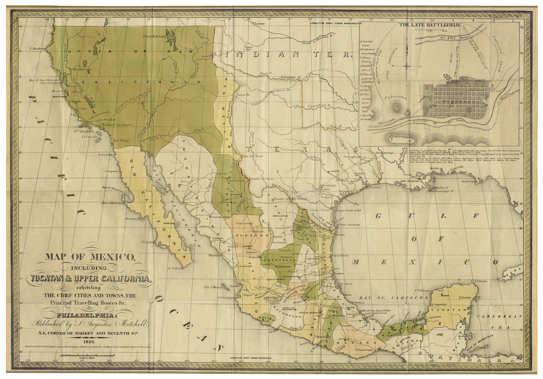
Map of Mexico, including Yucatan & Upper California, exhibiting the chief cities and towns, the principal travelling routes &c.
[Inset:] The Late Battlefield
-
Map/Doc
93871
-
Collection
Holcomb Digital Map Collection
-
Object Dates
1846 (Creation Date)
-
People and Organizations
S. Augustus Mitchell (Publisher)
-
Subjects
Mexico State of Texas
-
Height x Width
18.3 x 26.1 inches
46.5 x 66.3 cm
-
Comments
Courtesy of Frank and Carol Holcomb.
Part of: Holcomb Digital Map Collection
Americae Sive Novi Orbis Nova Descriptio

Print $20.00
- Digital $50.00
Americae Sive Novi Orbis Nova Descriptio
1606
Size 16.5 x 22.4 inches
Map/Doc 93810
A New Map of Texas with the Contiguous American & Mexican States

Print $20.00
- Digital $50.00
A New Map of Texas with the Contiguous American & Mexican States
1837
Size 12.5 x 15.1 inches
Map/Doc 96643
Amèrica noviter delineata

Print $20.00
- Digital $50.00
Amèrica noviter delineata
1630
Size 21.5 x 24.7 inches
Map/Doc 93814

A Map of the United States of Mexico as organized and defined by the several Acts of the Congress of that Republic

Print $20.00
- Digital $50.00
A Map of the United States of Mexico as organized and defined by the several Acts of the Congress of that Republic
1847
Size 24.3 x 30.6 inches
Map/Doc 93876


Map of the United States of America with its territories and districts including also a part of upper and lower Canada and Mexico

Print $20.00
- Digital $50.00
Map of the United States of America with its territories and districts including also a part of upper and lower Canada and Mexico
1835
Size 31.3 x 44.7 inches
Map/Doc 93852
Karte des Staates, Texas

Print $20.00
- Digital $50.00
Karte des Staates, Texas
1851
Size 17.8 x 19.9 inches
Map/Doc 97191
The History of Texas; or, the Emigrants, Farmer's, and Politician's Guide to the Character, Climate, Soil and Productions of that Country; geographically arranged from personal observation and experience.

Print $692.00
- Digital $50.00
The History of Texas; or, the Emigrants, Farmer's, and Politician's Guide to the Character, Climate, Soil and Productions of that Country; geographically arranged from personal observation and experience.
1836
Size 8.1 x 5.3 inches
Map/Doc 93856
Map of Texas compiled from surveys included in the General Land Office

Print $20.00
- Digital $50.00
Map of Texas compiled from surveys included in the General Land Office
1851
Size 31.4 x 25.3 inches
Map/Doc 94417
Amerique Septentrionale divisée en ses principales parties

Print $20.00
- Digital $50.00
Amerique Septentrionale divisée en ses principales parties
1792
Size 21.3 x 25.9 inches
Map/Doc 93916
You may also like
Harrison County

Print $20.00
- Digital $50.00
Harrison County
1857
Size 20.3 x 21.0 inches
Map/Doc 1116
Controlled Mosaic by Jack Amman Photogrammetric Engineers, Inc - Sheet 43

Print $20.00
- Digital $50.00
Controlled Mosaic by Jack Amman Photogrammetric Engineers, Inc - Sheet 43
1954
Size 20.0 x 24.0 inches
Map/Doc 83502
Shelby County Rolled Sketch 18

Print $20.00
- Digital $50.00
Shelby County Rolled Sketch 18
1975
Size 36.2 x 40.7 inches
Map/Doc 9926
Grayson County

Print $20.00
- Digital $50.00
Grayson County
1935
Size 43.4 x 40.5 inches
Map/Doc 95512
Mississippi River to Galveston

Print $40.00
- Digital $50.00
Mississippi River to Galveston
1976
Size 37.4 x 51.2 inches
Map/Doc 69947
Flight Mission No. DIX-5P, Frame 103, Aransas County

Print $20.00
- Digital $50.00
Flight Mission No. DIX-5P, Frame 103, Aransas County
1956
Size 17.5 x 18.2 inches
Map/Doc 83781
Jefferson County Rolled Sketch 61A

Print $20.00
- Digital $50.00
Jefferson County Rolled Sketch 61A
1928
Size 27.2 x 40.4 inches
Map/Doc 6410
Maps showing Arkansas Central, the Helena & Corinth, and the Pine Bluff & Southwestern Railroads together forming the Texas & Northeastern Railway.

Print $20.00
Maps showing Arkansas Central, the Helena & Corinth, and the Pine Bluff & Southwestern Railroads together forming the Texas & Northeastern Railway.
1872
Size 26.8 x 29.1 inches
Map/Doc 93609
Liberty County Working Sketch 70

Print $20.00
- Digital $50.00
Liberty County Working Sketch 70
1976
Size 32.4 x 30.8 inches
Map/Doc 70530
Edwards County Working Sketch 55

Print $20.00
- Digital $50.00
Edwards County Working Sketch 55
1951
Size 27.1 x 21.6 inches
Map/Doc 68931
Hudspeth County Rolled Sketch 73

Print $40.00
- Digital $50.00
Hudspeth County Rolled Sketch 73
1992
Size 38.9 x 49.3 inches
Map/Doc 9236
Robertson County Sketch File 6

Print $4.00
Robertson County Sketch File 6
1870
Size 8.9 x 7.6 inches
Map/Doc 35362