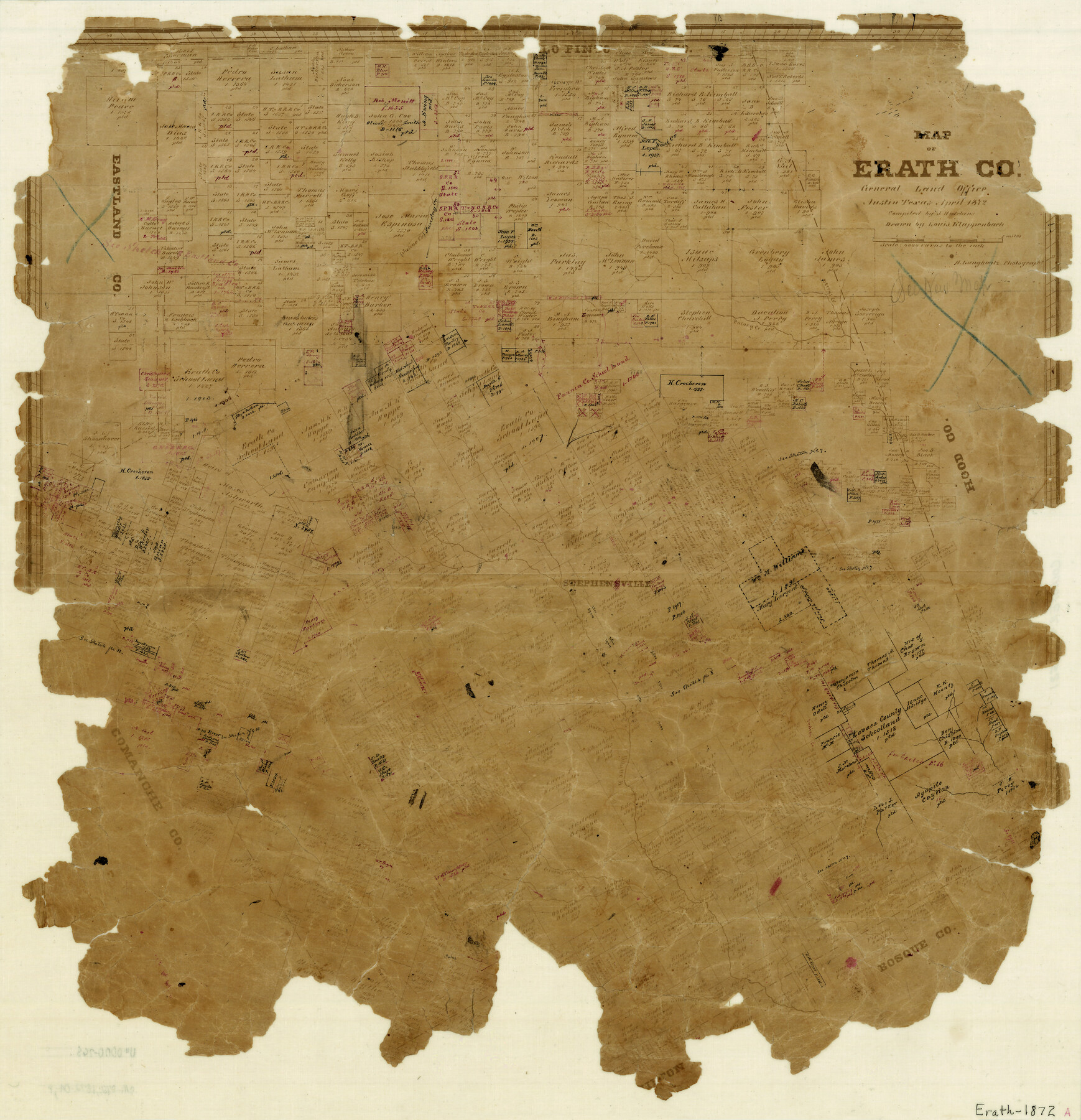
Map of Erath County
-
Map/Doc
3521
-
Collection
General Map Collection
-
Object Dates
4/1872 (Creation Date)
-
People and Organizations
Herman Lungkwitz (Draftsman)
L. Klappenbach (Draftsman)
J.H. Hutchins (Compiler)
-
Counties
Erath
-
Subjects
County
-
Height x Width
20.2 x 19.8 inches
51.3 x 50.3 cm
-
Features
Sunday Creek
Saline Creek
Buck Creek
Berrys Creek
Paloxy Creek
Armstrong Creek
Stephenville
Alarm Creek
Bosque River
Indian Creek
Duffaus Creek
Greens Creek
Resleys Creek
Gillmore [sic] Creek
Part of: General Map Collection
Flight Mission No. CUG-2P, Frame 10, Kleberg County

Print $20.00
- Digital $50.00
Flight Mission No. CUG-2P, Frame 10, Kleberg County
1956
Size 18.7 x 22.3 inches
Map/Doc 86182
Anderson County Rolled Sketch 14

Print $20.00
- Digital $50.00
Anderson County Rolled Sketch 14
1997
Size 30.1 x 36.5 inches
Map/Doc 77159
Map of Jasper County

Print $20.00
- Digital $50.00
Map of Jasper County
1839
Size 40.2 x 28.8 inches
Map/Doc 78407

Harris County Working Sketch 75

Print $20.00
- Digital $50.00
Harris County Working Sketch 75
1964
Size 29.7 x 32.3 inches
Map/Doc 65967
Sabine Bank to East Bay including Heald Bank

Print $20.00
- Digital $50.00
Sabine Bank to East Bay including Heald Bank
1925
Size 44.2 x 34.8 inches
Map/Doc 69844
Crockett County Rolled Sketch 88O

Print $126.00
- Digital $50.00
Crockett County Rolled Sketch 88O
1973
Size 9.8 x 15.1 inches
Map/Doc 44158
Trinity River, Cox Bluff Sheet

Print $20.00
- Digital $50.00
Trinity River, Cox Bluff Sheet
1926
Size 36.0 x 46.2 inches
Map/Doc 65214
Flight Mission No. DQN-2K, Frame 25, Calhoun County

Print $20.00
- Digital $50.00
Flight Mission No. DQN-2K, Frame 25, Calhoun County
1953
Size 18.8 x 22.4 inches
Map/Doc 84232
McMullen County Rolled Sketch 9

Print $20.00
- Digital $50.00
McMullen County Rolled Sketch 9
Size 34.4 x 40.9 inches
Map/Doc 6726
Hays County Sketch File 16

Print $4.00
- Digital $50.00
Hays County Sketch File 16
1857
Size 12.8 x 8.3 inches
Map/Doc 26227
Coleman County Sketch File 50

Print $4.00
- Digital $50.00
Coleman County Sketch File 50
Size 12.6 x 8.2 inches
Map/Doc 18853
You may also like

Pecos County Working Sketch 34

Print $20.00
- Digital $50.00
Pecos County Working Sketch 34
1939
Size 32.7 x 27.6 inches
Map/Doc 71506
Rusk County Sketch File 16

Print $4.00
Rusk County Sketch File 16
1849
Size 13.0 x 8.4 inches
Map/Doc 35518
Kimble County Working Sketch 15

Print $20.00
- Digital $50.00
Kimble County Working Sketch 15
1923
Size 22.4 x 22.1 inches
Map/Doc 70083

Flight Mission No. DAG-23K, Frame 144, Matagorda County

Print $20.00
- Digital $50.00
Flight Mission No. DAG-23K, Frame 144, Matagorda County
1953
Size 17.4 x 22.6 inches
Map/Doc 86492
Cherokee County Sketch File 18

Print $4.00
- Digital $50.00
Cherokee County Sketch File 18
1870
Size 10.2 x 8.1 inches
Map/Doc 18159
Shelby County Rolled Sketch 9

Print $20.00
- Digital $50.00
Shelby County Rolled Sketch 9
Size 23.0 x 19.1 inches
Map/Doc 7777
Copy of Surveyor's Field Book, Morris Browning - In Blocks 7, 5 & 4, I&GNRRCo., Hutchinson and Carson Counties, Texas

Print $2.00
- Digital $50.00
Copy of Surveyor's Field Book, Morris Browning - In Blocks 7, 5 & 4, I&GNRRCo., Hutchinson and Carson Counties, Texas
1888
Size 6.9 x 8.8 inches
Map/Doc 62283
Map of Menard County

Print $20.00
- Digital $50.00
Map of Menard County
1894
Size 32.1 x 41.8 inches
Map/Doc 1320
Jefferson County, Texas

Print $20.00
- Digital $50.00
Jefferson County, Texas
1879
Size 21.7 x 18.8 inches
Map/Doc 521
[Map of Sabine County]
![4009, [Map of Sabine County], General Map Collection](https://historictexasmaps.com/wmedia_w700/maps/4009.tif.jpg)
Print $20.00
- Digital $50.00
[Map of Sabine County]
1839
Size 23.9 x 18.9 inches
Map/Doc 4009