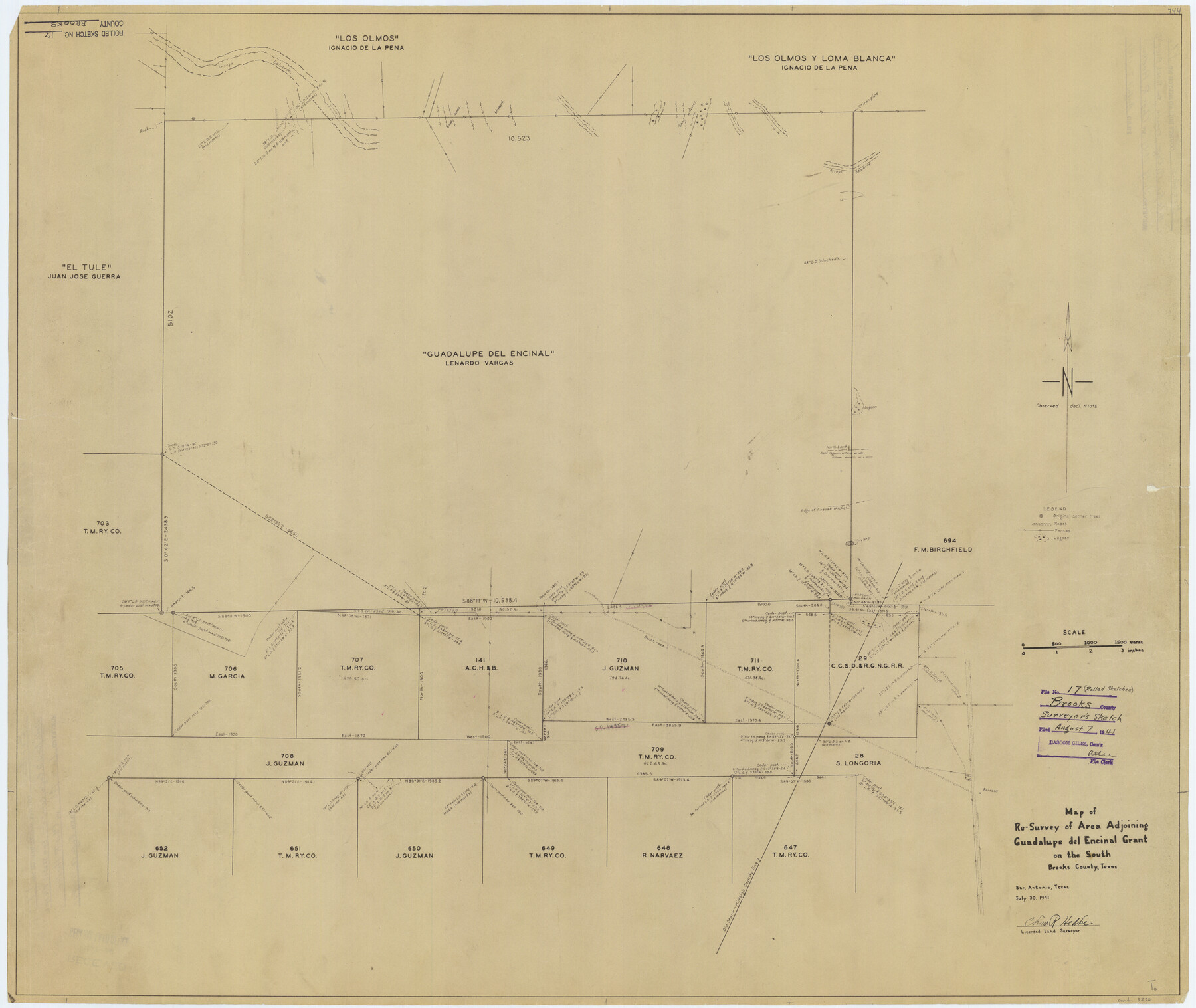
Brooks County Rolled Sketch 17
Map of re-survey of area adjoining Guadalupe del Encinal grant on the south
-
Map/Doc
8532
-
Collection
General Map Collection
-
Object Dates
1941/7/30 (Creation Date)
1941/8/7 (File Date)
-
People and Organizations
Chas. R. Hedke (Surveyor/Engineer)
-
Counties
Brooks
-
Subjects
Surveying Rolled Sketch
-
Height x Width
30.8 x 36.5 inches
78.2 x 92.7 cm
-
Medium
van dyke/brownline/sepia
-
Scale
1" = 500 varas
-
Comments
See Brooks County Sketch File 6 (16560) for surveyor’s report and Brooks County Rolled Sketch 16 (5341) for another related sketch.
Related maps
Brooks County Sketch File 6

Print $12.00
- Digital $50.00
Brooks County Sketch File 6
1941
Size 13.2 x 8.3 inches
Map/Doc 16560
Brooks County Rolled Sketch 16

Print $20.00
- Digital $50.00
Brooks County Rolled Sketch 16
1941
Size 18.0 x 18.8 inches
Map/Doc 5341
Part of: General Map Collection
El Paso County Working Sketch 40

Print $20.00
- Digital $50.00
El Paso County Working Sketch 40
1992
Size 21.5 x 24.0 inches
Map/Doc 69062
La Salle County

Print $20.00
- Digital $50.00
La Salle County
1886
Size 25.4 x 21.3 inches
Map/Doc 3795
Shelby County Working Sketch 7

Print $20.00
- Digital $50.00
Shelby County Working Sketch 7
1942
Size 40.2 x 44.2 inches
Map/Doc 63860
Crane County Rolled Sketch 22

Print $20.00
- Digital $50.00
Crane County Rolled Sketch 22
1990
Size 12.5 x 19.3 inches
Map/Doc 5578
[Maps of surveys in Reeves & Culberson Cos]
![61137, [Maps of surveys in Reeves & Culberson Cos], General Map Collection](https://historictexasmaps.com/wmedia_w700/maps/61137.tif.jpg)
Print $20.00
- Digital $50.00
[Maps of surveys in Reeves & Culberson Cos]
1937
Size 30.5 x 24.8 inches
Map/Doc 61137
Edwards County Working Sketch 112

Print $20.00
- Digital $50.00
Edwards County Working Sketch 112
1972
Size 20.0 x 26.4 inches
Map/Doc 68988
Hydography Survey H-1465 Corpus Christi Pass
Print $20.00
- Digital $50.00
Hydography Survey H-1465 Corpus Christi Pass
1880
Size 45.0 x 40.9 inches
Map/Doc 2695
Brewster County Rolled Sketch 11

Print $20.00
- Digital $50.00
Brewster County Rolled Sketch 11
1881
Size 24.9 x 23.1 inches
Map/Doc 5191
Flight Mission No. BRA-16M, Frame 99, Jefferson County

Print $20.00
- Digital $50.00
Flight Mission No. BRA-16M, Frame 99, Jefferson County
1953
Size 18.5 x 22.4 inches
Map/Doc 85711
Potter County Working Sketch 1

Print $20.00
- Digital $50.00
Potter County Working Sketch 1
Size 16.3 x 17.2 inches
Map/Doc 71661


You may also like
Nolan County Working Sketch 11

Print $40.00
- Digital $50.00
Nolan County Working Sketch 11
1971
Size 67.1 x 37.8 inches
Map/Doc 71302
Map from Corpus Christi to Matagorda Bays, Texas [Inset: Survey of the channel of Copono Bay]
![72974, Map from Corpus Christi to Matagorda Bays, Texas [Inset: Survey of the channel of Copono Bay], General Map Collection](https://historictexasmaps.com/wmedia_w700/maps/72974.tif.jpg)
Print $20.00
- Digital $50.00
Map from Corpus Christi to Matagorda Bays, Texas [Inset: Survey of the channel of Copono Bay]
1846
Size 18.3 x 27.5 inches
Map/Doc 72974
Burleson County Working Sketch 8

Print $20.00
- Digital $50.00
Burleson County Working Sketch 8
1980
Size 29.3 x 23.2 inches
Map/Doc 67727
El Nuevo México y Tierras Adyacentes Levantado para la Demarcación de los Límites de los Dominios Españoles y de los Estados Unidos

El Nuevo México y Tierras Adyacentes Levantado para la Demarcación de los Límites de los Dominios Españoles y de los Estados Unidos
1811
Size 9.4 x 12.6 inches
Map/Doc 94445
Brewster County Rolled Sketch 22B

Print $20.00
- Digital $50.00
Brewster County Rolled Sketch 22B
1910
Size 24.5 x 19.5 inches
Map/Doc 5203
Hidalgo County Rolled Sketch 17

Print $40.00
- Digital $50.00
Hidalgo County Rolled Sketch 17
1963
Size 68.4 x 42.9 inches
Map/Doc 9172
Motley County Boundary File 2b

Print $60.00
- Digital $50.00
Motley County Boundary File 2b
Size 14.3 x 8.8 inches
Map/Doc 57521
Kerr County Sketch File 7

Print $4.00
- Digital $50.00
Kerr County Sketch File 7
1881
Size 8.8 x 15.7 inches
Map/Doc 28869
Val Verde County Rolled Sketch 54

Print $40.00
- Digital $50.00
Val Verde County Rolled Sketch 54
1938
Size 63.5 x 44.0 inches
Map/Doc 8123
Mills County Boundary File 4

Print $40.00
- Digital $50.00
Mills County Boundary File 4
Size 52.1 x 13.3 inches
Map/Doc 57293
El Paso County Rolled Sketch 44

Print $129.00
- Digital $50.00
El Paso County Rolled Sketch 44
1902
Size 10.4 x 15.5 inches
Map/Doc 44430
Leon County Working Sketch 49

Print $20.00
- Digital $50.00
Leon County Working Sketch 49
1981
Size 23.9 x 24.7 inches
Map/Doc 70448