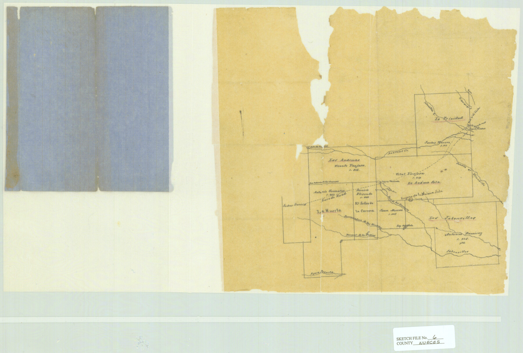
Nueces County Sketch File 6
[Large grants in Jim Wells and Duval Counties]
-
Map/Doc
42175
-
Collection
General Map Collection
-
Counties
Jim Wells Duval
-
Subjects
Surveying Sketch File
-
Height x Width
15.0 x 22.2 inches
38.1 x 56.4 cm
-
Medium
paper, manuscript
-
Features
Saucito Creek
Agua Poquita
Lag[una] del Flato
Jaboncillos [Creek]
Derrano de los Indio
Derramadero de las Urracas
Laguna Mavisala
Derido los Tramajos Creek
Escondida Creek
Reets Creek
Anacuas Creek
Lagoon Trinidad
Laredo Road
Roarke
Road to the Presidio
Jaboncillos Creek
Tiburones Creek
Part of: General Map Collection
Presidio County Working Sketch 114

Print $40.00
- Digital $50.00
Presidio County Working Sketch 114
1981
Size 63.9 x 37.9 inches
Map/Doc 71791
Harris County Rolled Sketch 72

Print $40.00
- Digital $50.00
Harris County Rolled Sketch 72
1945
Size 23.0 x 48.3 inches
Map/Doc 9132
Frio County Rolled Sketch 9

Print $20.00
- Digital $50.00
Frio County Rolled Sketch 9
1943
Size 35.7 x 32.5 inches
Map/Doc 5919
Marion County Rolled Sketch 5

Print $20.00
- Digital $50.00
Marion County Rolled Sketch 5
1961
Size 22.6 x 20.5 inches
Map/Doc 6658
Terrell County Working Sketch 73

Print $20.00
- Digital $50.00
Terrell County Working Sketch 73
1980
Size 29.0 x 47.5 inches
Map/Doc 69594
Victoria County Sketch File 12

Print $4.00
- Digital $50.00
Victoria County Sketch File 12
1978
Size 11.4 x 8.9 inches
Map/Doc 39540
Kinney County Working Sketch 54

Print $20.00
- Digital $50.00
Kinney County Working Sketch 54
1981
Size 40.0 x 32.8 inches
Map/Doc 70236
Red River County Sketch File 5

Print $4.00
- Digital $50.00
Red River County Sketch File 5
Size 7.9 x 4.8 inches
Map/Doc 35102
Sterling County Rolled Sketch 21

Print $20.00
- Digital $50.00
Sterling County Rolled Sketch 21
Size 29.6 x 23.8 inches
Map/Doc 7849
San Patricio County Working Sketch 17

Print $20.00
- Digital $50.00
San Patricio County Working Sketch 17
1953
Size 32.9 x 26.8 inches
Map/Doc 63779
Rockwall County Working Sketch 1

Print $20.00
- Digital $50.00
Rockwall County Working Sketch 1
Size 12.5 x 18.4 inches
Map/Doc 63593
Flight Mission No. BQR-4K, Frame 60, Brazoria County

Print $20.00
- Digital $50.00
Flight Mission No. BQR-4K, Frame 60, Brazoria County
1952
Size 18.7 x 22.4 inches
Map/Doc 83993
You may also like
Upshur County Working Sketch 7

Print $40.00
- Digital $50.00
Upshur County Working Sketch 7
1953
Size 49.0 x 43.1 inches
Map/Doc 69563
Polk County Sketch File 14a

Print $4.00
- Digital $50.00
Polk County Sketch File 14a
1863
Size 9.0 x 14.6 inches
Map/Doc 34155
Flight Mission No. DAG-21K, Frame 118, Matagorda County

Print $20.00
- Digital $50.00
Flight Mission No. DAG-21K, Frame 118, Matagorda County
1952
Size 17.5 x 16.1 inches
Map/Doc 86442
Kimble County Working Sketch 46

Print $20.00
- Digital $50.00
Kimble County Working Sketch 46
1951
Size 29.3 x 18.9 inches
Map/Doc 70114
Fort Bend County

Print $20.00
- Digital $50.00
Fort Bend County
1865
Size 18.2 x 21.8 inches
Map/Doc 3550
Hemphill County Sketch File 9

Print $26.00
- Digital $50.00
Hemphill County Sketch File 9
1955
Size 11.0 x 8.8 inches
Map/Doc 26312
[Jesse Folk and Surrounding Surveys]
![91087, [Jesse Folk and Surrounding Surveys], Twichell Survey Records](https://historictexasmaps.com/wmedia_w700/maps/91087-1.tif.jpg)
Print $20.00
- Digital $50.00
[Jesse Folk and Surrounding Surveys]
1922
Size 21.8 x 33.7 inches
Map/Doc 91087
Montague County Working Sketch 6

Print $20.00
- Digital $50.00
Montague County Working Sketch 6
1923
Size 16.9 x 27.2 inches
Map/Doc 71072
Orange County Working Sketch 50

Print $20.00
- Digital $50.00
Orange County Working Sketch 50
1991
Size 36.0 x 43.6 inches
Map/Doc 71382
Baylor County Sketch File A5

Print $6.00
- Digital $50.00
Baylor County Sketch File A5
Size 10.4 x 8.8 inches
Map/Doc 14088
[Capitol League Sketch in Bailey & Lamb Counties, Texas]
![1764, [Capitol League Sketch in Bailey & Lamb Counties, Texas], General Map Collection](https://historictexasmaps.com/wmedia_w700/maps/1764.tif.jpg)
Print $20.00
- Digital $50.00
[Capitol League Sketch in Bailey & Lamb Counties, Texas]
1910
Size 19.7 x 28.0 inches
Map/Doc 1764
Current Miscellaneous File 101

Print $46.00
- Digital $50.00
Current Miscellaneous File 101
1931
Size 8.8 x 14.2 inches
Map/Doc 74357