Victoria County Sketch File 12
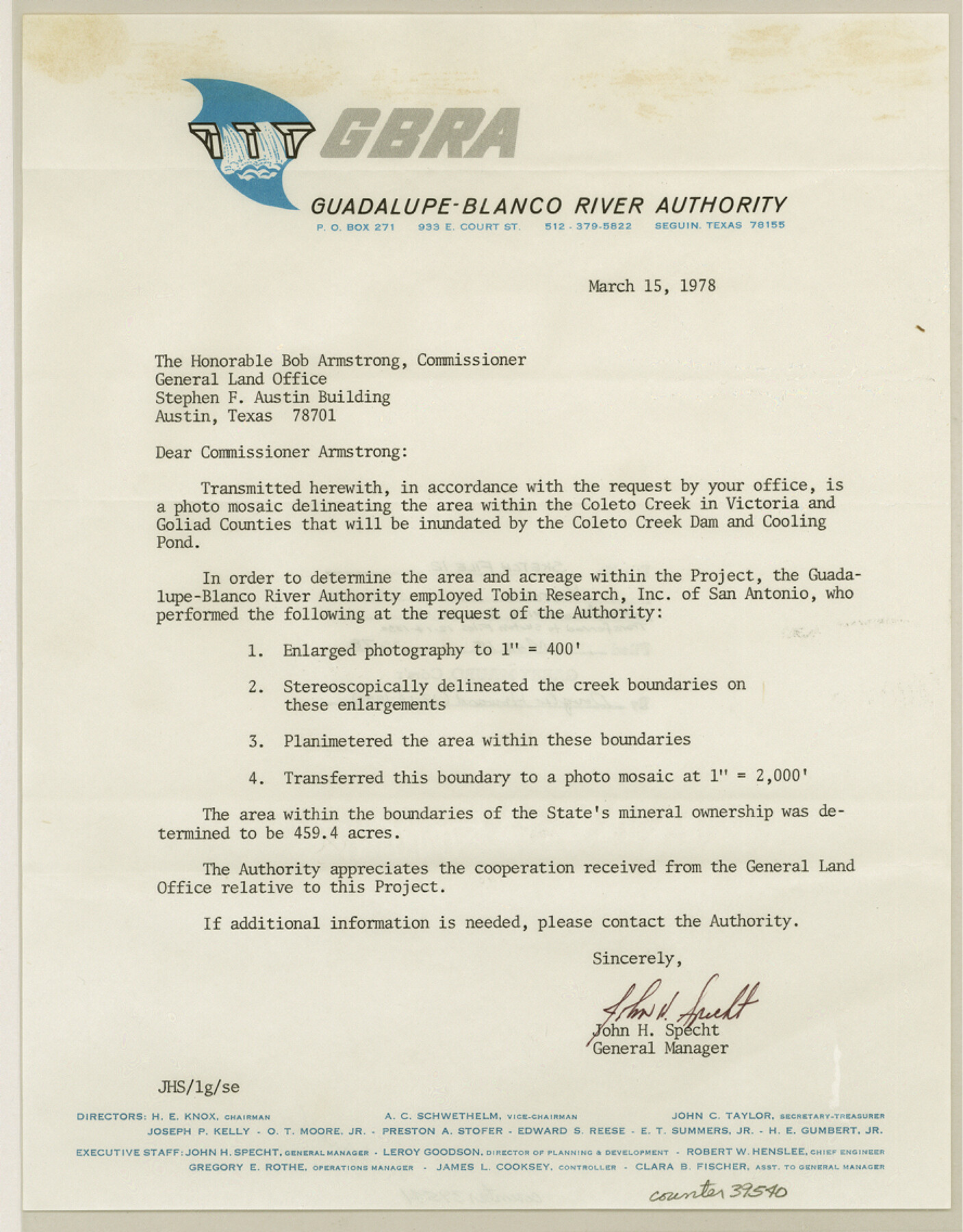
[Letter that accompanied a photo mosaic delineating the area within the Coleto Creek in Victoria and Goliad Counties that will be inundated by the Coleto Creek Dam and Cooling Pond]
-
Map/Doc
39540
-
Collection
General Map Collection
-
Object Dates
3/15/1878 (Creation Date)
-
Counties
Victoria Goliad
-
Subjects
Surveying Sketch File
-
Height x Width
11.4 x 8.9 inches
29.0 x 22.6 cm
-
Medium
paper, print
-
Comments
See Victoria County Rolled Sketch 6 (8152) for aerial photograph.
-
Features
Coleto Creek Dam & Cooling Pond
Coleto Creek
Related maps
Victoria County Rolled Sketch 6

Print $20.00
- Digital $50.00
Victoria County Rolled Sketch 6
Size 27.9 x 36.3 inches
Map/Doc 8152
Part of: General Map Collection
Wilbarger County Sketch File 21

Print $4.00
- Digital $50.00
Wilbarger County Sketch File 21
1889
Size 11.1 x 8.6 inches
Map/Doc 40219
Flight Mission No. BRE-2P, Frame 132, Nueces County

Print $20.00
- Digital $50.00
Flight Mission No. BRE-2P, Frame 132, Nueces County
1956
Size 18.4 x 22.5 inches
Map/Doc 86805
Panola County Sketch File 20

Print $22.00
- Digital $50.00
Panola County Sketch File 20
Size 8.3 x 14.6 inches
Map/Doc 33485
Map of Nacogdoches County

Print $20.00
- Digital $50.00
Map of Nacogdoches County
1881
Size 24.1 x 21.2 inches
Map/Doc 4603
Haskell County Boundary File 4a

Print $62.00
- Digital $50.00
Haskell County Boundary File 4a
Size 9.0 x 4.5 inches
Map/Doc 54545
Maverick County Rolled Sketch 16

Print $20.00
- Digital $50.00
Maverick County Rolled Sketch 16
1887
Size 21.5 x 31.9 inches
Map/Doc 6709
Refugio County Sketch File 8a

Print $2.00
- Digital $50.00
Refugio County Sketch File 8a
Size 8.1 x 10.2 inches
Map/Doc 35253
Kendall County Sketch File 13

Print $4.00
- Digital $50.00
Kendall County Sketch File 13
1860
Size 10.1 x 8.0 inches
Map/Doc 28699
Moore County Sketch File X

Print $20.00
- Digital $50.00
Moore County Sketch File X
Size 34.3 x 24.6 inches
Map/Doc 42131
Polk County Sketch File 40

Print $4.00
- Digital $50.00
Polk County Sketch File 40
Size 10.9 x 8.5 inches
Map/Doc 34290
Flight Mission No. DAH-17M, Frame 65, Orange County

Print $20.00
- Digital $50.00
Flight Mission No. DAH-17M, Frame 65, Orange County
1953
Size 18.8 x 22.5 inches
Map/Doc 86899
Terry County Working Sketch 3

Print $40.00
- Digital $50.00
Terry County Working Sketch 3
1953
Size 125.9 x 28.4 inches
Map/Doc 62108
You may also like
Flight Mission No. DQN-5K, Frame 24, Calhoun County

Print $20.00
- Digital $50.00
Flight Mission No. DQN-5K, Frame 24, Calhoun County
1953
Size 18.5 x 22.1 inches
Map/Doc 84375
Dickens County Sketch File N

Print $4.00
- Digital $50.00
Dickens County Sketch File N
1903
Size 8.3 x 13.6 inches
Map/Doc 20942
Sketch of Bull Pasture

Print $3.00
- Digital $50.00
Sketch of Bull Pasture
Size 9.3 x 12.1 inches
Map/Doc 91450
Stephens County Sketch File 27

Print $6.00
- Digital $50.00
Stephens County Sketch File 27
Size 9.7 x 8.5 inches
Map/Doc 37101
Clay County Boundary File 17

Print $8.00
- Digital $50.00
Clay County Boundary File 17
Size 13.8 x 8.4 inches
Map/Doc 51432
Nueces County NRC Article 33.136 Location Key Sheet

Print $20.00
- Digital $50.00
Nueces County NRC Article 33.136 Location Key Sheet
1975
Size 27.0 x 22.8 inches
Map/Doc 77033
Frio County Rolled Sketch 18

Print $20.00
- Digital $50.00
Frio County Rolled Sketch 18
1955
Size 41.2 x 43.4 inches
Map/Doc 8908
Map of Lamar County

Print $20.00
- Digital $50.00
Map of Lamar County
1849
Size 25.7 x 26.8 inches
Map/Doc 1236
Brewster County Sketch File B-1

Print $6.00
- Digital $50.00
Brewster County Sketch File B-1
1910
Size 14.2 x 8.8 inches
Map/Doc 15716
General Highway Map, Collingsworth County, Texas

Print $20.00
General Highway Map, Collingsworth County, Texas
1940
Size 18.3 x 25.2 inches
Map/Doc 79053
Baylor County Boundary File 13

Print $44.00
- Digital $50.00
Baylor County Boundary File 13
Size 4.3 x 9.7 inches
Map/Doc 50424
Stonewall County Rolled Sketch 25

Print $20.00
- Digital $50.00
Stonewall County Rolled Sketch 25
1952
Size 27.8 x 22.1 inches
Map/Doc 7873