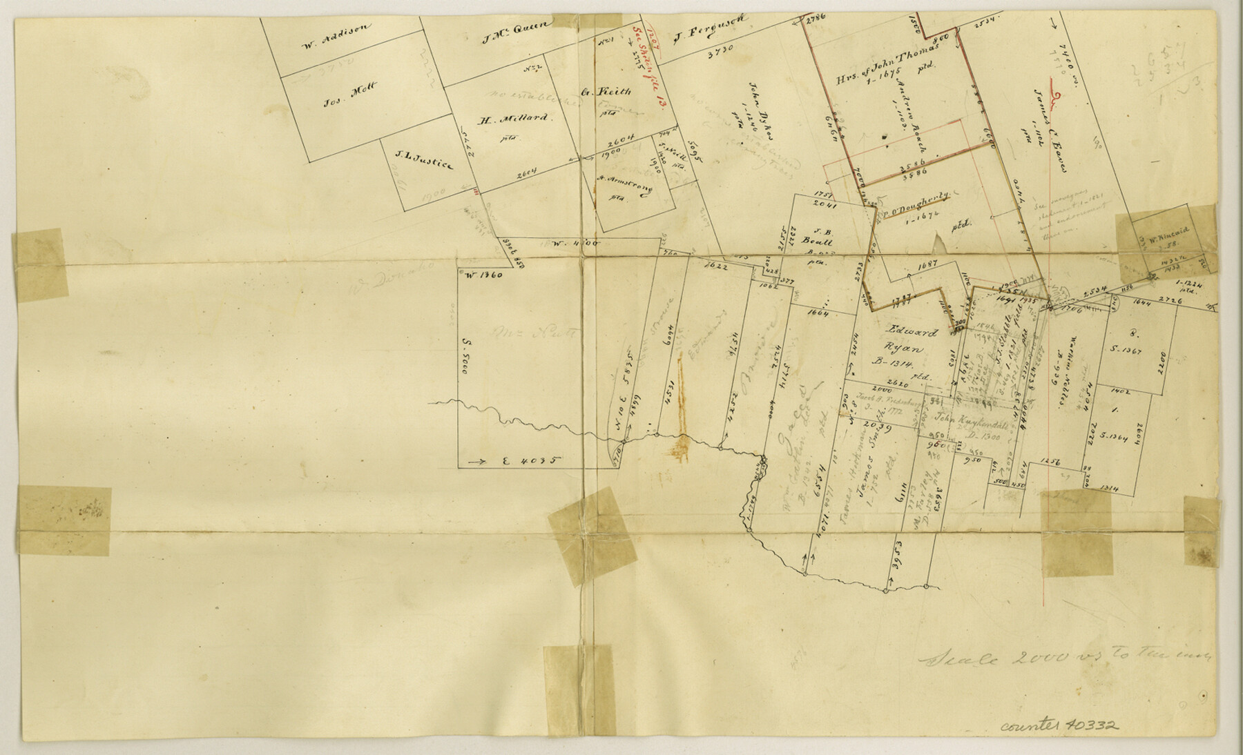
Williamson County Sketch File 14
[Office sketch of area around the Edward Ryan survey southeast from Georgetown]
-
Map/Doc
40332
-
Collection
General Map Collection
-
Object Dates
3/31/1871 (Creation Date)
-
People and Organizations
Thielepape (Surveyor/Engineer)
-
Counties
Williamson
-
Subjects
Surveying Sketch File
-
Height x Width
9.4 x 15.4 inches
23.9 x 39.1 cm
-
Medium
paper, manuscript
-
Scale
1" = 2000 varas
Part of: General Map Collection
Real County Working Sketch 73

Print $20.00
- Digital $50.00
Real County Working Sketch 73
1978
Size 28.2 x 24.9 inches
Map/Doc 71965
Bexar County Sketch File 27

Print $4.00
- Digital $50.00
Bexar County Sketch File 27
1860
Size 8.6 x 6.5 inches
Map/Doc 14490
Jeff Davis County Rolled Sketch 20

Print $20.00
- Digital $50.00
Jeff Davis County Rolled Sketch 20
1944
Size 22.7 x 19.6 inches
Map/Doc 7724
Midland County Working Sketch 17

Print $40.00
- Digital $50.00
Midland County Working Sketch 17
1953
Size 32.3 x 49.4 inches
Map/Doc 70997
Boundary Between the United States & Mexico Agreed upon by the Joint Commission under the Treaty of Guadalupe Hidalgo

Print $4.00
- Digital $50.00
Boundary Between the United States & Mexico Agreed upon by the Joint Commission under the Treaty of Guadalupe Hidalgo
1853
Size 18.3 x 26.8 inches
Map/Doc 72881

Flight Mission No. DAG-17K, Frame 139, Matagorda County

Print $20.00
- Digital $50.00
Flight Mission No. DAG-17K, Frame 139, Matagorda County
1952
Size 18.5 x 22.3 inches
Map/Doc 86356
Brewster County Rolled Sketch 60

Print $40.00
- Digital $50.00
Brewster County Rolled Sketch 60
Size 36.7 x 50.8 inches
Map/Doc 9200
Topographic Map, Reynard Sheet, Trinity River; Houston and Leon Counties

Print $20.00
- Digital $50.00
Topographic Map, Reynard Sheet, Trinity River; Houston and Leon Counties
1925
Size 45.6 x 41.4 inches
Map/Doc 2469
Harris County Sketch File 32a

Print $4.00
- Digital $50.00
Harris County Sketch File 32a
1895
Size 14.1 x 9.0 inches
Map/Doc 25436

Leon County Working Sketch 45

Print $20.00
- Digital $50.00
Leon County Working Sketch 45
1980
Size 45.4 x 37.4 inches
Map/Doc 70444
You may also like
[Northeast Portion of Kaufman County]
![91028, [Northeast Portion of Kaufman County], Twichell Survey Records](https://historictexasmaps.com/wmedia_w700/maps/91028-1.tif.jpg)
Print $20.00
- Digital $50.00
[Northeast Portion of Kaufman County]
Size 40.1 x 37.0 inches
Map/Doc 91028
Hutchinson County Sketch File 50

Print $12.00
- Digital $50.00
Hutchinson County Sketch File 50
1992
Size 14.2 x 8.8 inches
Map/Doc 27434
Polk County Working Sketch 34

Print $20.00
- Digital $50.00
Polk County Working Sketch 34
1961
Size 41.3 x 42.0 inches
Map/Doc 71651
Flight Mission No. DQO-1K, Frame 115, Galveston County

Print $20.00
- Digital $50.00
Flight Mission No. DQO-1K, Frame 115, Galveston County
1952
Size 18.9 x 22.5 inches
Map/Doc 84993
Fractional Township No. 10 South Range No. 26 East of the Indian Meridian, Indian Territory

Print $20.00
- Digital $50.00
Fractional Township No. 10 South Range No. 26 East of the Indian Meridian, Indian Territory
1897
Size 19.2 x 24.3 inches
Map/Doc 75245

Hale County Sketch File 14

Print $8.00
- Digital $50.00
Hale County Sketch File 14
Size 14.1 x 8.7 inches
Map/Doc 24743
Cooke County Working Sketch 3

Print $20.00
- Digital $50.00
Cooke County Working Sketch 3
1926
Size 27.5 x 39.9 inches
Map/Doc 68240
Briscoe County Sketch File 3

Print $40.00
- Digital $50.00
Briscoe County Sketch File 3
1885
Size 22.6 x 20.7 inches
Map/Doc 10992
Jefferson County Working Sketch 39

Print $20.00
- Digital $50.00
Jefferson County Working Sketch 39
1984
Size 39.3 x 28.2 inches
Map/Doc 66583
Flight Mission No. DCL-6C, Frame 28, Kenedy County

Print $20.00
- Digital $50.00
Flight Mission No. DCL-6C, Frame 28, Kenedy County
1943
Size 18.7 x 22.4 inches
Map/Doc 85885
Throckmorton County

Print $20.00
- Digital $50.00
Throckmorton County
1885
Size 24.9 x 18.7 inches
Map/Doc 4080