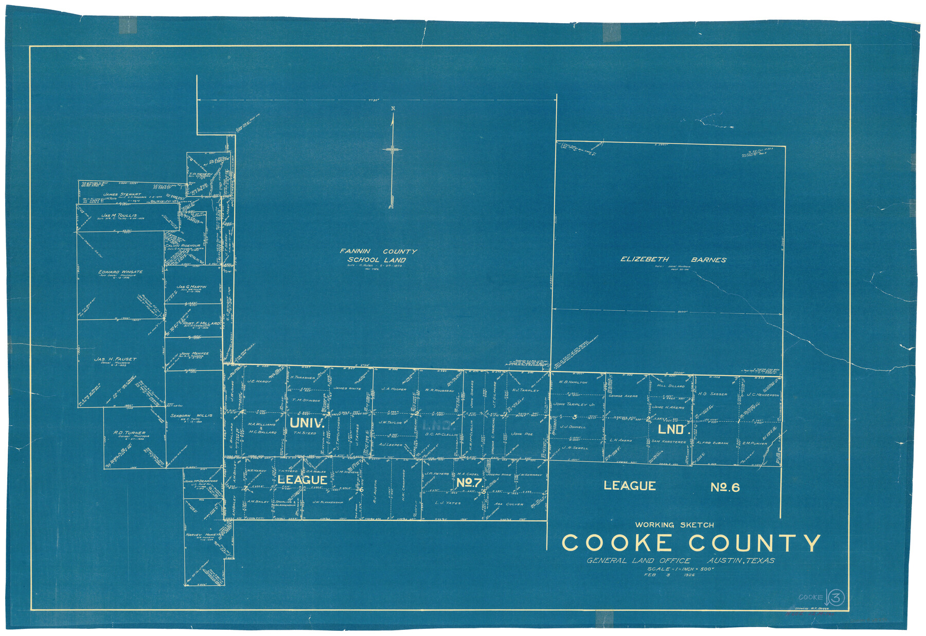
Cooke County Working Sketch 3
-
Map/Doc
68240
-
Collection
General Map Collection
-
Object Dates
2/3/1926 (Creation Date)
-
People and Organizations
W.K. Boggs (Draftsman)
-
Counties
Cooke
-
Subjects
Surveying Working Sketch
-
Height x Width
27.5 x 39.9 inches
69.9 x 101.4 cm
-
Scale
1" = 500 varas
Part of: General Map Collection
DeWitt County Sketch File 7

Print $2.00
- Digital $50.00
DeWitt County Sketch File 7
1876
Size 11.3 x 9.0 inches
Map/Doc 20817
Maverick County Sketch File 3

Print $40.00
- Digital $50.00
Maverick County Sketch File 3
Size 18.3 x 11.6 inches
Map/Doc 31033
Trinity River, South Dallas Sheet

Print $20.00
- Digital $50.00
Trinity River, South Dallas Sheet
1917
Size 28.8 x 21.4 inches
Map/Doc 69684
Blanco County Sketch File 12

Print $20.00
- Digital $50.00
Blanco County Sketch File 12
Size 15.0 x 19.8 inches
Map/Doc 10928
Colonists' and Emigrants' Route to Texas

Print $20.00
- Digital $50.00
Colonists' and Emigrants' Route to Texas
1878
Size 14.8 x 24.0 inches
Map/Doc 94033
[Cotton Belt] St. Louis Southwestern Railway of Texas, Alignment through Smith County
![64373, [Cotton Belt] St. Louis Southwestern Railway of Texas, Alignment through Smith County, General Map Collection](https://historictexasmaps.com/wmedia_w700/maps/64373.tif.jpg)
Print $20.00
- Digital $50.00
[Cotton Belt] St. Louis Southwestern Railway of Texas, Alignment through Smith County
1903
Size 21.4 x 28.4 inches
Map/Doc 64373
Medina County Working Sketch 19

Print $20.00
- Digital $50.00
Medina County Working Sketch 19
1980
Size 19.4 x 29.1 inches
Map/Doc 70934
Martin County Working Sketch 9

Print $20.00
- Digital $50.00
Martin County Working Sketch 9
1971
Size 45.2 x 38.1 inches
Map/Doc 70827
Pecos County Rolled Sketch 47

Print $20.00
- Digital $50.00
Pecos County Rolled Sketch 47
1913
Size 20.3 x 43.8 inches
Map/Doc 7225
Sketch No. 2 Showing Land Ties with Houston & Texas Central Rail Road through Harris County, Texas

Print $20.00
- Digital $50.00
Sketch No. 2 Showing Land Ties with Houston & Texas Central Rail Road through Harris County, Texas
1880
Size 8.5 x 26.9 inches
Map/Doc 64496
Real County Rolled Sketch 8

Print $20.00
- Digital $50.00
Real County Rolled Sketch 8
1967
Size 32.0 x 36.7 inches
Map/Doc 9833
Hudspeth County Rolled Sketch 57

Print $20.00
- Digital $50.00
Hudspeth County Rolled Sketch 57
Size 38.3 x 46.0 inches
Map/Doc 9223
You may also like
Day Ranch Lands, Leaday, Texas

Print $20.00
- Digital $50.00
Day Ranch Lands, Leaday, Texas
1948
Size 30.8 x 23.0 inches
Map/Doc 81516
Mitchell County Working Sketch 5

Print $40.00
- Digital $50.00
Mitchell County Working Sketch 5
1956
Size 60.4 x 28.2 inches
Map/Doc 71062
Map of San Antonio Bay and Vicinity in Aransas and Calhoun Counties showing subdivision for mineral development

Print $40.00
- Digital $50.00
Map of San Antonio Bay and Vicinity in Aransas and Calhoun Counties showing subdivision for mineral development
1939
Size 40.4 x 62.8 inches
Map/Doc 2925
Southern Part of Laguna Madre

Print $20.00
- Digital $50.00
Southern Part of Laguna Madre
1949
Size 33.8 x 26.7 inches
Map/Doc 73536
Matagorda County Rolled Sketch 29

Print $20.00
- Digital $50.00
Matagorda County Rolled Sketch 29
1936
Size 36.6 x 27.2 inches
Map/Doc 6691
Culberson County Rolled Sketch 9

Print $20.00
- Digital $50.00
Culberson County Rolled Sketch 9
1886
Size 28.3 x 41.9 inches
Map/Doc 5646
Township No. 5 South Range No. 11 West of the Indian Meridian

Print $20.00
- Digital $50.00
Township No. 5 South Range No. 11 West of the Indian Meridian
1875
Size 19.3 x 24.3 inches
Map/Doc 75160
[3KA and vicinity]
![90847, [3KA and vicinity], Twichell Survey Records](https://historictexasmaps.com/wmedia_w700/maps/90847-2.tif.jpg)
Print $20.00
- Digital $50.00
[3KA and vicinity]
Size 31.3 x 15.4 inches
Map/Doc 90847
R. S. Dod Meanders

Print $20.00
- Digital $50.00
R. S. Dod Meanders
Size 19.0 x 13.2 inches
Map/Doc 91675
Tarrant County Working Sketch 26

Print $20.00
- Digital $50.00
Tarrant County Working Sketch 26
2004
Size 27.1 x 43.9 inches
Map/Doc 83586
Coleman County Sketch File 35

Print $2.00
- Digital $50.00
Coleman County Sketch File 35
Size 8.4 x 8.2 inches
Map/Doc 18740
Shackelford County Working Sketch 9

Print $20.00
- Digital $50.00
Shackelford County Working Sketch 9
1974
Size 30.1 x 22.2 inches
Map/Doc 63849