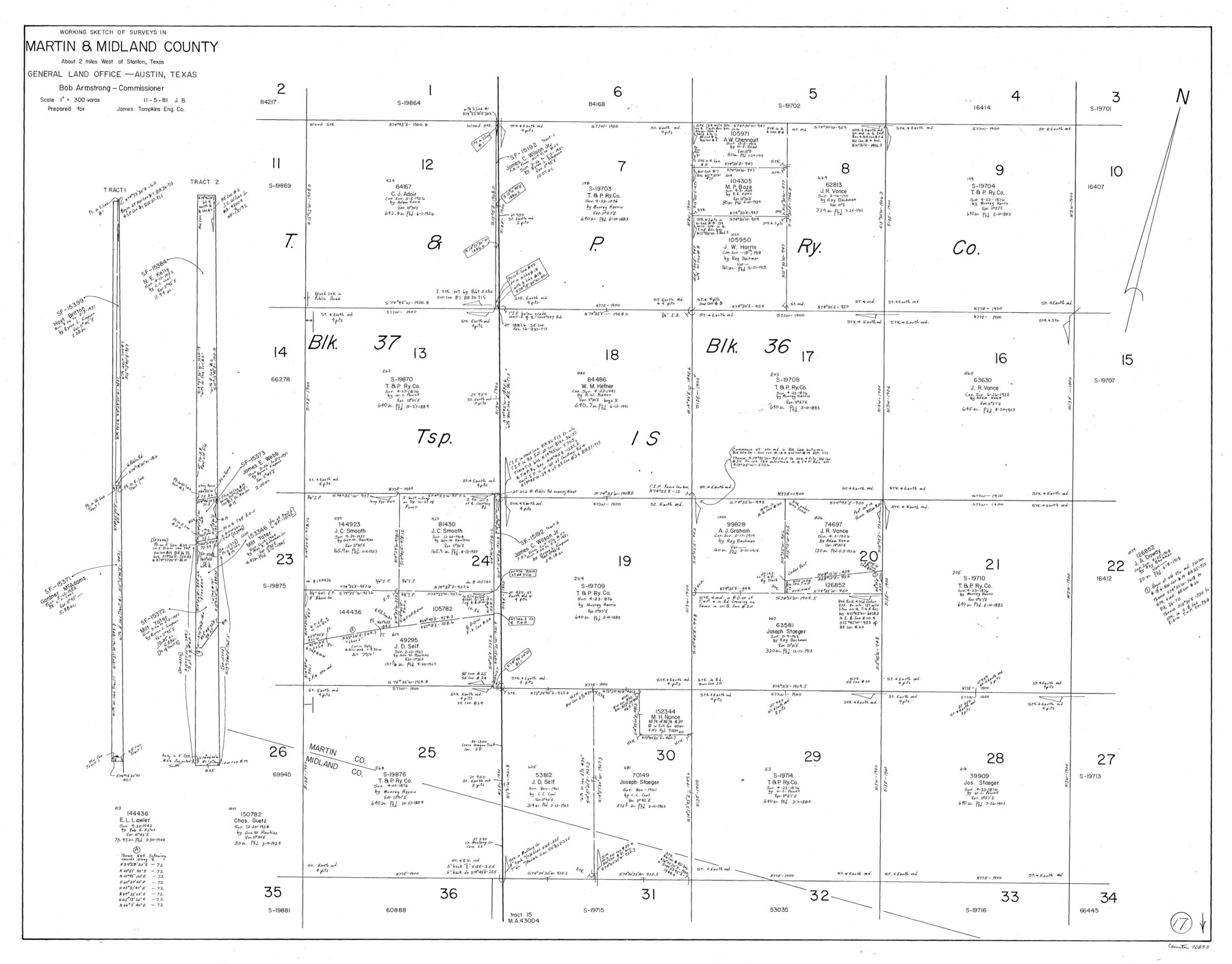
Martin County Working Sketch 17
-
Map/Doc
70835
-
Collection
General Map Collection
-
Object Dates
11/5/1981 (Creation Date)
-
People and Organizations
Jana Brod (Draftsman)
-
Counties
Martin Midland
-
Subjects
Surveying Working Sketch
-
Height x Width
32.4 x 41.4 inches
82.3 x 105.2 cm
-
Scale
1" = 300 varas
Part of: General Map Collection
Tyler County Working Sketch 20

Print $20.00
- Digital $50.00
Tyler County Working Sketch 20
1982
Size 41.0 x 32.7 inches
Map/Doc 69490
Liberty County Sketch File 27a

Print $4.00
- Digital $50.00
Liberty County Sketch File 27a
1870
Size 11.6 x 9.0 inches
Map/Doc 29950
Jefferson County Sketch File 24

Print $6.00
- Digital $50.00
Jefferson County Sketch File 24
Size 10.8 x 6.8 inches
Map/Doc 28181
Flight Mission No. CRC-4R, Frame 72, Chambers County

Print $20.00
- Digital $50.00
Flight Mission No. CRC-4R, Frame 72, Chambers County
1956
Size 18.8 x 22.4 inches
Map/Doc 84876
Grayson County Sketch File 19

Print $7.00
- Digital $50.00
Grayson County Sketch File 19
1860
Size 12.1 x 7.7 inches
Map/Doc 24490
Val Verde County Rolled Sketch 64

Print $20.00
- Digital $50.00
Val Verde County Rolled Sketch 64
1937
Size 24.6 x 18.2 inches
Map/Doc 8129
Presidio County Rolled Sketch 134

Print $20.00
- Digital $50.00
Presidio County Rolled Sketch 134
Size 26.6 x 39.6 inches
Map/Doc 7401
Johnson's New Military Map of the United States Showing the Forts, Military Posts & c. with Enlarged Plans of Southern Harbors

Print $20.00
- Digital $50.00
Johnson's New Military Map of the United States Showing the Forts, Military Posts & c. with Enlarged Plans of Southern Harbors
1863
Size 17.7 x 23.3 inches
Map/Doc 93289

Crane County Working Sketch 19

Print $20.00
- Digital $50.00
Crane County Working Sketch 19
1958
Size 28.6 x 38.8 inches
Map/Doc 68296
Tom Green County Rolled Sketch 17

Print $40.00
- Digital $50.00
Tom Green County Rolled Sketch 17
Size 49.2 x 37.8 inches
Map/Doc 10005
[Portion of Panola Judicial District]
![78365, [Portion of Panola Judicial District], General Map Collection](https://historictexasmaps.com/wmedia_w700/maps/78365.tif.jpg)
Print $3.00
- Digital $50.00
[Portion of Panola Judicial District]
1841
Size 17.1 x 10.0 inches
Map/Doc 78365
You may also like
Polk County Working Sketch 18

Print $20.00
- Digital $50.00
Polk County Working Sketch 18
1949
Size 25.4 x 23.3 inches
Map/Doc 71633
Dickens County Rolled Sketch 13

Print $40.00
- Digital $50.00
Dickens County Rolled Sketch 13
1950
Size 44.3 x 53.8 inches
Map/Doc 44296
Subdivision Map of Fisher County School Land situated in Bailey and Cochran Counties, Texas

Print $20.00
- Digital $50.00
Subdivision Map of Fisher County School Land situated in Bailey and Cochran Counties, Texas
1924
Size 17.3 x 21.3 inches
Map/Doc 90111
Flight Mission No. DCL-6C, Frame 48, Kenedy County

Print $20.00
- Digital $50.00
Flight Mission No. DCL-6C, Frame 48, Kenedy County
1943
Size 18.7 x 22.3 inches
Map/Doc 85890
Real County Working Sketch 48

Print $20.00
- Digital $50.00
Real County Working Sketch 48
1956
Size 29.4 x 18.5 inches
Map/Doc 71940
Washington County Sketch File 2

Print $4.00
- Digital $50.00
Washington County Sketch File 2
1855
Size 8.3 x 12.5 inches
Map/Doc 39646
Map showing portion of 140 acre tract owned by Schriener Institute near Kerrville, Texas

Print $40.00
- Digital $50.00
Map showing portion of 140 acre tract owned by Schriener Institute near Kerrville, Texas
1922
Size 31.6 x 53.0 inches
Map/Doc 89443
[Worksheets related to the Wilson Strickland survey and vicinity]
![91384, [Worksheets related to the Wilson Strickland survey and vicinity], Twichell Survey Records](https://historictexasmaps.com/wmedia_w700/maps/91384-1.tif.jpg)
Print $20.00
- Digital $50.00
[Worksheets related to the Wilson Strickland survey and vicinity]
Size 23.6 x 28.0 inches
Map/Doc 91384
Ward County Working Sketch 36

Print $40.00
- Digital $50.00
Ward County Working Sketch 36
1969
Size 49.8 x 48.9 inches
Map/Doc 72342
The Land Offices. No. 10, Bexar, December 22, 1836

Print $20.00
The Land Offices. No. 10, Bexar, December 22, 1836
2020
Size 19.2 x 16.2 inches
Map/Doc 96423
General Highway Map, Fayette County, Texas

Print $20.00
General Highway Map, Fayette County, Texas
1961
Size 18.2 x 24.5 inches
Map/Doc 79465
Galveston County Rolled Sketch CCW

Print $20.00
- Digital $50.00
Galveston County Rolled Sketch CCW
1938
Size 38.4 x 39.7 inches
Map/Doc 9084