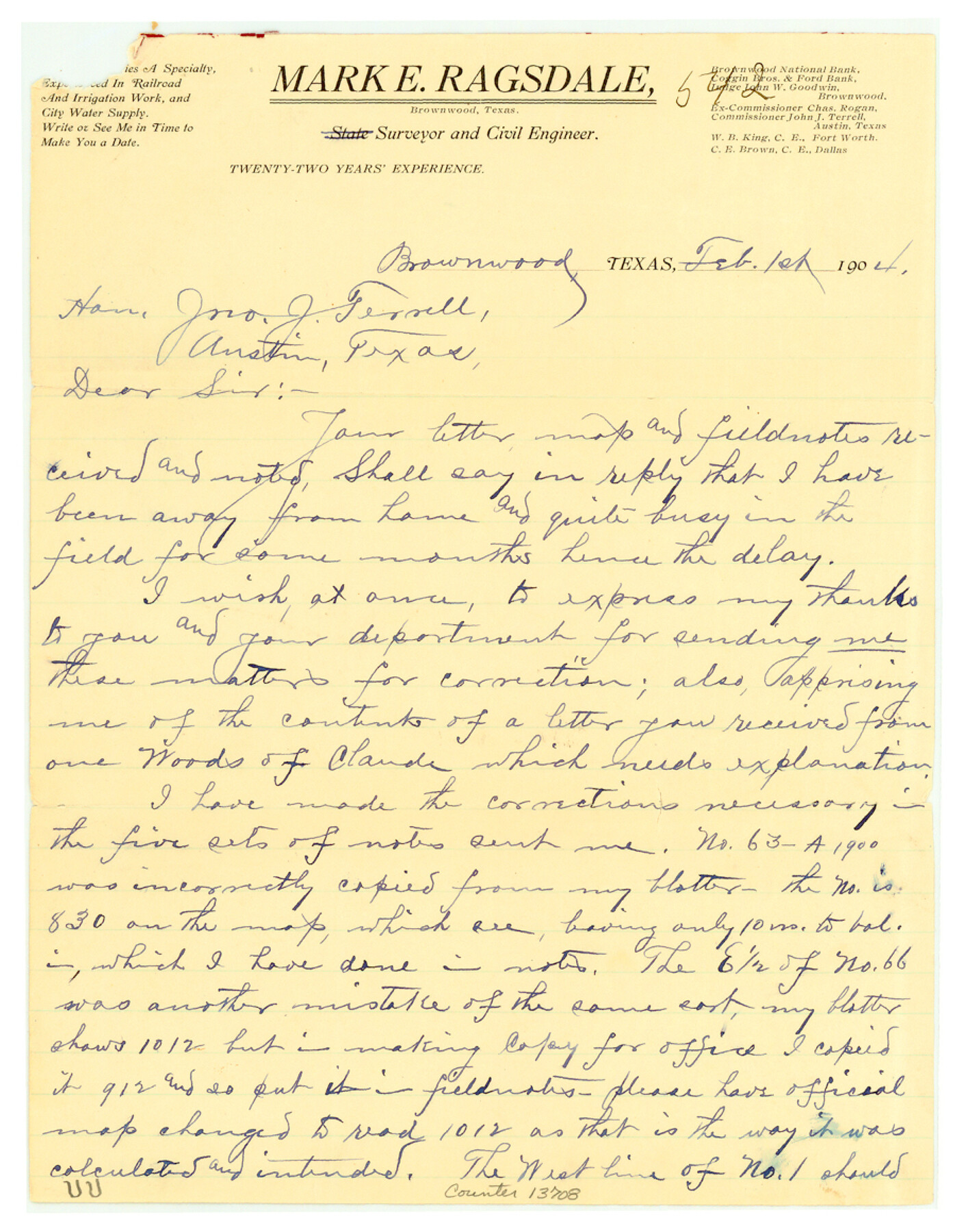
Armstrong County Sketch File 9
[Letter regarding certificate and comments on certain surveys in Blocks A1900 and 4Z]
-
Map/Doc
41460
-
Collection
General Map Collection
-
Object Dates
1904/2/1 (Creation Date)
-
People and Organizations
Mark E. Ragsdale (Surveyor/Engineer)
-
Counties
Armstrong
-
Subjects
Surveying Sketch File
-
Height x Width
11.6 x 9.1 inches
29.5 x 23.1 cm
-
Medium
paper, manuscript
-
Features
Red River
Dry Creek
Part of: General Map Collection
Galveston County NRC Article 33.136 Sketch 51

Print $20.00
- Digital $50.00
Galveston County NRC Article 33.136 Sketch 51
Size 24.0 x 36.0 inches
Map/Doc 93785
Flight Mission No. CLL-11AA, Frame 172, Willacy County

Print $20.00
- Digital $50.00
Flight Mission No. CLL-11AA, Frame 172, Willacy County
1962
Size 18.4 x 18.2 inches
Map/Doc 87091
Brazoria County Sketch File 7

Print $4.00
- Digital $50.00
Brazoria County Sketch File 7
1868
Size 8.6 x 11.0 inches
Map/Doc 14932
Hockley County Sketch File 13

Print $4.00
- Digital $50.00
Hockley County Sketch File 13
1914
Size 8.9 x 10.9 inches
Map/Doc 26548
Newton County Rolled Sketch 6

Print $20.00
- Digital $50.00
Newton County Rolled Sketch 6
Size 24.9 x 45.7 inches
Map/Doc 6842
Blanco County Rolled Sketch 11

Print $6.00
- Digital $50.00
Blanco County Rolled Sketch 11
Size 33.2 x 27.8 inches
Map/Doc 5147
El Paso County Working Sketch 21

Print $20.00
- Digital $50.00
El Paso County Working Sketch 21
1960
Size 37.8 x 30.9 inches
Map/Doc 69043
Map of Hill County

Print $40.00
- Digital $50.00
Map of Hill County
1884
Size 80.0 x 35.2 inches
Map/Doc 93379
Anderson County Working Sketch 11

Print $40.00
- Digital $50.00
Anderson County Working Sketch 11
1933
Size 42.8 x 57.9 inches
Map/Doc 67010
San Patricio County Sketch File 45

Print $20.00
- Digital $50.00
San Patricio County Sketch File 45
1943
Size 11.2 x 8.9 inches
Map/Doc 36273
Hudspeth County Working Sketch 38

Print $20.00
- Digital $50.00
Hudspeth County Working Sketch 38
1978
Size 31.8 x 36.9 inches
Map/Doc 66323
Terrell County Sketch File 15

Print $20.00
- Digital $50.00
Terrell County Sketch File 15
1890
Size 16.0 x 21.6 inches
Map/Doc 12421
You may also like
Jefferson County Rolled Sketch 12

Print $2.00
- Digital $50.00
Jefferson County Rolled Sketch 12
Size 12.2 x 7.1 inches
Map/Doc 9279
[Beaumont, Sour Lake and Western Ry. Right of Way and Alignment - Frisco]
![64133, [Beaumont, Sour Lake and Western Ry. Right of Way and Alignment - Frisco], General Map Collection](https://historictexasmaps.com/wmedia_w700/maps/64133.tif.jpg)
Print $20.00
- Digital $50.00
[Beaumont, Sour Lake and Western Ry. Right of Way and Alignment - Frisco]
1910
Size 20.0 x 45.5 inches
Map/Doc 64133
Panola County Working Sketch 11

Print $20.00
- Digital $50.00
Panola County Working Sketch 11
1944
Map/Doc 71420
Map of the World on a Globular Projection to illustrate Olney's school geography

Print $20.00
- Digital $50.00
Map of the World on a Globular Projection to illustrate Olney's school geography
1844
Size 12.1 x 19.0 inches
Map/Doc 93535
Flight Mission No. CUG-1P, Frame 77, Kleberg County

Print $20.00
- Digital $50.00
Flight Mission No. CUG-1P, Frame 77, Kleberg County
1956
Size 18.4 x 22.1 inches
Map/Doc 86142
Record of Spanish Titles, Vol. I

Record of Spanish Titles, Vol. I
1845
Size 19.2 x 13.9 inches
Map/Doc 94526
Hardeman County Sketch File Y

Print $4.00
- Digital $50.00
Hardeman County Sketch File Y
Size 9.2 x 8.5 inches
Map/Doc 25054
Fort Bend County State Real Property Sketch 9

Print $40.00
- Digital $50.00
Fort Bend County State Real Property Sketch 9
1986
Size 34.7 x 43.2 inches
Map/Doc 61683
[Sketch showing H. & T. C. Block 47]
![91699, [Sketch showing H. & T. C. Block 47], Twichell Survey Records](https://historictexasmaps.com/wmedia_w700/maps/91699-1.tif.jpg)
Print $2.00
- Digital $50.00
[Sketch showing H. & T. C. Block 47]
Size 6.1 x 6.7 inches
Map/Doc 91699
Kerr County Sketch File 25

Print $4.00
- Digital $50.00
Kerr County Sketch File 25
1873
Size 10.0 x 8.0 inches
Map/Doc 28905
Briscoe County

Print $20.00
- Digital $50.00
Briscoe County
1930
Size 46.2 x 39.2 inches
Map/Doc 1787
Flight Mission No. BRA-8M, Frame 121, Jefferson County

Print $20.00
- Digital $50.00
Flight Mission No. BRA-8M, Frame 121, Jefferson County
1953
Size 18.5 x 22.4 inches
Map/Doc 85617