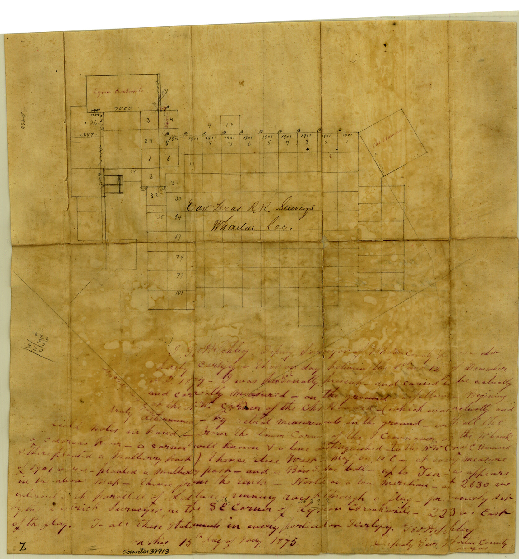
Wharton County Sketch File 2
[Sketch of East Texas R.R. Co. surveys and surrounding area southwest from Wharton]
-
Map/Doc
39913
-
Collection
General Map Collection
-
Object Dates
7/15/1875 (Creation Date)
3/1/1875 (File Date)
-
People and Organizations
George H. Schley (Surveyor/Engineer)
-
Counties
Wharton
-
Subjects
Surveying Sketch File
-
Height x Width
13.6 x 12.6 inches
34.5 x 32.0 cm
-
Medium
paper, manuscript
Part of: General Map Collection
Nautical Chart 152-SC - Galveston Bay, Texas

Print $20.00
- Digital $50.00
Nautical Chart 152-SC - Galveston Bay, Texas
1972
Size 15.1 x 32.6 inches
Map/Doc 69892
Wise County Working Sketch 21

Print $20.00
- Digital $50.00
Wise County Working Sketch 21
1980
Size 25.9 x 32.4 inches
Map/Doc 72635
Grayson County Working Sketch 6

Print $20.00
- Digital $50.00
Grayson County Working Sketch 6
1940
Size 28.6 x 40.5 inches
Map/Doc 63245

Anderson County Rolled Sketch 10

Print $20.00
- Digital $50.00
Anderson County Rolled Sketch 10
1956
Size 33.4 x 34.6 inches
Map/Doc 8365
Wilson County Boundary File 3

Print $26.00
- Digital $50.00
Wilson County Boundary File 3
Size 14.3 x 8.7 inches
Map/Doc 60083
Potter County

Print $20.00
- Digital $50.00
Potter County
1960
Size 40.0 x 32.3 inches
Map/Doc 77397
Sutton County Working Sketch 4

Print $20.00
- Digital $50.00
Sutton County Working Sketch 4
1969
Size 40.3 x 32.2 inches
Map/Doc 62347
Lampasas County Working Sketch 11

Print $20.00
- Digital $50.00
Lampasas County Working Sketch 11
1964
Size 38.3 x 42.8 inches
Map/Doc 70288
Jackson County Sketch File 24

Print $20.00
- Digital $50.00
Jackson County Sketch File 24
1949
Size 17.5 x 23.4 inches
Map/Doc 11844
Oldham County Sketch File 4

Print $20.00
- Digital $50.00
Oldham County Sketch File 4
1883
Size 13.7 x 22.5 inches
Map/Doc 12111
Webb County Sketch File 11-2

Print $6.00
- Digital $50.00
Webb County Sketch File 11-2
1932
Size 9.9 x 4.5 inches
Map/Doc 39788
You may also like
Falls County Sketch File 15

Print $4.00
- Digital $50.00
Falls County Sketch File 15
Size 13.0 x 8.2 inches
Map/Doc 22372
[Surveys in Austin's Colony near La Bahia Road]
![200, [Surveys in Austin's Colony near La Bahia Road], General Map Collection](https://historictexasmaps.com/wmedia_w700/maps/200.tif.jpg)
Print $20.00
- Digital $50.00
[Surveys in Austin's Colony near La Bahia Road]
1821
Size 10.4 x 20.2 inches
Map/Doc 200
Flight Mission No. DIX-8P, Frame 94, Aransas County

Print $20.00
- Digital $50.00
Flight Mission No. DIX-8P, Frame 94, Aransas County
1956
Size 18.5 x 22.3 inches
Map/Doc 83919
Camp County Working Sketch 1

Print $20.00
- Digital $50.00
Camp County Working Sketch 1
1970
Size 32.9 x 29.7 inches
Map/Doc 67877
Map Showing Location and Right of Way of Proposed Groins - to be built by U.S. Government Along Seawall at Galveston, Texas

Print $20.00
- Digital $50.00
Map Showing Location and Right of Way of Proposed Groins - to be built by U.S. Government Along Seawall at Galveston, Texas
1935
Size 20.8 x 36.3 inches
Map/Doc 73622
Childress County Working Sketch 5

Print $20.00
- Digital $50.00
Childress County Working Sketch 5
1948
Size 19.6 x 23.5 inches
Map/Doc 68021
Real County Rolled Sketch JCA

Print $20.00
- Digital $50.00
Real County Rolled Sketch JCA
Size 27.9 x 36.5 inches
Map/Doc 7470
Reagan County Sketch File 9

Print $20.00
- Digital $50.00
Reagan County Sketch File 9
1928
Size 27.0 x 22.3 inches
Map/Doc 12216
Bandera County Working Sketch 44

Print $20.00
- Digital $50.00
Bandera County Working Sketch 44
1980
Size 14.0 x 20.4 inches
Map/Doc 67640
Bailey County Sketch File 11a

Print $4.00
- Digital $50.00
Bailey County Sketch File 11a
1912
Size 8.4 x 11.1 inches
Map/Doc 13967
Garza County Sketch

Print $20.00
- Digital $50.00
Garza County Sketch
1924
Size 19.6 x 18.4 inches
Map/Doc 92701
Navigation Maps of Gulf Intracoastal Waterway, Port Arthur to Brownsville, Texas

Print $4.00
- Digital $50.00
Navigation Maps of Gulf Intracoastal Waterway, Port Arthur to Brownsville, Texas
1951
Size 16.8 x 21.6 inches
Map/Doc 65419