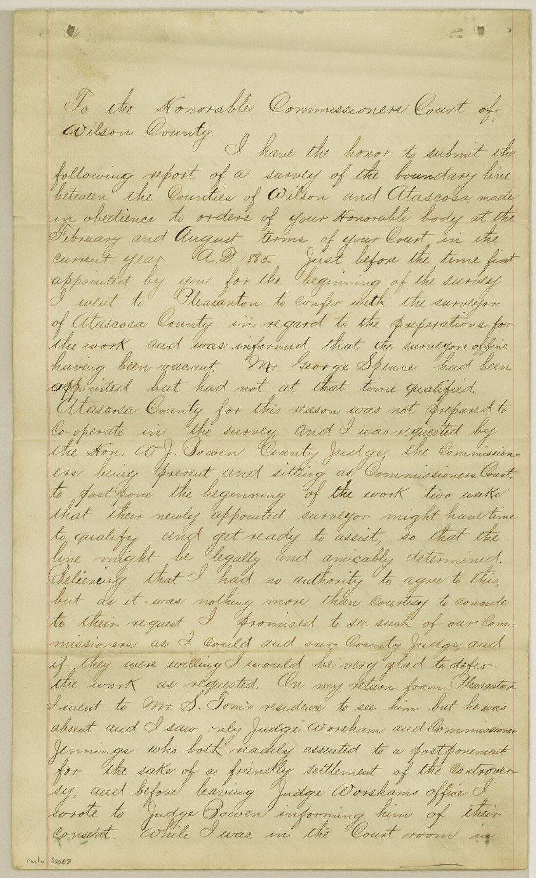
Wilson County Boundary File 3
Certified Copy of Report of W. T. Sutherland Co. surveyor Wilson & Atascosa Counties
-
Map/Doc
60083
-
Collection
General Map Collection
-
Counties
Wilson
-
Subjects
County Boundaries
-
Height x Width
14.3 x 8.7 inches
36.3 x 22.1 cm
Part of: General Map Collection
Webb County Sketch File 14

Print $7.00
- Digital $50.00
Webb County Sketch File 14
1877
Size 10.0 x 8.2 inches
Map/Doc 39807
Map of [Coleman County]
![3413, Map of [Coleman County], General Map Collection](https://historictexasmaps.com/wmedia_w700/maps/3413-1.tif.jpg)
Print $20.00
- Digital $50.00
Map of [Coleman County]
1878
Size 24.9 x 21.9 inches
Map/Doc 3413
Upton County Working Sketch 41

Print $40.00
- Digital $50.00
Upton County Working Sketch 41
1960
Size 40.4 x 54.2 inches
Map/Doc 69537
Maps of Gulf Intracoastal Waterway, Texas - Sabine River to the Rio Grande and connecting waterways including ship channels

Print $20.00
- Digital $50.00
Maps of Gulf Intracoastal Waterway, Texas - Sabine River to the Rio Grande and connecting waterways including ship channels
1966
Size 14.5 x 22.2 inches
Map/Doc 61974
Shelby County Rolled Sketch 6

Print $20.00
- Digital $50.00
Shelby County Rolled Sketch 6
Size 26.7 x 20.9 inches
Map/Doc 7776
Newton County Working Sketch 36

Print $20.00
- Digital $50.00
Newton County Working Sketch 36
1960
Size 29.9 x 39.1 inches
Map/Doc 71282
Sterling County

Print $20.00
- Digital $50.00
Sterling County
1891
Size 23.2 x 17.7 inches
Map/Doc 4056
Map of the 1st, 2nd and 3rd Sections of Houston & Texas Central Railroad

Print $40.00
- Digital $50.00
Map of the 1st, 2nd and 3rd Sections of Houston & Texas Central Railroad
Size 30.7 x 64.6 inches
Map/Doc 64478
Concho County Sketch File X

Print $20.00
- Digital $50.00
Concho County Sketch File X
1916
Size 39.4 x 23.7 inches
Map/Doc 11168
Flight Mission No. CRK-3P, Frame 61, Refugio County

Print $20.00
- Digital $50.00
Flight Mission No. CRK-3P, Frame 61, Refugio County
1956
Size 18.7 x 22.5 inches
Map/Doc 86903
Presidio County Sketch File 106

Print $60.00
- Digital $50.00
Presidio County Sketch File 106
1983
Size 25.3 x 38.3 inches
Map/Doc 10580
Lee County Working Sketch 10

Print $20.00
- Digital $50.00
Lee County Working Sketch 10
1979
Size 32.6 x 35.4 inches
Map/Doc 70389
You may also like
Tom Green County Sketch File 13

Print $4.00
- Digital $50.00
Tom Green County Sketch File 13
Size 6.3 x 8.4 inches
Map/Doc 38170
Flight Mission No. DCL-7C, Frame 143, Kenedy County

Print $20.00
- Digital $50.00
Flight Mission No. DCL-7C, Frame 143, Kenedy County
1943
Size 18.6 x 22.3 inches
Map/Doc 86100
Fannin County

Print $20.00
- Digital $50.00
Fannin County
1946
Size 40.6 x 35.4 inches
Map/Doc 77277
Travis County Working Sketch 49

Print $20.00
- Digital $50.00
Travis County Working Sketch 49
1984
Size 33.9 x 37.2 inches
Map/Doc 69433
Crane County Working Sketch 32

Print $20.00
- Digital $50.00
Crane County Working Sketch 32
1984
Size 37.6 x 43.1 inches
Map/Doc 68309
Jasper County Rolled Sketch 9

Print $83.00
- Digital $50.00
Jasper County Rolled Sketch 9
1932
Size 10.7 x 15.4 inches
Map/Doc 46171
Palo Pinto County Sketch File 23

Print $20.00
- Digital $50.00
Palo Pinto County Sketch File 23
1949
Size 23.5 x 15.4 inches
Map/Doc 12135
Flight Mission No. BRE-1P, Frame 34, Nueces County

Print $20.00
- Digital $50.00
Flight Mission No. BRE-1P, Frame 34, Nueces County
1956
Size 18.4 x 22.2 inches
Map/Doc 86630
Clay County Sketch File 16

Print $9.00
- Digital $50.00
Clay County Sketch File 16
1874
Size 8.3 x 7.9 inches
Map/Doc 18421
Austin County Boundary File 3

Print $2.00
- Digital $50.00
Austin County Boundary File 3
Size 14.3 x 8.6 inches
Map/Doc 50243
Montgomery County Rolled Sketch 13A

Print $20.00
- Digital $50.00
Montgomery County Rolled Sketch 13A
1932
Size 17.7 x 27.5 inches
Map/Doc 6802
