Falls County Sketch File 15
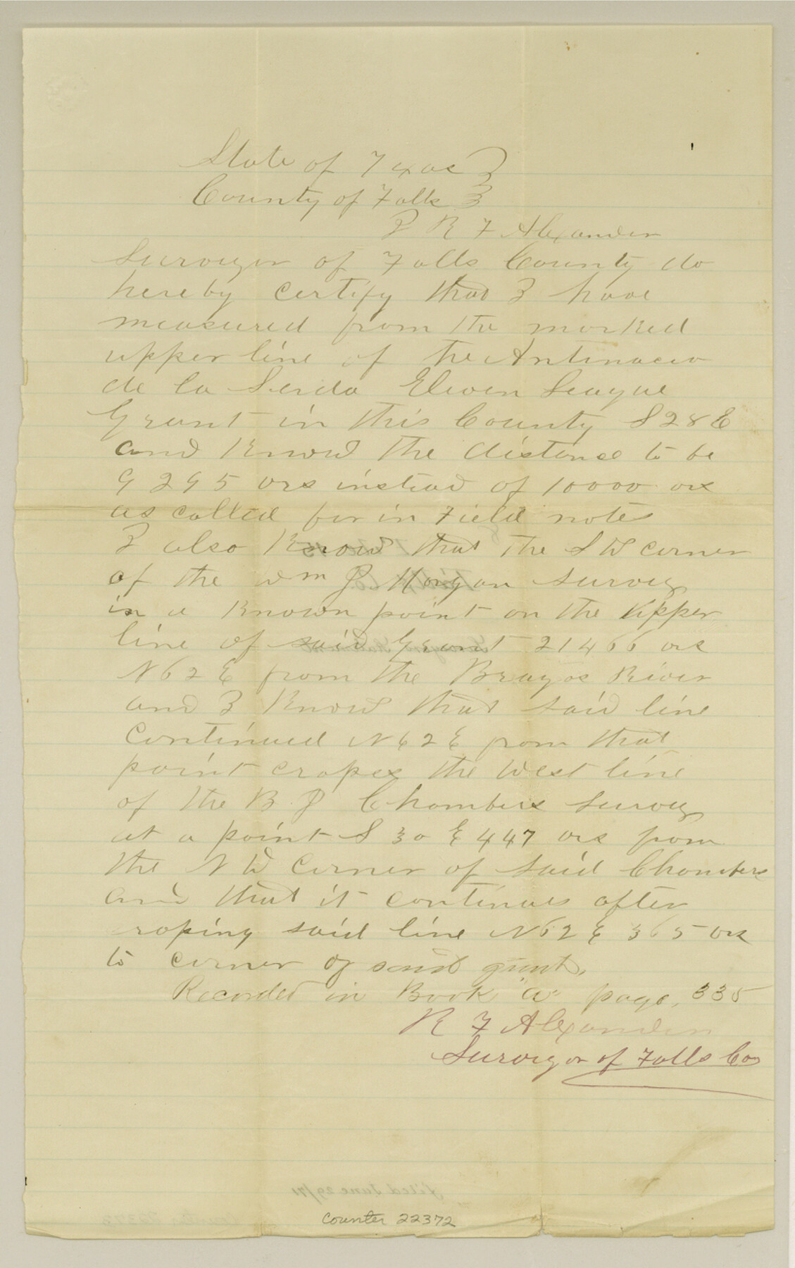
[Surveyor's statement regarding Antenacio de la Serda 11 league grant]
-
Map/Doc
22372
-
Collection
General Map Collection
-
Object Dates
1871/6/29 (File Date)
-
People and Organizations
R.F. Alexander (Surveyor/Engineer)
-
Counties
Falls
-
Subjects
Surveying Sketch File
-
Height x Width
13.0 x 8.2 inches
33.0 x 20.8 cm
-
Medium
paper, manuscript
Part of: General Map Collection

Red River County Sketch File 25

Print $20.00
- Digital $50.00
Red River County Sketch File 25
Size 26.0 x 38.9 inches
Map/Doc 10586
Map of Nacogdoches County

Print $20.00
- Digital $50.00
Map of Nacogdoches County
1881
Size 25.2 x 20.7 inches
Map/Doc 4601
Brewster County Rolled Sketch 134

Print $20.00
- Digital $50.00
Brewster County Rolled Sketch 134
Size 19.0 x 24.9 inches
Map/Doc 5303
Angelina County Sketch File 6

Print $4.00
- Digital $50.00
Angelina County Sketch File 6
1856
Size 8.1 x 8.2 inches
Map/Doc 12933
Runnels County Working Sketch 27
Print $20.00
- Digital $50.00
Runnels County Working Sketch 27
1957
Size 27.1 x 22.1 inches
Map/Doc 63623
Polk County Working Sketch 30

Print $20.00
- Digital $50.00
Polk County Working Sketch 30
1960
Size 18.2 x 24.4 inches
Map/Doc 71646

Webb County Sketch File 48

Print $20.00
- Digital $50.00
Webb County Sketch File 48
1939
Size 17.9 x 26.7 inches
Map/Doc 12646

Terrell County Working Sketch 65

Print $40.00
- Digital $50.00
Terrell County Working Sketch 65
1972
Size 49.0 x 44.8 inches
Map/Doc 69586
Flight Mission No. DCL-7C, Frame 12, Kenedy County

Print $20.00
- Digital $50.00
Flight Mission No. DCL-7C, Frame 12, Kenedy County
1943
Size 15.4 x 15.3 inches
Map/Doc 86004
You may also like
[Leagues 7, 8, 9, and 10]
![92216, [Leagues 7, 8, 9, and 10], Twichell Survey Records](https://historictexasmaps.com/wmedia_w700/maps/92216-1.tif.jpg)
Print $20.00
- Digital $50.00
[Leagues 7, 8, 9, and 10]
Size 38.3 x 26.2 inches
Map/Doc 92216
Callahan County Sketch File 6

Print $42.00
- Digital $50.00
Callahan County Sketch File 6
1858
Size 8.2 x 6.4 inches
Map/Doc 35859
Commemorative Map of the Republic of Texas, 1845

Print $27.06
Commemorative Map of the Republic of Texas, 1845
1986
Size 32.7 x 26.7 inches
Map/Doc 89023
Map of Goliad County Texas

Print $20.00
- Digital $50.00
Map of Goliad County Texas
1879
Size 19.2 x 21.3 inches
Map/Doc 4547
Cottle County Rolled Sketch 15

Print $20.00
- Digital $50.00
Cottle County Rolled Sketch 15
2004
Size 37.2 x 37.2 inches
Map/Doc 82849
Midland County Working Sketch 5

Print $20.00
- Digital $50.00
Midland County Working Sketch 5
1893
Size 31.2 x 25.6 inches
Map/Doc 70985
Galveston County NRC Article 33.136 Sketch 19

Print $50.00
- Digital $50.00
Galveston County NRC Article 33.136 Sketch 19
2002
Size 37.1 x 25.4 inches
Map/Doc 78491
Nueces County NRC Article 33.136 Sketch 3

Print $68.00
- Digital $50.00
Nueces County NRC Article 33.136 Sketch 3
2002
Size 24.7 x 36.5 inches
Map/Doc 87922
Harris County Working Sketch 69

Print $20.00
- Digital $50.00
Harris County Working Sketch 69
1956
Size 32.7 x 28.2 inches
Map/Doc 65961
Briscoe County Rolled Sketch 6

Print $20.00
- Digital $50.00
Briscoe County Rolled Sketch 6
Size 27.0 x 31.4 inches
Map/Doc 5326
Flight Mission No. DIX-10P, Frame 167, Aransas County

Print $20.00
- Digital $50.00
Flight Mission No. DIX-10P, Frame 167, Aransas County
1956
Size 18.6 x 22.3 inches
Map/Doc 83957
Val Verde County Working Sketch 76

Print $20.00
- Digital $50.00
Val Verde County Working Sketch 76
1971
Size 38.4 x 37.4 inches
Map/Doc 72211