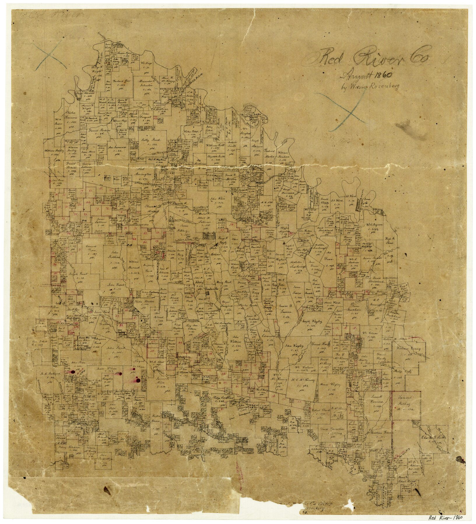
Red River County
-
Map/Doc
3980
-
Collection
General Map Collection
-
Object Dates
8/1860 (Creation Date)
-
People and Organizations
Texas General Land Office (Publisher)
W. von Rosenberg (Compiler)
W. von Rosenberg (Draftsman)
-
Counties
Red River
-
Subjects
County
-
Height x Width
23.0 x 20.8 inches
58.4 x 52.8 cm
-
Features
Elm Creek
Wild Cat Creek
Pecan Bayou
Boggy Creek
Kicapoo [sic] Creek
Whiteoak [sic] Creek
Anderson Creek
Young's Creek
South Fork of Cuthand Creek
Mustang Creek
Brushy Creek
Little Mustang Creek
South Fork of White Oak Creek
Brutons Creek
Big Caney Creek
Walnut Branch [of Blythe's Creek]
Blythe's Creek
Boothes Creek
Shawnee Lake
Culp's Ferry
Sulpher Fork [of Red River]
Burkham's Creek
Little Whiteoak [sic] Creek
Little May's Bayou
Clear Creek
Guest's Creek
Hamilton's Bayou
Haslett's Lake
Pine Creek
Little Pine Creek
Burris's Bend
Slingland Lake
Atkinsons Lake
North Fork of Pecan Bayou
Basons Mill Creek
Daton Road
White Oak Fork of Pecan Bayou
Ward's Creek
Kiamichi
South Fork of Pecan Bayou
Caney Creek
Little Creek
Mill Creek
Beaverdam Creek
Meander Creek
Jack's Creek
Gruggs Creek
Clarksville
Langford's Creek
Telavaro Fork
Part of: General Map Collection
Upshur County Rolled Sketch 6

Print $20.00
- Digital $50.00
Upshur County Rolled Sketch 6
2003
Size 37.0 x 25.1 inches
Map/Doc 81941
Nueces County Rolled Sketch 35

Print $20.00
- Digital $50.00
Nueces County Rolled Sketch 35
1910
Size 33.6 x 24.3 inches
Map/Doc 6877
Archer County Working Sketch 17

Print $3.00
- Digital $50.00
Archer County Working Sketch 17
1951
Size 10.7 x 12.2 inches
Map/Doc 67158
St. Louis, Brownsville & Mexico Railway Location Map from Mile 40 to Mile 60

Print $40.00
- Digital $50.00
St. Louis, Brownsville & Mexico Railway Location Map from Mile 40 to Mile 60
1905
Size 20.3 x 136.1 inches
Map/Doc 89282
Hood County Sketch File 9

Print $26.00
- Digital $50.00
Hood County Sketch File 9
1859
Size 9.6 x 4.5 inches
Map/Doc 26586
Chambers County Rolled Sketch 26

Print $20.00
- Digital $50.00
Chambers County Rolled Sketch 26
1947
Size 12.7 x 19.9 inches
Map/Doc 5428
Right of Way & Track Map Houston & Brazos Valley Ry. operated by Houston & Brazos Valley Ry. Co., Hoskins Mound Branch

Print $40.00
- Digital $50.00
Right of Way & Track Map Houston & Brazos Valley Ry. operated by Houston & Brazos Valley Ry. Co., Hoskins Mound Branch
1924
Size 25.3 x 56.4 inches
Map/Doc 64609
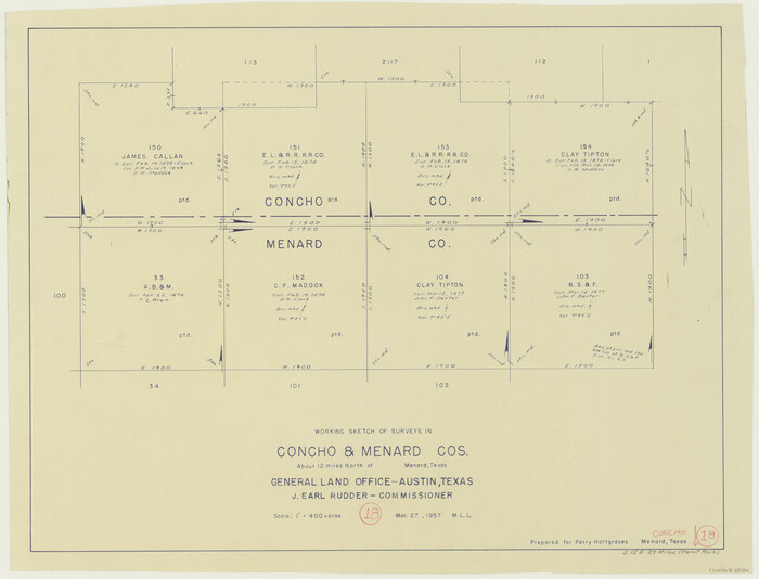
Concho County Working Sketch 18
Print $20.00
- Digital $50.00
Concho County Working Sketch 18
1957
Size 19.2 x 25.2 inches
Map/Doc 68200
Rusk County Rolled Sketch 10

Print $18.00
- Digital $50.00
Rusk County Rolled Sketch 10
Size 9.7 x 11.3 inches
Map/Doc 48864
Gray County Boundary File 7

Print $4.00
- Digital $50.00
Gray County Boundary File 7
Size 8.0 x 8.8 inches
Map/Doc 53898
Liberty County

Print $20.00
- Digital $50.00
Liberty County
1862
Size 24.3 x 24.8 inches
Map/Doc 3815
Ochiltree County Boundary File 8

Print $8.00
- Digital $50.00
Ochiltree County Boundary File 8
Size 11.2 x 8.7 inches
Map/Doc 57716
You may also like
Angelina County Working Sketch 15

Print $20.00
- Digital $50.00
Angelina County Working Sketch 15
1935
Size 34.0 x 38.4 inches
Map/Doc 67096
Map of Harrison County

Print $20.00
- Digital $50.00
Map of Harrison County
1911
Size 43.8 x 39.8 inches
Map/Doc 4698
McMullen County Working Sketch 56

Print $20.00
- Digital $50.00
McMullen County Working Sketch 56
1983
Size 23.9 x 24.1 inches
Map/Doc 70757
South Umbarger in Randall County, Texas

Print $20.00
- Digital $50.00
South Umbarger in Randall County, Texas
1905
Size 31.2 x 30.7 inches
Map/Doc 92153
Flight Mission No. DCL-5C, Frame 68, Kenedy County

Print $20.00
- Digital $50.00
Flight Mission No. DCL-5C, Frame 68, Kenedy County
1943
Size 18.6 x 22.4 inches
Map/Doc 85851
Marion County Sketch File 10

Print $4.00
- Digital $50.00
Marion County Sketch File 10
1867
Size 7.9 x 12.4 inches
Map/Doc 30579
Medina County Rolled Sketch 12

Print $20.00
- Digital $50.00
Medina County Rolled Sketch 12
1979
Size 20.9 x 14.7 inches
Map/Doc 6746
Wood County Boundary File 2a

Print $6.00
- Digital $50.00
Wood County Boundary File 2a
Size 10.0 x 8.0 inches
Map/Doc 60159
Cooke County Working Sketch 29
Print $20.00
- Digital $50.00
Cooke County Working Sketch 29
1977
Size 28.7 x 35.0 inches
Map/Doc 68266
Liberty County Sketch File 29

Print $40.00
- Digital $50.00
Liberty County Sketch File 29
1888
Size 14.9 x 14.9 inches
Map/Doc 29955
Flight Mission No. CGI-3N, Frame 74, Cameron County

Print $20.00
- Digital $50.00
Flight Mission No. CGI-3N, Frame 74, Cameron County
1954
Size 18.7 x 22.2 inches
Map/Doc 84568
Bowie County Working Sketch 22

Print $40.00
- Digital $50.00
Bowie County Working Sketch 22
1968
Size 49.0 x 37.8 inches
Map/Doc 67426