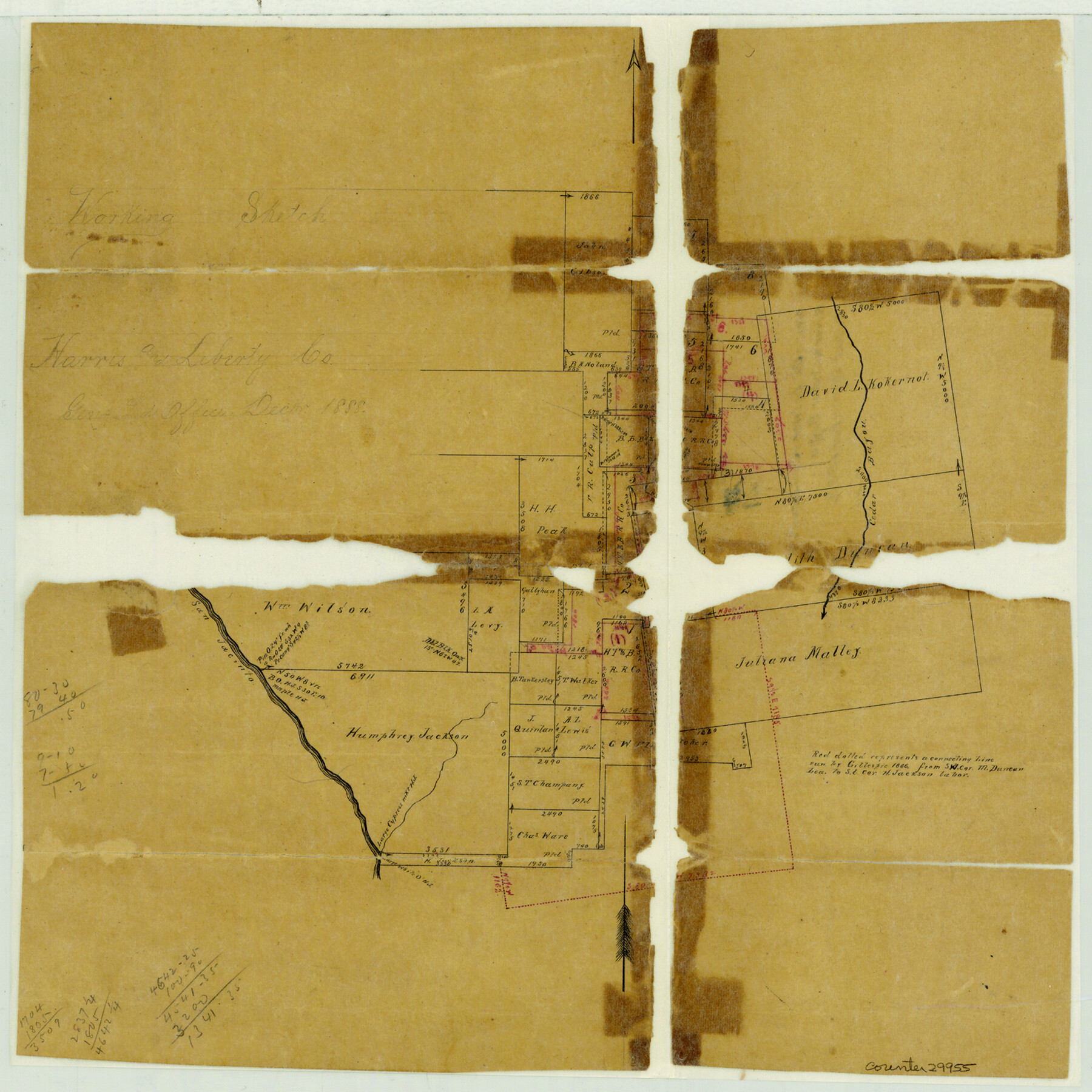
Liberty County Sketch File 29
[Office sketch of area between San Jacinto River and Cedar Bayou in Harris and Liberty Counties]
-
Map/Doc
29955
-
Collection
General Map Collection
-
Object Dates
12/1888 (Creation Date)
-
Counties
Liberty Harris
-
Subjects
Surveying Sketch File
-
Height x Width
14.9 x 14.9 inches
37.9 x 37.9 cm
-
Medium
paper, manuscript
Part of: General Map Collection
Eastland County Working Sketch 21

Print $20.00
- Digital $50.00
Eastland County Working Sketch 21
1920
Size 15.4 x 22.7 inches
Map/Doc 68802
Reeves County Rolled Sketch P

Print $20.00
- Digital $50.00
Reeves County Rolled Sketch P
Size 33.2 x 29.2 inches
Map/Doc 9847
Improving Sabine Pass, Texas. Surveyed May 10th to June 30th, 1894 under the direction of Major James B. Quinn, Corps of Engineers, USA

Print $20.00
- Digital $50.00
Improving Sabine Pass, Texas. Surveyed May 10th to June 30th, 1894 under the direction of Major James B. Quinn, Corps of Engineers, USA
1894
Size 9.3 x 13.2 inches
Map/Doc 94155
Bandera County

Print $40.00
- Digital $50.00
Bandera County
1904
Size 33.0 x 52.5 inches
Map/Doc 66710
King County Rolled Sketch 10

Print $20.00
- Digital $50.00
King County Rolled Sketch 10
Size 38.9 x 33.7 inches
Map/Doc 6532
Aransas County Rolled Sketch 2

Print $40.00
- Digital $50.00
Aransas County Rolled Sketch 2
1950
Size 54.7 x 50.5 inches
Map/Doc 73612
[Corpus Christi Bay, Padre Island, Mustang Island, Laguna de la Madre, King and Kenedy's Pasture]
![73040, [Corpus Christi Bay, Padre Island, Mustang Island, Laguna de la Madre, King and Kenedy's Pasture], General Map Collection](https://historictexasmaps.com/wmedia_w700/maps/73040.tif.jpg)
Print $20.00
- Digital $50.00
[Corpus Christi Bay, Padre Island, Mustang Island, Laguna de la Madre, King and Kenedy's Pasture]
Size 18.2 x 27.0 inches
Map/Doc 73040
Map of the Reconnaissance in Texas by Lieuts Blake & Meade of the Corps of Topl. Engrs.

Print $20.00
- Digital $50.00
Map of the Reconnaissance in Texas by Lieuts Blake & Meade of the Corps of Topl. Engrs.
1845
Size 27.6 x 18.2 inches
Map/Doc 72891
Flight Mission No. BRA-3M, Frame 126, Jefferson County

Print $20.00
- Digital $50.00
Flight Mission No. BRA-3M, Frame 126, Jefferson County
1953
Size 18.7 x 21.8 inches
Map/Doc 85400
Reagan County Working Sketch 10

Print $20.00
- Digital $50.00
Reagan County Working Sketch 10
1942
Size 21.5 x 27.2 inches
Map/Doc 71850
Map of the City of Barry, John McGowan & J.B. & A. Adams Surveys, Navarro County, Texas

Print $20.00
- Digital $50.00
Map of the City of Barry, John McGowan & J.B. & A. Adams Surveys, Navarro County, Texas
1958
Size 28.4 x 25.4 inches
Map/Doc 94015
Childress County Sketch File 16

Print $8.00
- Digital $50.00
Childress County Sketch File 16
1888
Size 13.9 x 8.5 inches
Map/Doc 18282
You may also like
Glasscock County Working Sketch 14

Print $40.00
- Digital $50.00
Glasscock County Working Sketch 14
1984
Size 67.0 x 42.1 inches
Map/Doc 63187
Flight Mission No. DQO-8K, Frame 111, Galveston County

Print $20.00
- Digital $50.00
Flight Mission No. DQO-8K, Frame 111, Galveston County
1952
Size 18.6 x 22.3 inches
Map/Doc 85193
Bosque County Sketch File 34

Print $20.00
- Digital $50.00
Bosque County Sketch File 34
1856
Size 25.2 x 18.7 inches
Map/Doc 78486
[Hockley County Sketch, Mineral Application Number 38322- 38379]
![91203, [Hockley County Sketch, Mineral Application Number 38322- 38379], Twichell Survey Records](https://historictexasmaps.com/wmedia_w700/maps/91203-1.tif.jpg)
Print $20.00
- Digital $50.00
[Hockley County Sketch, Mineral Application Number 38322- 38379]
1946
Size 43.5 x 26.7 inches
Map/Doc 91203

Blanco County Rolled Sketch 8

Print $20.00
- Digital $50.00
Blanco County Rolled Sketch 8
Size 19.1 x 27.7 inches
Map/Doc 5145
Flight Mission No. CGI-3N, Frame 147, Cameron County

Print $20.00
- Digital $50.00
Flight Mission No. CGI-3N, Frame 147, Cameron County
1954
Size 18.8 x 22.4 inches
Map/Doc 84620
Maverick County Working Sketch 8

Print $40.00
- Digital $50.00
Maverick County Working Sketch 8
1959
Size 50.3 x 37.7 inches
Map/Doc 70900
[Northwest corner of the County]
![90873, [Northwest corner of the County], Twichell Survey Records](https://historictexasmaps.com/wmedia_w700/maps/90873-2.tif.jpg)
Print $20.00
- Digital $50.00
[Northwest corner of the County]
1903
Size 19.1 x 21.5 inches
Map/Doc 90873
Dallas County Rolled Sketch 2

Print $40.00
- Digital $50.00
Dallas County Rolled Sketch 2
1950
Size 36.9 x 51.0 inches
Map/Doc 8766
Current Miscellaneous File 96

Print $92.00
- Digital $50.00
Current Miscellaneous File 96
Size 8.8 x 13.6 inches
Map/Doc 74283
Coast Chart No. 210 - Aransas Pass and Corpus Christi Bay with the coast to latitude 27° 12', Texas

Print $20.00
- Digital $50.00
Coast Chart No. 210 - Aransas Pass and Corpus Christi Bay with the coast to latitude 27° 12', Texas
1913
Size 18.1 x 23.4 inches
Map/Doc 73455