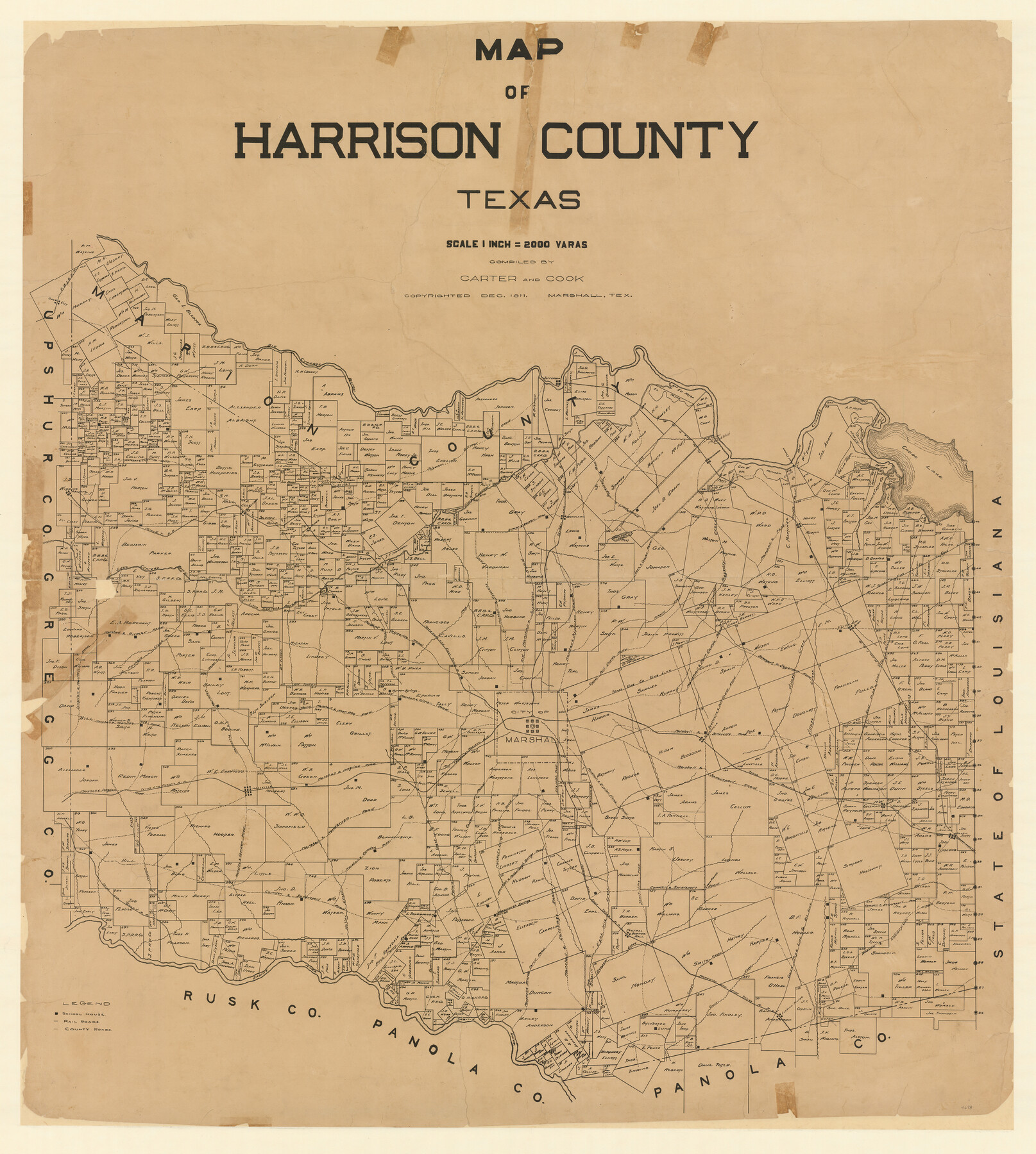
Map of Harrison County
-
Map/Doc
4698
-
Collection
General Map Collection
-
Object Dates
12/1911 (Creation Date)
-
People and Organizations
Carter and Cook of Marshall, Texas (Publisher)
Carter and Cook (Compiler)
-
Counties
Harrison
-
Subjects
County
-
Height x Width
43.8 x 39.8 inches
111.3 x 101.1 cm
-
Features
Short Line Road
Marshall and Jonesville Road
Marshall and Port Caddo Road
Scottsville and Port Caddo Road
Prewitt Creek
Haggerty Creek
Lake Cooper Road
Upper Port Caddo Road
Marshall and Elysian Fields Road
Camdem and Shreveport Road
Feutral
Scottsville
Quapaw Creek
Marshall and Board Ferry Road
Marshall and Carthage Road
Rosborough Springs
Rosborough Springs
Marshall and Rosborough Springs Road
Fire Notch Road
Marshall and Ewing Chapel Road
Marshall
Old Marshall and Jefferson Road
Jonesville
Eight Mile Creek
Camden Road
Marshall to Camden Road
Leigh
Highland Lake
Caddo Road
Shreveport Road
Gilmer Road
Jefferson Road
Waskon
Marshall and Jefferson Road
Jonesville and Swanson Landing Road
Marshall Road
Village Creek
Waskon and Elysian Fields Road
Coffeville Road
Elysian Fields
Blocker
Caney Creek
Caddo Creek
Shreveport and Jefferson Road
Longview and Harlton Road
Moccasin Creek
Marshall and Gilmer Road
Karnack
Marshall and Coffeville Road
Norwood
Port Caddo
Caddo Lake
Ray's Bluff
Midland Lake
Marshall and Noon Day Road
Woodlawn
Gilmer to Renton Road
Little Cypress Bayou
T&P
Jefferson
Jefferson to Gilmer Road
Big Cypress Bayou
Orr City
M&ET
MK&T
Harleton
Marshall to Cypress Road
Gilmer and Denton Road
Marshall and Shreveport Road
Rays Creek
Carter Ferry Road
Potters Creek
Carters Ferry
Rock Ferry Road
Hatler Creek
Pine Ridge
P&IO
Hallville and Harleton Road
Hallville
Mason Creek
Marshall and Henderson Road
Hallville and Camden Road
Ashland
Sabine River
T&G
Marshall and Longview Road
Part of: General Map Collection
St. Marks to Galveston - Sheet II

Print $20.00
- Digital $50.00
St. Marks to Galveston - Sheet II
1846
Size 26.5 x 40.5 inches
Map/Doc 97397
Swisher County Working Sketch Graphic Index

Print $20.00
- Digital $50.00
Swisher County Working Sketch Graphic Index
1941
Size 41.5 x 35.9 inches
Map/Doc 76707
Map of Clay County, Cooke Land District, formely(sic.) Fannin Land District

Print $20.00
- Digital $50.00
Map of Clay County, Cooke Land District, formely(sic.) Fannin Land District
1859
Size 30.2 x 19.0 inches
Map/Doc 1049
Jeff Davis County Sketch File 31

Print $34.00
- Digital $50.00
Jeff Davis County Sketch File 31
Size 10.6 x 8.4 inches
Map/Doc 28023
Maps of Gulf Intracoastal Waterway, Texas - Sabine River to the Rio Grande and connecting waterways including ship channels

Print $20.00
- Digital $50.00
Maps of Gulf Intracoastal Waterway, Texas - Sabine River to the Rio Grande and connecting waterways including ship channels
1966
Size 14.5 x 21.2 inches
Map/Doc 61989
Duval County Rolled Sketch 35

Print $20.00
- Digital $50.00
Duval County Rolled Sketch 35
1951
Size 23.5 x 17.0 inches
Map/Doc 5750
Guadalupe County Rolled Sketch 1

Print $20.00
- Digital $50.00
Guadalupe County Rolled Sketch 1
1954
Size 33.1 x 38.8 inches
Map/Doc 6044
Flight Mission No. CUG-2P, Frame 29, Kleberg County

Print $20.00
- Digital $50.00
Flight Mission No. CUG-2P, Frame 29, Kleberg County
1956
Size 18.6 x 22.4 inches
Map/Doc 86194
Flight Mission No. BRA-7M, Frame 4, Jefferson County

Print $20.00
- Digital $50.00
Flight Mission No. BRA-7M, Frame 4, Jefferson County
1953
Size 18.7 x 22.2 inches
Map/Doc 85455
Hale County Rolled Sketch 6

Print $20.00
- Digital $50.00
Hale County Rolled Sketch 6
1903
Size 35.0 x 28.9 inches
Map/Doc 6045
Cameron County Rolled Sketch 18

Print $64.00
- Digital $50.00
Cameron County Rolled Sketch 18
1970
Size 48.9 x 57.1 inches
Map/Doc 8571
San Jacinto County Sketch File 12a

Print $20.00
San Jacinto County Sketch File 12a
Size 12.8 x 14.3 inches
Map/Doc 35722
You may also like
Hudspeth County Rolled Sketch 33

Print $40.00
- Digital $50.00
Hudspeth County Rolled Sketch 33
Size 59.0 x 24.9 inches
Map/Doc 8345
Swisher County Rolled Sketch 7

Print $40.00
- Digital $50.00
Swisher County Rolled Sketch 7
1955
Size 65.0 x 43.5 inches
Map/Doc 9983
Matagorda Light to Aransas Pass

Print $20.00
- Digital $50.00
Matagorda Light to Aransas Pass
1988
Size 35.2 x 44.3 inches
Map/Doc 73404
Baylor County Aerial Photograph Index Sheet 1

Print $20.00
- Digital $50.00
Baylor County Aerial Photograph Index Sheet 1
1950
Size 21.4 x 17.4 inches
Map/Doc 83663
[Southern Pacific Rail Road Co. Blocks 15 and 16 in Mitchell, Sterling and Coke Counties]
![91838, [Southern Pacific Rail Road Co. Blocks 15 and 16 in Mitchell, Sterling and Coke Counties], Twichell Survey Records](https://historictexasmaps.com/wmedia_w700/maps/91838-1.tif.jpg)
Print $20.00
- Digital $50.00
[Southern Pacific Rail Road Co. Blocks 15 and 16 in Mitchell, Sterling and Coke Counties]
Size 34.5 x 29.2 inches
Map/Doc 91838
Duval County Sketch File 4c1

Print $4.00
- Digital $50.00
Duval County Sketch File 4c1
1874
Size 10.4 x 7.9 inches
Map/Doc 21286
Val Verde County Working Sketch 17

Print $20.00
- Digital $50.00
Val Verde County Working Sketch 17
1926
Size 16.5 x 27.8 inches
Map/Doc 72152
Map of Navarro County

Print $20.00
- Digital $50.00
Map of Navarro County
1858
Size 19.3 x 25.8 inches
Map/Doc 3912
Flight Mission No. BRE-3P, Frame 96, Nueces County

Print $20.00
- Digital $50.00
Flight Mission No. BRE-3P, Frame 96, Nueces County
1956
Size 18.3 x 22.2 inches
Map/Doc 86827
Blanco County Sketch File 37

Print $4.00
- Digital $50.00
Blanco County Sketch File 37
Size 8.7 x 14.1 inches
Map/Doc 14646
Flight Mission No. DQN-1K, Frame 31, Calhoun County

Print $20.00
- Digital $50.00
Flight Mission No. DQN-1K, Frame 31, Calhoun County
1953
Size 15.4 x 15.5 inches
Map/Doc 84136
[Central Garza County]
![92659, [Central Garza County], Twichell Survey Records](https://historictexasmaps.com/wmedia_w700/maps/92659-1.tif.jpg)
Print $20.00
- Digital $50.00
[Central Garza County]
1906
Size 28.0 x 33.1 inches
Map/Doc 92659