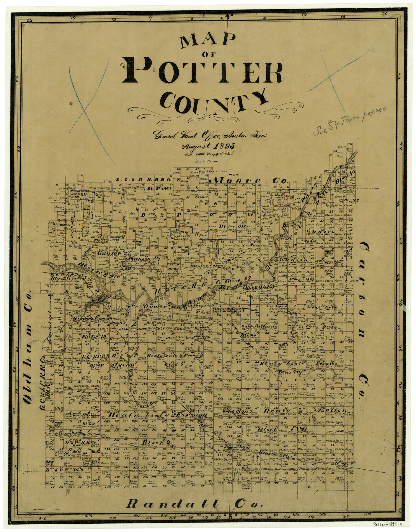
Map of Potter County
-
Map/Doc
3966
-
Collection
General Map Collection
-
Object Dates
8/1895 (Creation Date)
-
People and Organizations
Texas General Land Office (Publisher)
George L. Crum (Compiler)
George L. Crum (Draftsman)
-
Counties
Potter
-
Subjects
County
-
Height x Width
27.0 x 21.1 inches
68.6 x 53.6 cm
-
Features
Canadian River
Plum Creek
India Creek
Home Creek
John Ray Creek
Correll Creek
Sareta Lacruez [Creek]
Tecovas Creek
Niconas Creek
Hedrick's Creek
Bonito Creek
Amarillo Creek
Main Tecovas Creek
FW&DC
Amarillo
Part of: General Map Collection
Franklin County Sketch File 16

Print $6.00
- Digital $50.00
Franklin County Sketch File 16
Size 13.2 x 8.2 inches
Map/Doc 23023
Bosque County Sketch File 23

Print $6.00
- Digital $50.00
Bosque County Sketch File 23
1863
Size 10.2 x 8.2 inches
Map/Doc 14806
Lampasas County Boundary File 12

Print $6.00
- Digital $50.00
Lampasas County Boundary File 12
Size 11.0 x 8.6 inches
Map/Doc 56191
Crockett County Rolled Sketch 26

Print $20.00
- Digital $50.00
Crockett County Rolled Sketch 26
Size 33.7 x 40.9 inches
Map/Doc 5585
Brazos Santiago

Print $20.00
- Digital $50.00
Brazos Santiago
1884
Size 24.4 x 18.2 inches
Map/Doc 73030
Lubbock County Boundary File 8

Print $46.00
- Digital $50.00
Lubbock County Boundary File 8
Size 7.3 x 8.7 inches
Map/Doc 56525
Goliad County Sketch File 16

Print $40.00
- Digital $50.00
Goliad County Sketch File 16
Size 13.4 x 15.8 inches
Map/Doc 24247
Map of Chicago, Rock Island & Texas Railway through Montague and Wise Counties, Texas

Print $40.00
- Digital $50.00
Map of Chicago, Rock Island & Texas Railway through Montague and Wise Counties, Texas
1893
Size 20.2 x 124.5 inches
Map/Doc 64468
Brazos River, Brazos River Sheet 3

Print $6.00
- Digital $50.00
Brazos River, Brazos River Sheet 3
1926
Size 21.8 x 34.6 inches
Map/Doc 65296
Hutchinson County Rolled Sketch 16

Print $20.00
- Digital $50.00
Hutchinson County Rolled Sketch 16
1912
Size 27.5 x 30.2 inches
Map/Doc 6284
Victoria County Sketch File 11

Print $8.00
- Digital $50.00
Victoria County Sketch File 11
1985
Size 11.3 x 9.0 inches
Map/Doc 39536
Midland County Rolled Sketch RE

Print $20.00
- Digital $50.00
Midland County Rolled Sketch RE
1929
Size 43.4 x 32.8 inches
Map/Doc 6770
You may also like
Morris County Rolled Sketch 2A

Print $20.00
- Digital $50.00
Morris County Rolled Sketch 2A
Size 24.1 x 19.0 inches
Map/Doc 10279
Webb County Sketch File 58

Print $10.00
- Digital $50.00
Webb County Sketch File 58
1942
Size 14.4 x 8.9 inches
Map/Doc 39846
Stonewall County Working Sketch Graphic Index - sheet B

Print $20.00
- Digital $50.00
Stonewall County Working Sketch Graphic Index - sheet B
1933
Size 43.7 x 36.6 inches
Map/Doc 83172
Angelina County Working Sketch 37

Print $20.00
- Digital $50.00
Angelina County Working Sketch 37
1958
Size 25.7 x 19.1 inches
Map/Doc 67120
[Surrounding McCrummens Second Addition]
![92839, [Surrounding McCrummens Second Addition], Twichell Survey Records](https://historictexasmaps.com/wmedia_w700/maps/92839-1.tif.jpg)
Print $20.00
- Digital $50.00
[Surrounding McCrummens Second Addition]
Size 31.2 x 33.1 inches
Map/Doc 92839
Flight Mission No. DCL-5C, Frame 77, Kenedy County

Print $20.00
- Digital $50.00
Flight Mission No. DCL-5C, Frame 77, Kenedy County
1943
Size 18.5 x 22.4 inches
Map/Doc 85860
Cooke County Working Sketch 30

Print $20.00
- Digital $50.00
Cooke County Working Sketch 30
1979
Size 26.6 x 28.4 inches
Map/Doc 68267
Block 10, Deshazo, Borden County

Print $20.00
- Digital $50.00
Block 10, Deshazo, Borden County
Size 18.3 x 25.5 inches
Map/Doc 92127
Rusk County Sketch File 35

Print $6.00
Rusk County Sketch File 35
1950
Size 11.3 x 8.8 inches
Map/Doc 35573
Floyd County Sketch File 12

Print $10.00
- Digital $50.00
Floyd County Sketch File 12
1913
Size 10.8 x 8.8 inches
Map/Doc 22708
Concho County Sketch File 37

Print $20.00
- Digital $50.00
Concho County Sketch File 37
1938
Size 18.7 x 29.1 inches
Map/Doc 11162
Flight Mission No. DCL-5C, Frame 25, Kenedy County

Print $20.00
- Digital $50.00
Flight Mission No. DCL-5C, Frame 25, Kenedy County
1943
Size 18.4 x 22.3 inches
Map/Doc 85837