Midland County Rolled Sketch RE
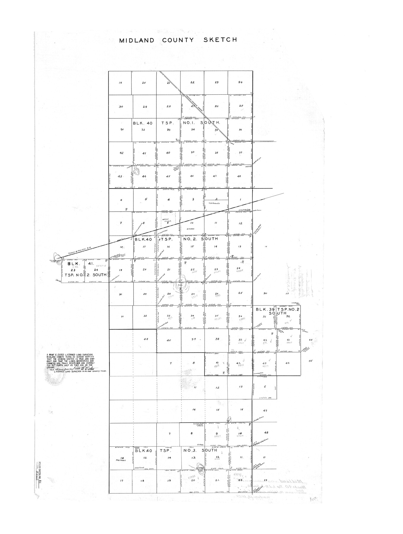
Midland County sketch [showing Block 40, T-1-S, T-2-S, and part of T-3-S]
-
Map/Doc
6770
-
Collection
General Map Collection
-
Object Dates
1929/6/10 (Creation Date)
1929/6/13 (File Date)
-
People and Organizations
Robt. E. Estes (Surveyor/Engineer)
-
Counties
Midland
-
Subjects
Surveying Rolled Sketch
-
Height x Width
43.4 x 32.8 inches
110.2 x 83.3 cm
Part of: General Map Collection
Hemphill County Working Sketch 37

Print $20.00
- Digital $50.00
Hemphill County Working Sketch 37
1981
Size 28.6 x 24.0 inches
Map/Doc 66132
Kimble County Working Sketch 64

Print $20.00
- Digital $50.00
Kimble County Working Sketch 64
1964
Size 15.1 x 16.9 inches
Map/Doc 70132
Flight Mission No. CLL-1N, Frame 102, Willacy County

Print $20.00
- Digital $50.00
Flight Mission No. CLL-1N, Frame 102, Willacy County
1954
Size 18.3 x 22.0 inches
Map/Doc 87036
Presidio County Rolled Sketch 79

Print $20.00
- Digital $50.00
Presidio County Rolled Sketch 79
Size 22.2 x 27.0 inches
Map/Doc 7365
Dimmit County Working Sketch 37

Print $20.00
- Digital $50.00
Dimmit County Working Sketch 37
1962
Size 28.9 x 25.6 inches
Map/Doc 68698
Terrell County Sketch File 33

Print $20.00
- Digital $50.00
Terrell County Sketch File 33
1924
Size 18.2 x 27.6 inches
Map/Doc 12427
Stonewall County Rolled Sketch 20

Print $40.00
- Digital $50.00
Stonewall County Rolled Sketch 20
Size 36.7 x 55.7 inches
Map/Doc 49129
Crockett County Working Sketch 65

Print $20.00
- Digital $50.00
Crockett County Working Sketch 65
1957
Size 32.3 x 38.0 inches
Map/Doc 68398
Moore County Working Sketch 3

Print $20.00
- Digital $50.00
Moore County Working Sketch 3
1910
Size 12.2 x 17.4 inches
Map/Doc 71185
Montgomery County Working Sketch 48

Print $20.00
- Digital $50.00
Montgomery County Working Sketch 48
1958
Size 24.4 x 32.1 inches
Map/Doc 71155
Montague County Boundary File 3

Print $42.00
- Digital $50.00
Montague County Boundary File 3
Size 9.0 x 13.6 inches
Map/Doc 57434
Castro County Sketch File 10

Print $6.00
- Digital $50.00
Castro County Sketch File 10
1916
Size 8.2 x 5.4 inches
Map/Doc 17501
You may also like
Flight Mission No. CRC-5R, Frame 43, Chambers County

Print $20.00
- Digital $50.00
Flight Mission No. CRC-5R, Frame 43, Chambers County
1956
Size 18.6 x 22.3 inches
Map/Doc 84962
Burleson County Working Sketch 12

Print $20.00
- Digital $50.00
Burleson County Working Sketch 12
1980
Size 20.6 x 12.0 inches
Map/Doc 67731
Dickens County Boundary File 3

Print $28.00
- Digital $50.00
Dickens County Boundary File 3
Size 14.1 x 8.8 inches
Map/Doc 52541
Menard County Boundary File 1a

Print $8.00
- Digital $50.00
Menard County Boundary File 1a
Size 12.7 x 8.2 inches
Map/Doc 57042
Houston County Rolled Sketch 3

Print $57.00
- Digital $50.00
Houston County Rolled Sketch 3
1935
Size 23.5 x 23.4 inches
Map/Doc 6226
Cooke County Sketch File 2

Print $20.00
- Digital $50.00
Cooke County Sketch File 2
Size 9.6 x 21.6 inches
Map/Doc 11169
Foard County Rolled Sketch 16

Print $40.00
- Digital $50.00
Foard County Rolled Sketch 16
1889
Size 36.9 x 72.8 inches
Map/Doc 8893
McMullen County

Print $20.00
- Digital $50.00
McMullen County
1967
Size 40.7 x 27.8 inches
Map/Doc 77363
Webb County Boundary File 7

Print $98.00
- Digital $50.00
Webb County Boundary File 7
Size 14.2 x 8.7 inches
Map/Doc 59809
Revolutionary Map of Texas, 1836

Print $27.06
Revolutionary Map of Texas, 1836
1986
Size 32.7 x 26.7 inches
Map/Doc 89022
Eastland County Working Sketch 39

Print $20.00
- Digital $50.00
Eastland County Working Sketch 39
1969
Size 43.0 x 37.4 inches
Map/Doc 68820
Sterling County

Print $20.00
- Digital $50.00
Sterling County
1926
Size 47.8 x 35.2 inches
Map/Doc 16820