Cameron County Sketch File 15
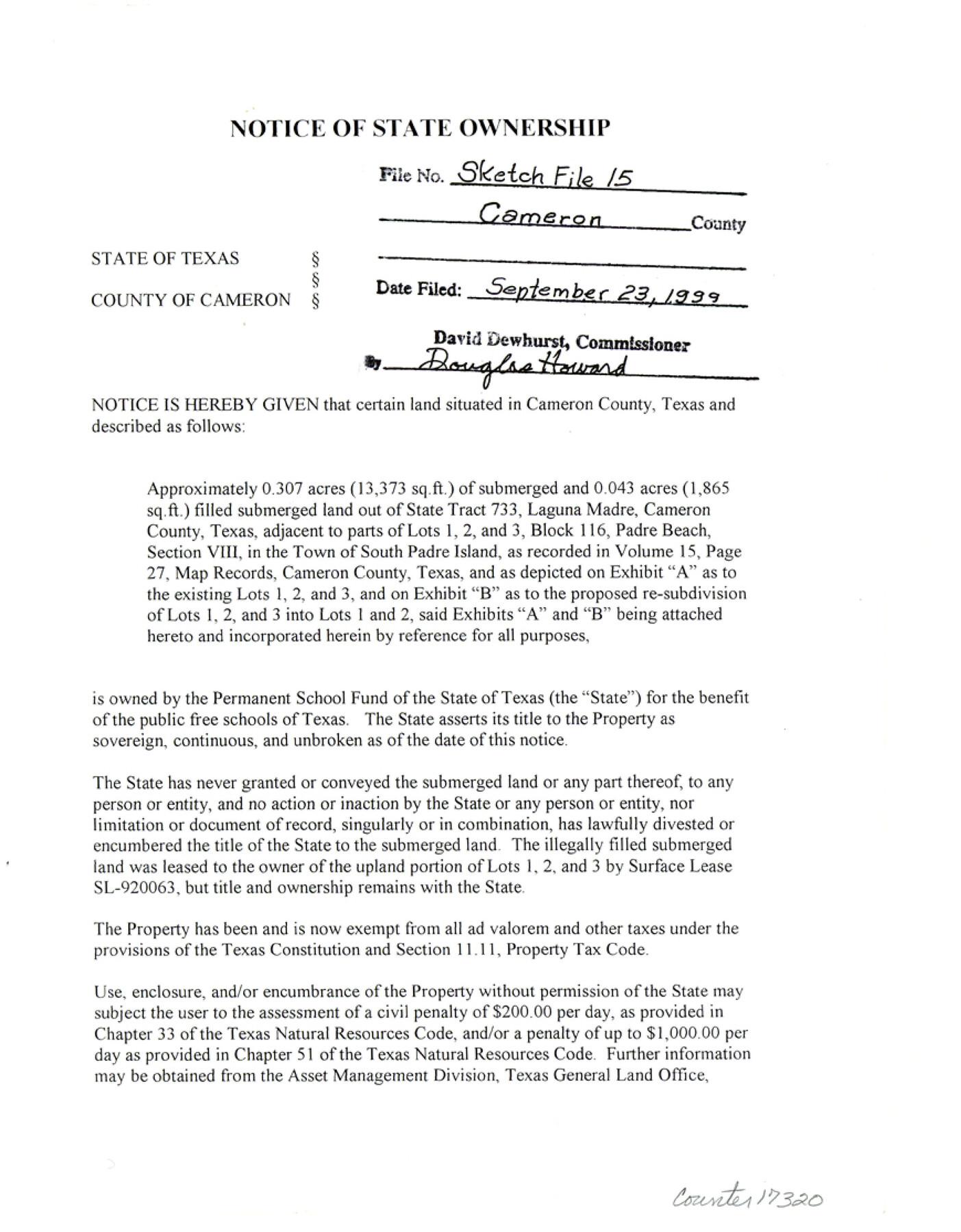
[Notice of State ownership of approximately 0.307 acres of submerged and 0.043 acres filled submerged land out of State Tract 733, Laguna Madre, adjacent to parts of Lots 1, 2, and 3, Block 116, Padre Beach Section VIII in the town of South Padre Island]
-
Map/Doc
17320
-
Collection
General Map Collection
-
Object Dates
1999/9/7 (Creation Date)
1999/9/23 (File Date)
-
People and Organizations
David Dewhurst (GLO Commissioner)
-
Counties
Cameron
-
Subjects
Surveying Sketch File
-
Height x Width
11.2 x 8.7 inches
28.4 x 22.1 cm
-
Medium
paper, print
-
Features
Laguna Madre
South Padre Island
Part of: General Map Collection
Baylor County Rolled Sketch 10

Print $20.00
- Digital $50.00
Baylor County Rolled Sketch 10
Size 28.0 x 14.0 inches
Map/Doc 5127
Surveyor's Watercourse Report 2

Print $42.00
Surveyor's Watercourse Report 2
2025
Size 11.0 x 8.5 inches
Map/Doc 97512
Newton County Working Sketch 38

Print $20.00
- Digital $50.00
Newton County Working Sketch 38
1961
Size 36.8 x 29.2 inches
Map/Doc 71284
Flight Mission No. DQO-3K, Frame 14, Galveston County

Print $20.00
- Digital $50.00
Flight Mission No. DQO-3K, Frame 14, Galveston County
1952
Size 18.8 x 22.4 inches
Map/Doc 85055
PSL Field Notes for Block JKL in Hudspeth County

PSL Field Notes for Block JKL in Hudspeth County
Map/Doc 81658
Fort Bend County State Real Property Sketch 12

Print $40.00
- Digital $50.00
Fort Bend County State Real Property Sketch 12
1986
Size 43.2 x 35.0 inches
Map/Doc 61686
Flight Mission No. DQN-1K, Frame 109, Calhoun County

Print $20.00
- Digital $50.00
Flight Mission No. DQN-1K, Frame 109, Calhoun County
1953
Size 18.4 x 22.1 inches
Map/Doc 84176
Runnels County Rolled Sketch 38

Print $20.00
- Digital $50.00
Runnels County Rolled Sketch 38
Size 33.3 x 46.7 inches
Map/Doc 7525
Atascosa County Working Sketch 31

Print $20.00
- Digital $50.00
Atascosa County Working Sketch 31
1981
Size 21.4 x 16.6 inches
Map/Doc 67227

Sterling County Rolled Sketch 25

Print $20.00
- Digital $50.00
Sterling County Rolled Sketch 25
Size 31.4 x 35.3 inches
Map/Doc 9955
Zavala County Working Sketch 1

Print $20.00
- Digital $50.00
Zavala County Working Sketch 1
Size 21.2 x 16.3 inches
Map/Doc 62076
You may also like
Wheeler County

Print $20.00
- Digital $50.00
Wheeler County
1932
Size 41.7 x 38.0 inches
Map/Doc 73322
Andrews County Rolled Sketch 24

Print $20.00
- Digital $50.00
Andrews County Rolled Sketch 24
1946
Size 43.0 x 35.8 inches
Map/Doc 8397
Brewster County Sketch File S-29a

Print $4.00
- Digital $50.00
Brewster County Sketch File S-29a
1972
Size 9.1 x 14.5 inches
Map/Doc 15848
Map of Padre Island

Print $40.00
- Digital $50.00
Map of Padre Island
Size 74.6 x 22.8 inches
Map/Doc 76020
New Map of Texas prepared and published for the Bureau of Immigration of the State of Texas

Print $20.00
- Digital $50.00
New Map of Texas prepared and published for the Bureau of Immigration of the State of Texas
1875
Size 15.8 x 18.3 inches
Map/Doc 93626
Cherokee County Sketch File 25

Print $4.00
- Digital $50.00
Cherokee County Sketch File 25
1852
Size 12.8 x 8.1 inches
Map/Doc 18167
Real County Rolled Sketch 18

Print $20.00
- Digital $50.00
Real County Rolled Sketch 18
Size 22.0 x 27.9 inches
Map/Doc 7460
Map of Power and Hewetson Colony

Print $20.00
- Digital $50.00
Map of Power and Hewetson Colony
1841
Size 34.8 x 24.3 inches
Map/Doc 1950
Flight Mission No. CGI-4N, Frame 29, Cameron County

Print $20.00
- Digital $50.00
Flight Mission No. CGI-4N, Frame 29, Cameron County
1954
Size 18.6 x 22.4 inches
Map/Doc 84662
La Salle County Rolled Sketch 33

Print $20.00
- Digital $50.00
La Salle County Rolled Sketch 33
2015
Size 17.6 x 27.6 inches
Map/Doc 95306
Runnels County Rolled Sketch 45

Print $20.00
- Digital $50.00
Runnels County Rolled Sketch 45
1954
Size 32.1 x 41.0 inches
Map/Doc 7532
Blanco County Working Sketch 25

Print $20.00
- Digital $50.00
Blanco County Working Sketch 25
1966
Size 24.8 x 24.8 inches
Map/Doc 67385