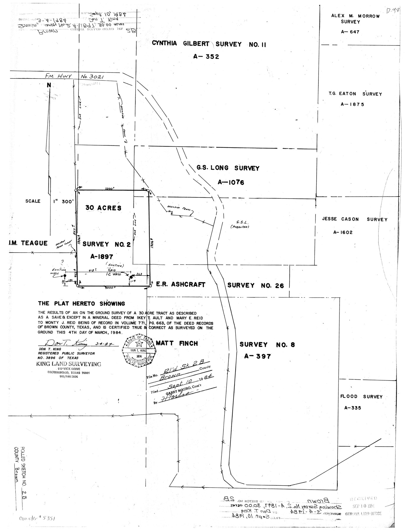
Brown County Rolled Sketch 2B
The plat hereto showing the results of an on the ground survey of a 30 acre tract as described as a save & except in a mineral deed from Ikey T. Ault and Mary E. Reid to Monty J. Reid
-
Map/Doc
5351
-
Collection
General Map Collection
-
Object Dates
1984/3/4 (Creation Date)
1984/9/10 (File Date)
-
People and Organizations
Don T. King (Surveyor/Engineer)
-
Counties
Brown
-
Subjects
Surveying Rolled Sketch
-
Height x Width
24.3 x 18.6 inches
61.7 x 47.2 cm
-
Medium
mylar, print
-
Scale
1" = 300 feet
Part of: General Map Collection
Dimmit County Boundary File 7

Print $14.00
- Digital $50.00
Dimmit County Boundary File 7
Size 12.8 x 8.4 inches
Map/Doc 52590
Runnels County Sketch File 21A

Print $20.00
Runnels County Sketch File 21A
1886
Size 17.5 x 20.5 inches
Map/Doc 12256
Van Zandt County Sketch File 33

Print $8.00
- Digital $50.00
Van Zandt County Sketch File 33
1860
Size 12.4 x 7.8 inches
Map/Doc 39469
Stephens County Rolled Sketch 3

Print $20.00
- Digital $50.00
Stephens County Rolled Sketch 3
1919
Size 34.9 x 19.6 inches
Map/Doc 7840
Newton County Sketch File 9

Print $4.00
- Digital $50.00
Newton County Sketch File 9
Size 9.8 x 8.3 inches
Map/Doc 32378
Aransas County Rolled Sketch 28

Print $20.00
- Digital $50.00
Aransas County Rolled Sketch 28
1987
Size 24.5 x 30.9 inches
Map/Doc 77496
United States of America, compiled from the latest & best authorities by John Melish, 1820

Print $20.00
- Digital $50.00
United States of America, compiled from the latest & best authorities by John Melish, 1820
1820
Size 16.7 x 20.2 inches
Map/Doc 89220
Runnels County Boundary File 1b

Print $24.00
- Digital $50.00
Runnels County Boundary File 1b
Size 15.7 x 8.3 inches
Map/Doc 58514
Crockett County Sketch File 26

Print $58.00
- Digital $50.00
Crockett County Sketch File 26
1880
Size 8.7 x 7.2 inches
Map/Doc 19706
Irion County Sketch File 3

Print $20.00
- Digital $50.00
Irion County Sketch File 3
1891
Size 22.4 x 22.1 inches
Map/Doc 11823
Austin County Rolled Sketch 7

Print $47.00
- Digital $50.00
Austin County Rolled Sketch 7
1974
Size 10.4 x 15.3 inches
Map/Doc 42340
Comal County Sketch File 3

Print $8.00
- Digital $50.00
Comal County Sketch File 3
1853
Size 4.4 x 8.4 inches
Map/Doc 18999
You may also like
Bee County Working Sketch 27

Print $20.00
- Digital $50.00
Bee County Working Sketch 27
1988
Size 27.0 x 23.4 inches
Map/Doc 67277
Nacogdoches County Working Sketch 11

Print $20.00
- Digital $50.00
Nacogdoches County Working Sketch 11
1985
Size 41.1 x 28.0 inches
Map/Doc 71227
Limestone County Working Sketch 27

Print $20.00
- Digital $50.00
Limestone County Working Sketch 27
2008
Size 34.4 x 35.6 inches
Map/Doc 88767
[Township 4 North, Block 33]
![91216, [Township 4 North, Block 33], Twichell Survey Records](https://historictexasmaps.com/wmedia_w700/maps/91216-1.tif.jpg)
Print $3.00
- Digital $50.00
[Township 4 North, Block 33]
Size 11.3 x 12.0 inches
Map/Doc 91216
Midland County Sketch File 14

Print $8.00
- Digital $50.00
Midland County Sketch File 14
1951
Size 10.9 x 8.7 inches
Map/Doc 31578
[Surveying Sketch of Heirs of Wm Neil, J.J. Hall, Robert Sikes, et al in Hutchinson County, Texas]
![75778, [Surveying Sketch of Heirs of Wm Neil, J.J. Hall, Robert Sikes, et al in Hutchinson County, Texas], Maddox Collection](https://historictexasmaps.com/wmedia_w700/maps/75778-1.tif.jpg)
Print $20.00
- Digital $50.00
[Surveying Sketch of Heirs of Wm Neil, J.J. Hall, Robert Sikes, et al in Hutchinson County, Texas]
Size 15.6 x 20.5 inches
Map/Doc 75778
Angelina County

Print $40.00
- Digital $50.00
Angelina County
1899
Size 38.9 x 49.9 inches
Map/Doc 4873
[Gulf Coast of Texas]
![72701, [Gulf Coast of Texas], General Map Collection](https://historictexasmaps.com/wmedia_w700/maps/72701.tif.jpg)
Print $20.00
- Digital $50.00
[Gulf Coast of Texas]
1881
Size 18.2 x 28.5 inches
Map/Doc 72701
Cherokee County Working Sketch 6

Print $20.00
- Digital $50.00
Cherokee County Working Sketch 6
1953
Size 40.9 x 35.1 inches
Map/Doc 67961
Chambers County Sketch File 22

Print $8.00
- Digital $50.00
Chambers County Sketch File 22
Size 12.2 x 7.6 inches
Map/Doc 17594
Wichita County Sketch File 25

Print $20.00
- Digital $50.00
Wichita County Sketch File 25
1919
Size 17.6 x 22.3 inches
Map/Doc 12685
Mexico y sus Cercanias

Print $20.00
- Digital $50.00
Mexico y sus Cercanias
Size 26.1 x 34.2 inches
Map/Doc 96809