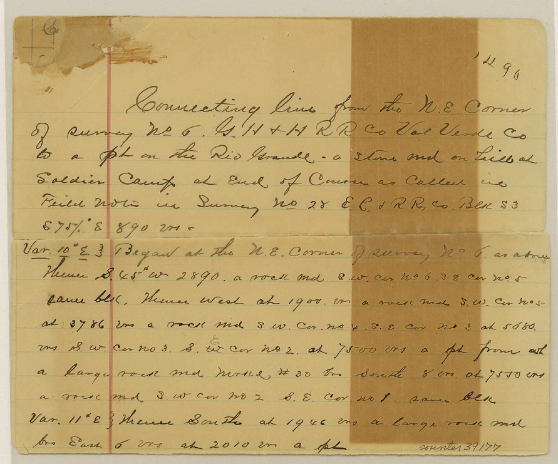
Val Verde County Sketch File 6a
[Connecting line from northeast corner of survey 6, G. H. & H. R.R. Co. to a point on the Rio Grande]
-
Map/Doc
39191
-
Collection
General Map Collection
-
Object Dates
7/29/1895 (Creation Date)
-
People and Organizations
John K. Peirce (Surveyor/Engineer)
-
Counties
Val Verde
-
Subjects
Surveying Sketch File
-
Height x Width
7.4 x 8.7 inches
18.8 x 22.1 cm
-
Medium
paper, manuscript
-
Features
Rio Grande
Soldier's Camp
Meyer's Canon
Cedar Canon
Part of: General Map Collection
Edwards County Working Sketch 134

Print $40.00
- Digital $50.00
Edwards County Working Sketch 134
1986
Size 29.4 x 54.2 inches
Map/Doc 69010
Van Zandt County Sketch File 26

Print $4.00
- Digital $50.00
Van Zandt County Sketch File 26
1858
Size 6.7 x 7.9 inches
Map/Doc 39445
El Paso County Working Sketch 7

Print $20.00
- Digital $50.00
El Paso County Working Sketch 7
1928
Size 25.7 x 16.9 inches
Map/Doc 69029
Map of The Surveyed Part of Peters Colony Texas

Print $40.00
- Digital $50.00
Map of The Surveyed Part of Peters Colony Texas
1852
Size 53.0 x 28.1 inches
Map/Doc 1964
Maps of Gulf Intracoastal Waterway, Texas - Sabine River to the Rio Grande and connecting waterways including ship channels

Print $20.00
- Digital $50.00
Maps of Gulf Intracoastal Waterway, Texas - Sabine River to the Rio Grande and connecting waterways including ship channels
1966
Size 14.5 x 22.3 inches
Map/Doc 61948
Orange County Rolled Sketch 32

Print $20.00
- Digital $50.00
Orange County Rolled Sketch 32
1982
Size 33.6 x 22.5 inches
Map/Doc 7188
Dimmit County Boundary File 3

Print $12.00
- Digital $50.00
Dimmit County Boundary File 3
Size 14.4 x 8.9 inches
Map/Doc 52566
Right of Way and Track Map, International & Gt. Northern Ry. operated by the International & Gt. Northern Ry. Co. Gulf Division, Mineola Branch

Print $40.00
- Digital $50.00
Right of Way and Track Map, International & Gt. Northern Ry. operated by the International & Gt. Northern Ry. Co. Gulf Division, Mineola Branch
1917
Size 25.2 x 120.8 inches
Map/Doc 64703
Harris County Rolled Sketch 88

Print $20.00
- Digital $50.00
Harris County Rolled Sketch 88
1937
Size 34.9 x 22.7 inches
Map/Doc 6126
Real County Sketch File 11

Print $8.00
- Digital $50.00
Real County Sketch File 11
1932
Size 11.2 x 8.8 inches
Map/Doc 35065
Colorado River, LaGrange Sheet

Print $20.00
- Digital $50.00
Colorado River, LaGrange Sheet
1934
Size 37.8 x 32.9 inches
Map/Doc 65302
Jack County Working Sketch 25

Print $20.00
- Digital $50.00
Jack County Working Sketch 25
2012
Size 32.7 x 24.9 inches
Map/Doc 93409
You may also like
Coryell County

Print $20.00
- Digital $50.00
Coryell County
1936
Size 44.6 x 40.1 inches
Map/Doc 77249
Railroad Track Map, H&TCRRCo., Falls County, Texas

Print $4.00
- Digital $50.00
Railroad Track Map, H&TCRRCo., Falls County, Texas
1918
Size 11.8 x 18.5 inches
Map/Doc 62860
Liberty County Working Sketch 16

Print $20.00
- Digital $50.00
Liberty County Working Sketch 16
1936
Size 24.1 x 34.7 inches
Map/Doc 70475
University of Texas System University Lands

Print $20.00
- Digital $50.00
University of Texas System University Lands
Size 23.0 x 17.5 inches
Map/Doc 93240
Flight Mission No. BQR-13K, Frame 28, Brazoria County

Print $20.00
- Digital $50.00
Flight Mission No. BQR-13K, Frame 28, Brazoria County
1952
Size 18.6 x 22.4 inches
Map/Doc 84076
Clay County Boundary File 7

Print $14.00
- Digital $50.00
Clay County Boundary File 7
Size 14.3 x 8.8 inches
Map/Doc 51377
Hartley County Working Sketch 2

Print $20.00
- Digital $50.00
Hartley County Working Sketch 2
1920
Size 41.8 x 30.7 inches
Map/Doc 66052
Atascosa County Working Sketch 23

Print $40.00
- Digital $50.00
Atascosa County Working Sketch 23
1958
Size 38.8 x 57.1 inches
Map/Doc 68434
Plano del Presidio de Bahia dela Espiritu Santo dependite dela Governacion de los Tejas situado en 29 grad. Y 39 min. de latitud boreal y 277° y 54' dela long. contados desde el Merid. De Tenerife

Plano del Presidio de Bahia dela Espiritu Santo dependite dela Governacion de los Tejas situado en 29 grad. Y 39 min. de latitud boreal y 277° y 54' dela long. contados desde el Merid. De Tenerife
1768
Size 16.7 x 21.0 inches
Map/Doc 96565
Amistad International Reservoir on Rio Grande 70

Print $20.00
- Digital $50.00
Amistad International Reservoir on Rio Grande 70
1949
Size 28.4 x 39.7 inches
Map/Doc 73356
Harris County Sketch File 101

Print $104.00
- Digital $50.00
Harris County Sketch File 101
1991
Size 11.3 x 8.9 inches
Map/Doc 25873
Hutchinson County Rolled Sketch 37A

Print $40.00
- Digital $50.00
Hutchinson County Rolled Sketch 37A
1950
Size 26.0 x 51.1 inches
Map/Doc 9247