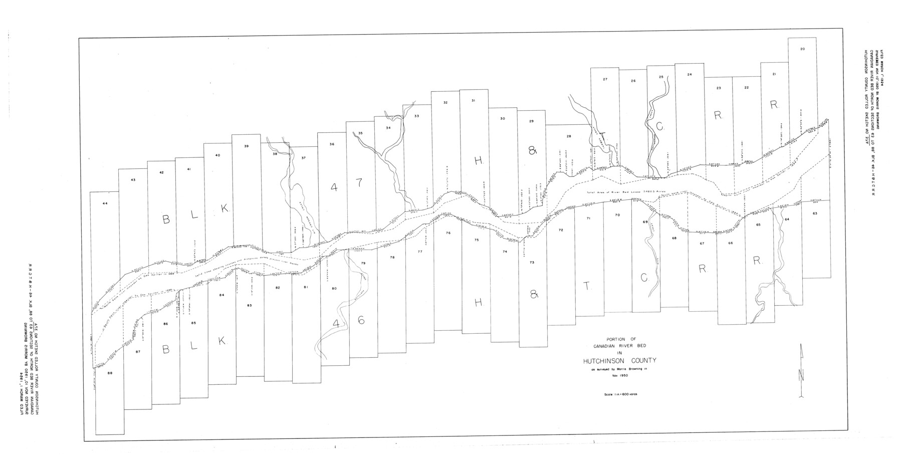
Hutchinson County Rolled Sketch 37A
Portion of Canadian River Bed in Hutchinson County
-
Map/Doc
9247
-
Collection
General Map Collection
-
Object Dates
11/1950 (Creation Date)
3/1/1954 (File Date)
-
People and Organizations
Morris Browning (Surveyor/Engineer)
-
Counties
Hutchinson
-
Subjects
Surveying Rolled Sketch
-
Height x Width
26.0 x 51.1 inches
66.0 x 129.8 cm
-
Scale
1" = 600 varas
Part of: General Map Collection
Van Zandt County

Print $20.00
- Digital $50.00
Van Zandt County
1972
Size 47.6 x 42.0 inches
Map/Doc 95662
Culberson County Working Sketch 27

Print $40.00
- Digital $50.00
Culberson County Working Sketch 27
1952
Size 22.2 x 53.4 inches
Map/Doc 68480
Cherokee County Rolled Sketch 3

Print $40.00
- Digital $50.00
Cherokee County Rolled Sketch 3
1955
Size 55.5 x 35.2 inches
Map/Doc 8597
Swisher County Sketch File 6

Print $20.00
- Digital $50.00
Swisher County Sketch File 6
Size 15.4 x 12.1 inches
Map/Doc 12404
Baylor County Sketch File 32

Print $10.00
- Digital $50.00
Baylor County Sketch File 32
Size 10.2 x 8.2 inches
Map/Doc 14238
Jeff Davis County Sketch File 2

Print $4.00
- Digital $50.00
Jeff Davis County Sketch File 2
1888
Size 10.7 x 8.8 inches
Map/Doc 27888
Rio Grande, Laguna Atascosa Sheet

Print $20.00
- Digital $50.00
Rio Grande, Laguna Atascosa Sheet
1935
Size 37.4 x 37.6 inches
Map/Doc 65112
Jasper County Working Sketch 32

Print $20.00
- Digital $50.00
Jasper County Working Sketch 32
1993
Size 18.7 x 22.7 inches
Map/Doc 66494
[Surveys in the Bexar District along the Colorado River]
![38, [Surveys in the Bexar District along the Colorado River], General Map Collection](https://historictexasmaps.com/wmedia_w700/maps/38.tif.jpg)
Print $2.00
- Digital $50.00
[Surveys in the Bexar District along the Colorado River]
1841
Size 7.2 x 9.1 inches
Map/Doc 38
Flight Mission No. CUG-2P, Frame 23, Kleberg County

Print $20.00
- Digital $50.00
Flight Mission No. CUG-2P, Frame 23, Kleberg County
1956
Size 18.6 x 22.3 inches
Map/Doc 86187
Glasscock County Working Sketch 16

Print $40.00
- Digital $50.00
Glasscock County Working Sketch 16
1984
Size 61.2 x 44.0 inches
Map/Doc 63189
Young County Sketch File 9a

Print $4.00
- Digital $50.00
Young County Sketch File 9a
1875
Size 12.9 x 8.3 inches
Map/Doc 40866
You may also like
Working Sketch in Archer County

Print $20.00
- Digital $50.00
Working Sketch in Archer County
1924
Size 30.7 x 42.4 inches
Map/Doc 89980
Victoria County Working Sketch 6

Print $20.00
- Digital $50.00
Victoria County Working Sketch 6
1944
Size 36.3 x 33.9 inches
Map/Doc 72276
Flight Mission No. DIX-7P, Frame 14, Aransas County

Print $20.00
- Digital $50.00
Flight Mission No. DIX-7P, Frame 14, Aransas County
1956
Size 18.8 x 22.6 inches
Map/Doc 83866
The Republic County of Nacogdoches. December 6, 1841

Print $20.00
The Republic County of Nacogdoches. December 6, 1841
2020
Size 15.9 x 21.8 inches
Map/Doc 96246
Culberson County Working Sketch Graphic Index, Sheet B (Sketches 41 to Most Recent)

Print $40.00
- Digital $50.00
Culberson County Working Sketch Graphic Index, Sheet B (Sketches 41 to Most Recent)
1943
Size 52.5 x 32.5 inches
Map/Doc 76515

Chambers County

Print $20.00
- Digital $50.00
Chambers County
1862
Size 20.2 x 27.8 inches
Map/Doc 3381
Harrison County Working Sketch 2

Print $20.00
- Digital $50.00
Harrison County Working Sketch 2
1940
Size 40.3 x 36.0 inches
Map/Doc 66022
Reeves County Rolled Sketch 5

Print $20.00
- Digital $50.00
Reeves County Rolled Sketch 5
Size 34.7 x 28.0 inches
Map/Doc 7477
Madison County Working Sketch 5

Print $20.00
- Digital $50.00
Madison County Working Sketch 5
1981
Size 24.0 x 24.1 inches
Map/Doc 70767
Atascosa County Sketch File 10

Print $4.00
- Digital $50.00
Atascosa County Sketch File 10
Size 12.1 x 7.7 inches
Map/Doc 13765
Webb County Sketch File 59

Print $8.00
- Digital $50.00
Webb County Sketch File 59
1943
Size 14.4 x 9.0 inches
Map/Doc 39851