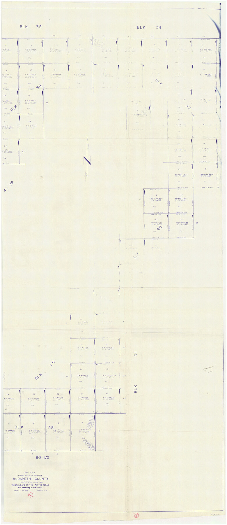
Hudspeth County Working Sketch 30
-
Map/Doc
66313
-
Collection
General Map Collection
-
Object Dates
5/15/1972 (Edition Date)
-
People and Organizations
Elbert Menzel (Draftsman)
-
Counties
Hudspeth
-
Subjects
Surveying Working Sketch
-
Height x Width
80.4 x 36.0 inches
204.2 x 91.4 cm
-
Scale
1" = 500 varas
-
Comments
Segment 2; for segment 1 see counter No. 66312.
Related maps
Hudspeth County Working Sketch 30

Print $40.00
- Digital $50.00
Hudspeth County Working Sketch 30
1972
Size 80.8 x 42.2 inches
Map/Doc 66312
Part of: General Map Collection
[Sketch for Mineral Application 24072, San Jacinto River]
![65607, [Sketch for Mineral Application 24072, San Jacinto River], General Map Collection](https://historictexasmaps.com/wmedia_w700/maps/65607.tif.jpg)
Print $20.00
- Digital $50.00
[Sketch for Mineral Application 24072, San Jacinto River]
1929
Size 23.3 x 17.8 inches
Map/Doc 65607
Jasper County Sketch File 5

Print $4.00
- Digital $50.00
Jasper County Sketch File 5
Size 8.4 x 12.1 inches
Map/Doc 27770
Brown County Sketch File 31

Print $6.00
- Digital $50.00
Brown County Sketch File 31
Size 17.0 x 11.0 inches
Map/Doc 16643
Flight Mission No. DQO-2K, Frame 135, Galveston County

Print $20.00
- Digital $50.00
Flight Mission No. DQO-2K, Frame 135, Galveston County
1952
Size 18.7 x 22.5 inches
Map/Doc 85032
Hudspeth County Sketch File 12

Print $10.00
- Digital $50.00
Hudspeth County Sketch File 12
1901
Size 14.2 x 8.7 inches
Map/Doc 26924
Eastland County Working Sketch 24

Print $20.00
- Digital $50.00
Eastland County Working Sketch 24
1922
Size 36.1 x 27.1 inches
Map/Doc 68805
Brazoria County Sketch File 24

Print $6.00
- Digital $50.00
Brazoria County Sketch File 24
1868
Size 11.3 x 10.4 inches
Map/Doc 15022
Rockwall County

Print $20.00
- Digital $50.00
Rockwall County
1941
Size 28.7 x 23.0 inches
Map/Doc 73277
San Jacinto River and Tributaries, Texas - Survey of 1939

Print $20.00
- Digital $50.00
San Jacinto River and Tributaries, Texas - Survey of 1939
1939
Size 27.7 x 40.5 inches
Map/Doc 60310
Hemphill County Working Sketch Graphic Index - sheet 1

Print $20.00
- Digital $50.00
Hemphill County Working Sketch Graphic Index - sheet 1
1899
Size 40.1 x 38.2 inches
Map/Doc 76574
Young County Sketch File 10

Print $20.00
- Digital $50.00
Young County Sketch File 10
Size 14.1 x 17.7 inches
Map/Doc 12711
Maps & Lists Showing Prison Lands (Oil & Gas) Leased as of June 1955

Digital $50.00
Maps & Lists Showing Prison Lands (Oil & Gas) Leased as of June 1955
Size 11.4 x 7.1 inches
Map/Doc 62865
You may also like
Caldwell County Working Sketch Graphic Index

Print $20.00
- Digital $50.00
Caldwell County Working Sketch Graphic Index
1935
Size 36.7 x 41.3 inches
Map/Doc 76483
Duval County Sketch File 13

Print $4.00
- Digital $50.00
Duval County Sketch File 13
1876
Size 8.5 x 10.3 inches
Map/Doc 21306
Pecos County Rolled Sketch 29

Print $40.00
- Digital $50.00
Pecos County Rolled Sketch 29
1890
Size 27.3 x 49.9 inches
Map/Doc 9690
Flight Mission No. BRA-9M, Frame 65, Jefferson County

Print $20.00
- Digital $50.00
Flight Mission No. BRA-9M, Frame 65, Jefferson County
1953
Size 18.6 x 22.2 inches
Map/Doc 85648
Smith County Rolled Sketch 6B

Print $40.00
- Digital $50.00
Smith County Rolled Sketch 6B
1949
Size 91.7 x 38.5 inches
Map/Doc 10700
Flight Mission No. CUG-1P, Frame 86, Kleberg County

Print $20.00
- Digital $50.00
Flight Mission No. CUG-1P, Frame 86, Kleberg County
1956
Size 18.5 x 22.2 inches
Map/Doc 86151

Bexar County Sketch File 7

Print $4.00
- Digital $50.00
Bexar County Sketch File 7
1861
Size 8.0 x 12.9 inches
Map/Doc 14475
Presidio County Working Sketch 32

Print $40.00
- Digital $50.00
Presidio County Working Sketch 32
1946
Size 26.1 x 50.6 inches
Map/Doc 71709
R. S. Coon's Blue Creek Ranch, Moore County, Texas

Print $20.00
- Digital $50.00
R. S. Coon's Blue Creek Ranch, Moore County, Texas
Size 15.8 x 15.7 inches
Map/Doc 91487
Duval County Sketch File 34

Print $20.00
- Digital $50.00
Duval County Sketch File 34
Size 28.4 x 36.9 inches
Map/Doc 11391
Chambers County Sketch File 21a

Print $2.00
- Digital $50.00
Chambers County Sketch File 21a
1867
Size 10.2 x 6.6 inches
Map/Doc 17593