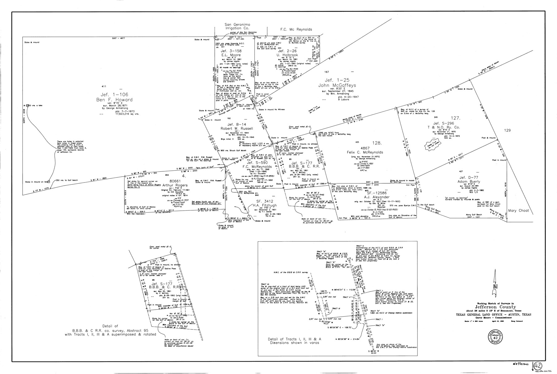
Jefferson County Working Sketch 42
-
Map/Doc
66586
-
Collection
General Map Collection
-
Object Dates
4/15/1996 (Creation Date)
-
People and Organizations
Doug Catenaci (Draftsman)
-
Counties
Jefferson
-
Subjects
Surveying Working Sketch
-
Height x Width
31.7 x 47.2 inches
80.5 x 119.9 cm
-
Scale
1" = 300 varas
Part of: General Map Collection
Grayson County Sketch File 12

Print $4.00
- Digital $50.00
Grayson County Sketch File 12
1853
Size 12.8 x 8.4 inches
Map/Doc 24478
Orange County Rolled Sketch 30

Print $20.00
- Digital $50.00
Orange County Rolled Sketch 30
1960
Size 32.4 x 34.9 inches
Map/Doc 9650
Crane County Working Sketch 29

Print $20.00
- Digital $50.00
Crane County Working Sketch 29
1976
Size 45.4 x 36.5 inches
Map/Doc 68306
Loving County Working Sketch 17

Print $20.00
- Digital $50.00
Loving County Working Sketch 17
1976
Size 43.5 x 38.2 inches
Map/Doc 70651
Henderson County Working Sketch 38

Print $20.00
- Digital $50.00
Henderson County Working Sketch 38
1982
Size 19.3 x 17.0 inches
Map/Doc 66171
McMullen County Sketch File 26

Print $20.00
- Digital $50.00
McMullen County Sketch File 26
1884
Size 14.7 x 19.8 inches
Map/Doc 12060
Flight Mission No. CGI-3N, Frame 134, Cameron County

Print $20.00
- Digital $50.00
Flight Mission No. CGI-3N, Frame 134, Cameron County
1954
Size 18.4 x 22.2 inches
Map/Doc 84607
Terrell County Rolled Sketch 42

Print $20.00
- Digital $50.00
Terrell County Rolled Sketch 42
1948
Size 27.4 x 38.6 inches
Map/Doc 7945
Map of Bell County

Print $40.00
- Digital $50.00
Map of Bell County
1896
Size 48.1 x 54.4 inches
Map/Doc 82066
Map of the United States and Texas designed to accompany Smith's Geography for Schools (Inset: Map of Mexico and Guatimala)

Print $20.00
- Digital $50.00
Map of the United States and Texas designed to accompany Smith's Geography for Schools (Inset: Map of Mexico and Guatimala)
1839
Size 11.8 x 19.1 inches
Map/Doc 93691
Flight Mission No. CRK-5P, Frame 125, Refugio County

Print $20.00
- Digital $50.00
Flight Mission No. CRK-5P, Frame 125, Refugio County
1956
Size 18.3 x 22.3 inches
Map/Doc 86928
Young County Sketch File 1

Print $8.00
- Digital $50.00
Young County Sketch File 1
1853
Size 7.9 x 9.7 inches
Map/Doc 40843
You may also like
Johnson County Sketch File 15

Print $2.00
- Digital $50.00
Johnson County Sketch File 15
1881
Size 8.1 x 7.3 inches
Map/Doc 28455
Stonewall County

Print $20.00
- Digital $50.00
Stonewall County
1902
Size 39.6 x 38.5 inches
Map/Doc 63049
Map of Austin's Little Colony

Print $20.00
- Digital $50.00
Map of Austin's Little Colony
Size 19.0 x 23.3 inches
Map/Doc 76007
Runnels County Sketch File 11

Print $8.00
Runnels County Sketch File 11
1883
Size 10.7 x 7.9 inches
Map/Doc 35452
Brewster County Working Sketch 24

Print $20.00
- Digital $50.00
Brewster County Working Sketch 24
1939
Size 17.2 x 42.1 inches
Map/Doc 67558

Grayson County Working Sketch 14

Print $20.00
- Digital $50.00
Grayson County Working Sketch 14
1952
Size 23.9 x 23.3 inches
Map/Doc 63253
Clay County Sketch File 1a

Print $25.00
- Digital $50.00
Clay County Sketch File 1a
1860
Size 8.8 x 8.2 inches
Map/Doc 18387
Edwards County Working Sketch 18

Print $20.00
- Digital $50.00
Edwards County Working Sketch 18
1931
Size 34.3 x 37.0 inches
Map/Doc 68894
Crockett County Sketch File 44

Print $8.00
- Digital $50.00
Crockett County Sketch File 44
1881
Size 12.8 x 8.8 inches
Map/Doc 19768
Flight Mission No. DAG-23K, Frame 144, Matagorda County

Print $20.00
- Digital $50.00
Flight Mission No. DAG-23K, Frame 144, Matagorda County
1953
Size 17.4 x 22.6 inches
Map/Doc 86492
