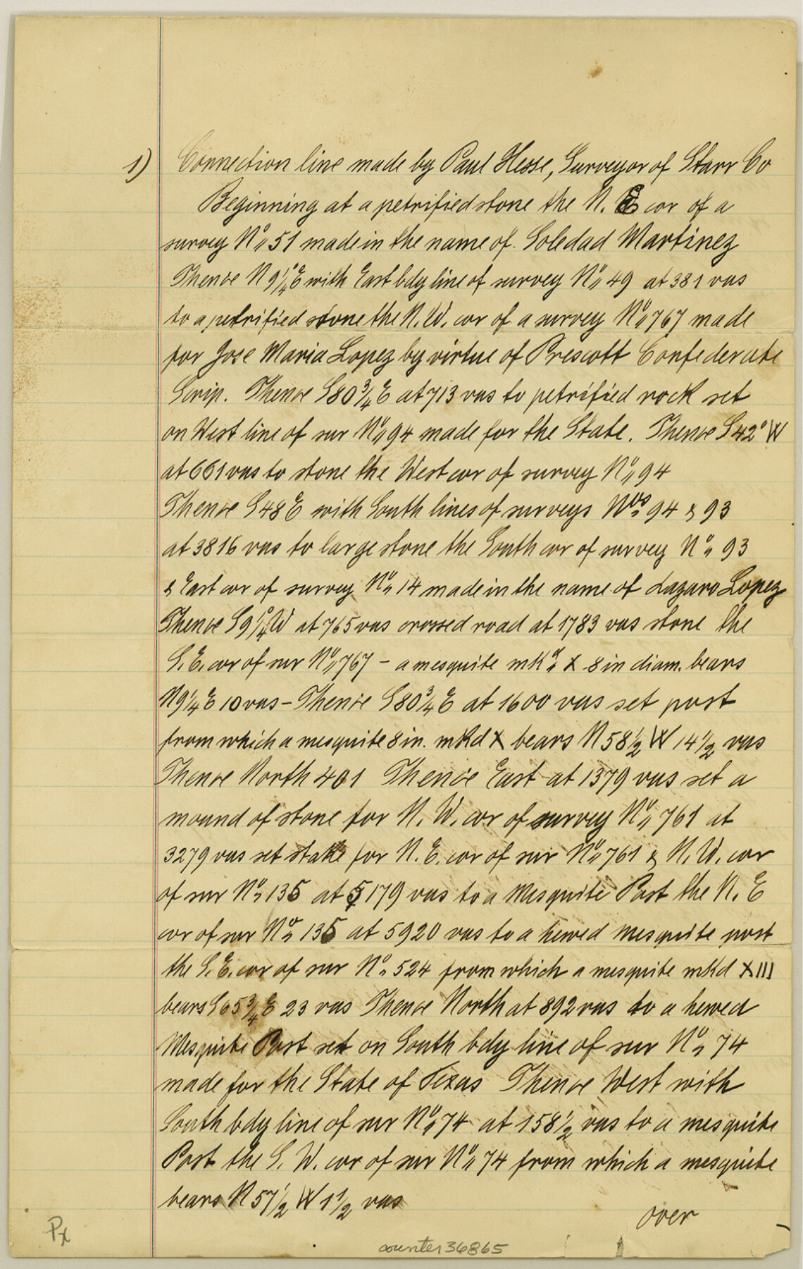
Starr County Sketch File 11
[Field notes of connecting lines and accompanying sketches of area northeast of Rio Grande City]
-
Map/Doc
36865
-
Collection
General Map Collection
-
Object Dates
11/28/1885 (Creation Date)
11/20/1885 (Survey Date)
-
People and Organizations
Paul Hesse (Surveyor/Engineer)
Philipp Hesse (Chainman/Field Personnel)
Eulalio Garcia (Chainman/Field Personnel)
-
Counties
Starr
-
Subjects
Surveying Sketch File
-
Height x Width
12.8 x 8.1 inches
32.5 x 20.6 cm
-
Medium
paper, manuscript
-
Features
El Junco Waterhole
Corpus Christi & Rio Grande City Road
Salt Lake Road
Part of: General Map Collection
Flight Mission No. DIX-6P, Frame 192, Aransas County

Print $20.00
- Digital $50.00
Flight Mission No. DIX-6P, Frame 192, Aransas County
1956
Size 19.0 x 22.8 inches
Map/Doc 83854
Montgomery County Sketch File 36

Print $40.00
- Digital $50.00
Montgomery County Sketch File 36
1953
Size 51.7 x 34.9 inches
Map/Doc 10551

Mills County Working Sketch 18

Print $20.00
- Digital $50.00
Mills County Working Sketch 18
1963
Size 23.2 x 37.0 inches
Map/Doc 71048
Coke County Rolled Sketch 21

Print $20.00
- Digital $50.00
Coke County Rolled Sketch 21
1954
Size 14.0 x 24.4 inches
Map/Doc 5522
Wilbarger County Sketch File 21

Print $4.00
- Digital $50.00
Wilbarger County Sketch File 21
1889
Size 11.1 x 8.6 inches
Map/Doc 40219
[Sketch for Mineral Application 33721 - 33725 Incl. - Padre and Mustang Island]
![2869, [Sketch for Mineral Application 33721 - 33725 Incl. - Padre and Mustang Island], General Map Collection](https://historictexasmaps.com/wmedia_w700/maps/2869.tif.jpg)
Print $20.00
- Digital $50.00
[Sketch for Mineral Application 33721 - 33725 Incl. - Padre and Mustang Island]
1942
Size 22.2 x 22.3 inches
Map/Doc 2869
Crane County Working Sketch 3

Print $20.00
- Digital $50.00
Crane County Working Sketch 3
1924
Size 36.2 x 34.4 inches
Map/Doc 68280
Aransas County NRC Article 33.136 Sketch 21

Print $138.00
Aransas County NRC Article 33.136 Sketch 21
2024
Map/Doc 97269
Flight Mission No. DQN-1K, Frame 32, Calhoun County

Print $20.00
- Digital $50.00
Flight Mission No. DQN-1K, Frame 32, Calhoun County
1953
Size 18.6 x 22.2 inches
Map/Doc 84137
Real County Working Sketch 15

Print $20.00
- Digital $50.00
Real County Working Sketch 15
1940
Size 17.7 x 22.3 inches
Map/Doc 71907
Map of Clay Co.

Print $40.00
- Digital $50.00
Map of Clay Co.
1896
Size 51.9 x 31.0 inches
Map/Doc 4785
You may also like
General Highway Map, Houston County, Texas

Print $20.00
General Highway Map, Houston County, Texas
1961
Size 24.6 x 18.3 inches
Map/Doc 79524
Map of Texas with Parts of the Adjoining States

Print $20.00
Map of Texas with Parts of the Adjoining States
1833
Size 29.3 x 23.3 inches
Map/Doc 79740
[John Durst's grant along the Trinity River]
![185, [John Durst's grant along the Trinity River], General Map Collection](https://historictexasmaps.com/wmedia_w700/maps/185.tif.jpg)
Print $2.00
- Digital $50.00
[John Durst's grant along the Trinity River]
Size 12.3 x 8.2 inches
Map/Doc 185
Index to Field Notes, Plats: Spanish Archives

Index to Field Notes, Plats: Spanish Archives
1981
Map/Doc 94531
Bandera County Boundary File 5

Print $44.00
- Digital $50.00
Bandera County Boundary File 5
Size 14.2 x 8.7 inches
Map/Doc 50299
Working Sketch in Mitchell, Sterling, and Coke Co's.

Print $20.00
- Digital $50.00
Working Sketch in Mitchell, Sterling, and Coke Co's.
1925
Size 34.2 x 30.7 inches
Map/Doc 91840
Val Verde County Rolled Sketch 22

Print $40.00
- Digital $50.00
Val Verde County Rolled Sketch 22
1892
Size 51.8 x 38.7 inches
Map/Doc 10071
Outer Continental Shelf Leasing Maps (Texas Offshore Operations)

Print $20.00
- Digital $50.00
Outer Continental Shelf Leasing Maps (Texas Offshore Operations)
1954
Size 20.3 x 15.5 inches
Map/Doc 75839
Brooks County Sketch File 3

Print $40.00
- Digital $50.00
Brooks County Sketch File 3
Size 21.5 x 19.0 inches
Map/Doc 11016
[Blocks 341, G-5, G-12, TCRRCo.]
![60298, [Blocks 341, G-5, G-12, TCRRCo.], General Map Collection](https://historictexasmaps.com/wmedia_w700/maps/60298-1.tif.jpg)
Print $20.00
- Digital $50.00
[Blocks 341, G-5, G-12, TCRRCo.]
1954
Size 15.1 x 26.1 inches
Map/Doc 60298
Falls County Sketch File 24

Print $4.00
- Digital $50.00
Falls County Sketch File 24
1859
Size 13.1 x 8.2 inches
Map/Doc 22428
Webb County Sketch File 55

Print $20.00
- Digital $50.00
Webb County Sketch File 55
1940
Size 20.6 x 12.6 inches
Map/Doc 12650