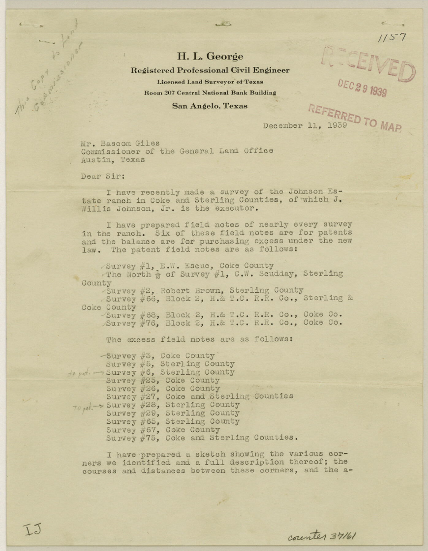
Sterling County Sketch File 18
[Letter regarding Block 2, H. & T. C.]
-
Map/Doc
37161
-
Collection
General Map Collection
-
Object Dates
1939/12/11 (Creation Date)
1939/12/29 (File Date)
1939/12/11 (Correspondence Date)
-
People and Organizations
H.L. George (Surveyor/Engineer)
Stephen Turner (Surveyor/Engineer)
George Williams (Surveyor/Engineer)
-
Counties
Sterling Coke
-
Subjects
Surveying Sketch File
-
Height x Width
11.2 x 8.7 inches
28.4 x 22.1 cm
-
Medium
paper, print
Part of: General Map Collection
Karnes County Rolled Sketch 4

Print $20.00
- Digital $50.00
Karnes County Rolled Sketch 4
1961
Size 33.4 x 37.7 inches
Map/Doc 9667
Jack County Working Sketch 19

Print $20.00
- Digital $50.00
Jack County Working Sketch 19
1989
Size 21.5 x 29.4 inches
Map/Doc 66445
Lamb County Working Sketch 3

Print $20.00
- Digital $50.00
Lamb County Working Sketch 3
1962
Size 32.1 x 37.7 inches
Map/Doc 70276
Flight Mission No. DQO-1K, Frame 155, Galveston County

Print $20.00
- Digital $50.00
Flight Mission No. DQO-1K, Frame 155, Galveston County
1952
Size 18.9 x 22.5 inches
Map/Doc 85008
Plan of the City of Calhoun

Print $40.00
- Digital $50.00
Plan of the City of Calhoun
1839
Size 49.7 x 58.9 inches
Map/Doc 2175
Webb County Rolled Sketch 7

Print $20.00
- Digital $50.00
Webb County Rolled Sketch 7
Size 29.1 x 43.7 inches
Map/Doc 8173
Go Turnpike! Dallas-Fort Worth Turnpike (Recto)

Go Turnpike! Dallas-Fort Worth Turnpike (Recto)
1963
Size 11.2 x 17.2 inches
Map/Doc 94177
Liberty County Working Sketch 18

Print $20.00
- Digital $50.00
Liberty County Working Sketch 18
1939
Size 20.5 x 20.4 inches
Map/Doc 70477
Deaf Smith County Working Sketch 3

Print $40.00
- Digital $50.00
Deaf Smith County Working Sketch 3
1951
Size 61.4 x 22.3 inches
Map/Doc 68643
Tyler County Sketch File 14

Print $4.00
- Digital $50.00
Tyler County Sketch File 14
1857
Size 8.3 x 10.1 inches
Map/Doc 38656

Kimble County Boundary File 4

Print $26.00
- Digital $50.00
Kimble County Boundary File 4
Size 7.5 x 7.3 inches
Map/Doc 64868
You may also like
The Continent and Islands of the West Indies

Print $20.00
The Continent and Islands of the West Indies
1804
Size 22.8 x 26.0 inches
Map/Doc 79318
Nueces County Working Sketch 3

Print $20.00
- Digital $50.00
Nueces County Working Sketch 3
1972
Size 38.9 x 45.0 inches
Map/Doc 71305
Flight Mission No. BQY-4M, Frame 126, Harris County

Print $20.00
- Digital $50.00
Flight Mission No. BQY-4M, Frame 126, Harris County
1953
Size 18.5 x 22.2 inches
Map/Doc 85295
Aransas County Rolled Sketch 24

Print $20.00
- Digital $50.00
Aransas County Rolled Sketch 24
Size 22.5 x 34.8 inches
Map/Doc 77495
[T. & N. O. R.R. Jefferson Co. North]
![64055, [T. & N. O. R.R. Jefferson Co. North], General Map Collection](https://historictexasmaps.com/wmedia_w700/maps/64055.tif.jpg)
Print $20.00
- Digital $50.00
[T. & N. O. R.R. Jefferson Co. North]
Size 13.4 x 33.4 inches
Map/Doc 64055
Right of Way and Track Map Houston & Texas Central R.R. operated by the T. & N.O. R.R. Co., Austin Branch

Print $40.00
- Digital $50.00
Right of Way and Track Map Houston & Texas Central R.R. operated by the T. & N.O. R.R. Co., Austin Branch
1918
Size 25.8 x 57.8 inches
Map/Doc 64558
Young County Sketch File 20

Print $20.00
- Digital $50.00
Young County Sketch File 20
1922
Size 27.4 x 23.9 inches
Map/Doc 12714
Travis County Rolled Sketch 38

Print $20.00
- Digital $50.00
Travis County Rolled Sketch 38
Size 31.9 x 30.3 inches
Map/Doc 8038
Navasota River, Springfield Sheet

Print $20.00
- Digital $50.00
Navasota River, Springfield Sheet
1934
Size 41.5 x 37.8 inches
Map/Doc 65074

Angelina County Working Sketch 2

Print $20.00
- Digital $50.00
Angelina County Working Sketch 2
1899
Size 18.3 x 23.4 inches
Map/Doc 67082
Crockett County Rolled Sketch E

Print $20.00
- Digital $50.00
Crockett County Rolled Sketch E
1907
Size 26.2 x 27.7 inches
Map/Doc 5636