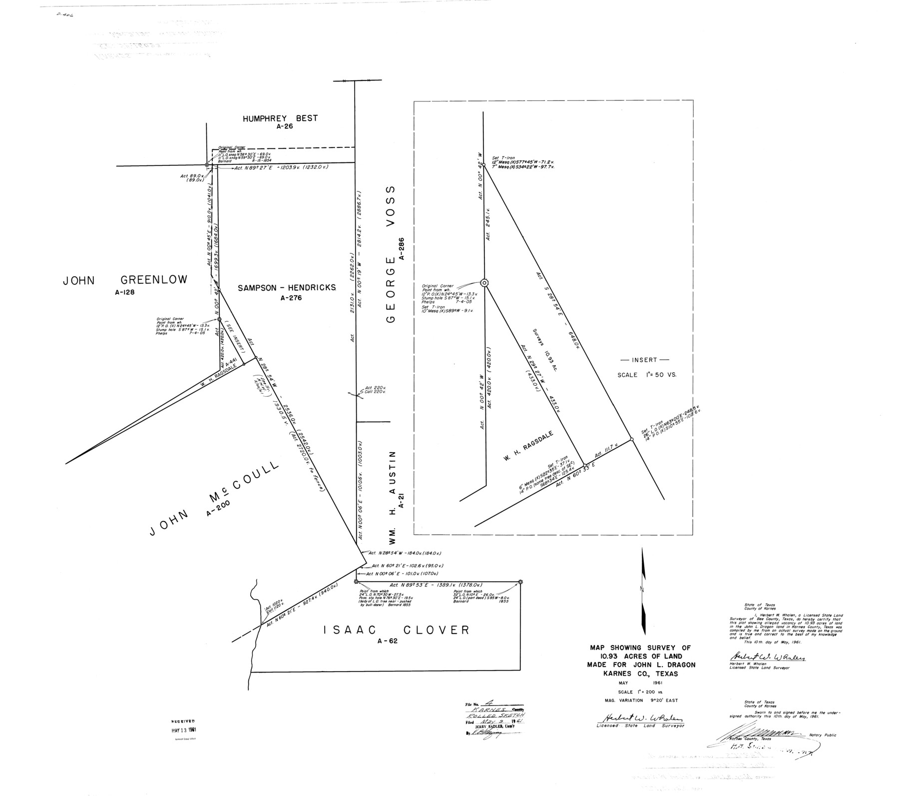
Karnes County Rolled Sketch 4
Map showing survey of 10.93 acres of land made for John L. Dragon, Karnes Co., Texas
-
Map/Doc
9667
-
Collection
General Map Collection
-
Object Dates
1961/5/10 (Creation Date)
1961/5/15 (File Date)
-
People and Organizations
Herbert W. Whalen (Surveyor/Engineer)
-
Counties
Karnes
-
Subjects
Surveying Rolled Sketch
-
Height x Width
33.4 x 37.7 inches
84.8 x 95.8 cm
-
Scale
1" = 200 varas
Part of: General Map Collection
[Surveys in the Travis District along Onion Creek and the Pedernales River]
![40, [Surveys in the Travis District along Onion Creek and the Pedernales River], General Map Collection](https://historictexasmaps.com/wmedia_w700/maps/40.tif.jpg)
Print $20.00
- Digital $50.00
[Surveys in the Travis District along Onion Creek and the Pedernales River]
1841
Size 14.0 x 15.8 inches
Map/Doc 40
Webb County Sketch File 20

Print $4.00
- Digital $50.00
Webb County Sketch File 20
Size 8.8 x 14.4 inches
Map/Doc 39827
Flight Mission No. CUG-3P, Frame 164, Kleberg County

Print $20.00
- Digital $50.00
Flight Mission No. CUG-3P, Frame 164, Kleberg County
1956
Size 18.5 x 22.2 inches
Map/Doc 86284
Old Miscellaneous File 22

Print $18.00
- Digital $50.00
Old Miscellaneous File 22
1915
Size 14.2 x 8.7 inches
Map/Doc 75591
Hamilton County Working Sketch 13

Print $40.00
- Digital $50.00
Hamilton County Working Sketch 13
1949
Size 43.5 x 57.0 inches
Map/Doc 63351
Montgomery County Rolled Sketch 42

Print $20.00
- Digital $50.00
Montgomery County Rolled Sketch 42
1939
Size 13.9 x 20.2 inches
Map/Doc 6820
Presidio County Working Sketch 68

Print $20.00
- Digital $50.00
Presidio County Working Sketch 68
1960
Size 45.8 x 33.1 inches
Map/Doc 71745
Reagan County Sketch File 4

Print $20.00
- Digital $50.00
Reagan County Sketch File 4
Size 20.8 x 29.8 inches
Map/Doc 12214
Sketch of surveys made by Erath and Green in August 1846 on the waters of the Bosque River

Print $2.00
- Digital $50.00
Sketch of surveys made by Erath and Green in August 1846 on the waters of the Bosque River
1846
Size 10.6 x 7.8 inches
Map/Doc 303
Val Verde County Sketch File 28

Print $20.00
- Digital $50.00
Val Verde County Sketch File 28
Size 29.9 x 25.1 inches
Map/Doc 12573
Andrews County Working Sketch 21

Print $40.00
- Digital $50.00
Andrews County Working Sketch 21
1979
Size 38.7 x 48.4 inches
Map/Doc 67067
Nueces County Working Sketch 7

Print $40.00
- Digital $50.00
Nueces County Working Sketch 7
1972
Size 26.9 x 72.6 inches
Map/Doc 71309
You may also like
Gaines County Working Sketch 16

Print $20.00
- Digital $50.00
Gaines County Working Sketch 16
1959
Size 42.4 x 37.3 inches
Map/Doc 69316
Shelby County Sketch File 12

Print $4.00
- Digital $50.00
Shelby County Sketch File 12
Size 8.2 x 10.3 inches
Map/Doc 36619
Flight Mission No. BRE-1P, Frame 55, Nueces County

Print $20.00
- Digital $50.00
Flight Mission No. BRE-1P, Frame 55, Nueces County
1956
Size 18.3 x 22.2 inches
Map/Doc 86644
Flight Mission No. CRC-2R, Frame 186, Chambers County

Print $20.00
- Digital $50.00
Flight Mission No. CRC-2R, Frame 186, Chambers County
1956
Size 18.7 x 22.4 inches
Map/Doc 84764
Dickens County Boundary File 3

Print $28.00
- Digital $50.00
Dickens County Boundary File 3
Size 14.1 x 8.8 inches
Map/Doc 52541
Montgomery County Working Sketch 40

Print $20.00
- Digital $50.00
Montgomery County Working Sketch 40
1954
Size 18.1 x 23.3 inches
Map/Doc 71147
Map of the Texas & Pacific Railway "Gould System" Lines and connections

Print $20.00
- Digital $50.00
Map of the Texas & Pacific Railway "Gould System" Lines and connections
1906
Size 17.7 x 36.6 inches
Map/Doc 95769
Brewster County Rolled Sketch 49

Print $20.00
- Digital $50.00
Brewster County Rolled Sketch 49
1930
Size 35.1 x 47.4 inches
Map/Doc 8478
Township No. 1 South Range No. 25 West of the Indian Meridian

Print $20.00
- Digital $50.00
Township No. 1 South Range No. 25 West of the Indian Meridian
1875
Size 19.2 x 24.3 inches
Map/Doc 75248
Southern Part of Laguna Madre

Print $20.00
- Digital $50.00
Southern Part of Laguna Madre
1985
Size 45.3 x 36.6 inches
Map/Doc 73547
Harris County Rolled Sketch P4

Print $20.00
- Digital $50.00
Harris County Rolled Sketch P4
1920
Size 12.1 x 34.6 inches
Map/Doc 6143
Map of Fannin County

Print $20.00
- Digital $50.00
Map of Fannin County
1866
Size 21.9 x 18.1 inches
Map/Doc 3534