Starr County Sketch File 35
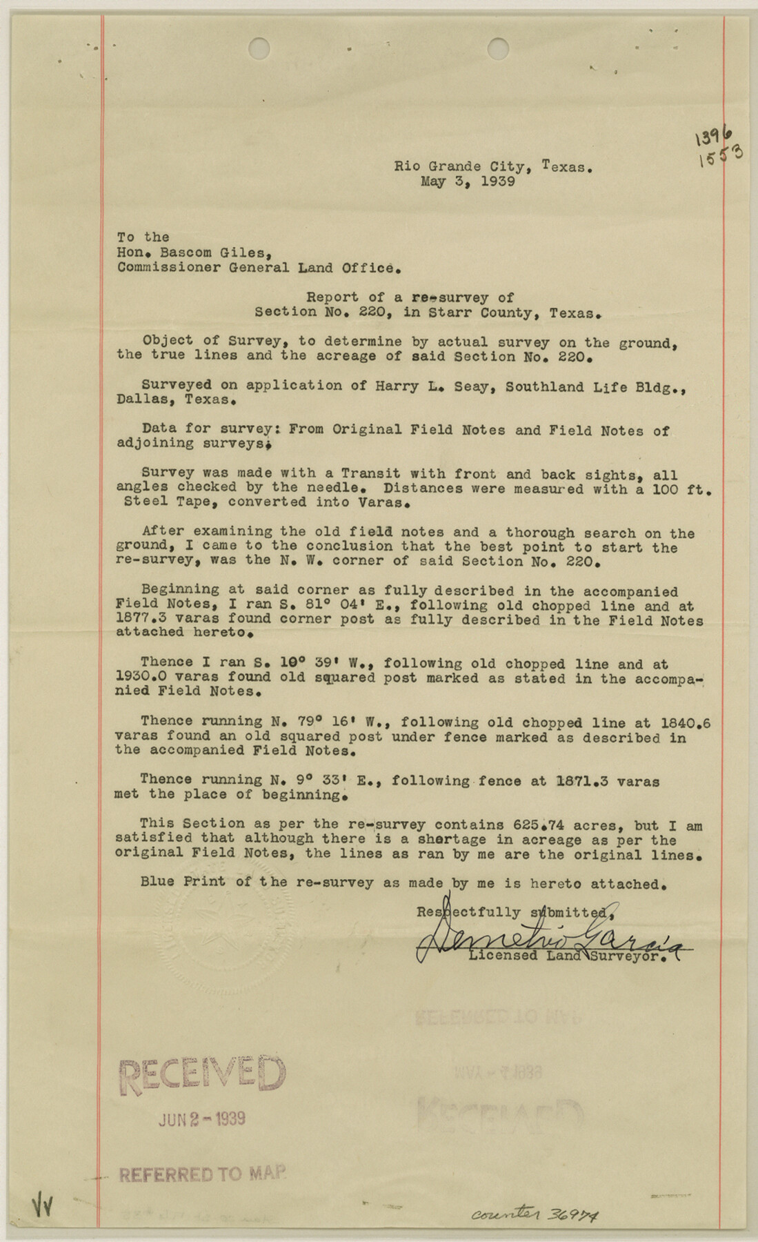
[Report and sketch of a resurvey of section 220 northeast from the county seat]
-
Map/Doc
36974
-
Collection
General Map Collection
-
Object Dates
1939 (Creation Date)
6/5/1939 (File Date)
-
People and Organizations
Demetrio Garcia (Surveyor/Engineer)
-
Counties
Starr
-
Subjects
Surveying Sketch File
-
Height x Width
14.3 x 8.8 inches
36.3 x 22.4 cm
-
Medium
multi-page, multi-format
-
Scale
1" = 200 varas
Part of: General Map Collection
Texas Gulf Coast from Sabine River to Rio Grande As Subdivided for Mineral Development - Obsolete

Print $40.00
- Digital $50.00
Texas Gulf Coast from Sabine River to Rio Grande As Subdivided for Mineral Development - Obsolete
1948
Size 42.0 x 70.8 inches
Map/Doc 2946
El Paso County Working Sketch 6

Print $20.00
- Digital $50.00
El Paso County Working Sketch 6
1928
Size 25.4 x 16.7 inches
Map/Doc 69028
Gulf, Texas & Western Railway

Print $40.00
- Digital $50.00
Gulf, Texas & Western Railway
1909
Size 18.7 x 103.5 inches
Map/Doc 64431
Right of Way and Track Map, Texas & New Orleans R.R. operated by the T. & N. O. R.R. Co., Rusk Branch

Print $40.00
- Digital $50.00
Right of Way and Track Map, Texas & New Orleans R.R. operated by the T. & N. O. R.R. Co., Rusk Branch
1918
Size 24.7 x 56.2 inches
Map/Doc 64243
La Salle County Working Sketch 39

Print $20.00
- Digital $50.00
La Salle County Working Sketch 39
1963
Size 30.4 x 25.4 inches
Map/Doc 70340
Freestone County Sketch File 12

Print $6.00
- Digital $50.00
Freestone County Sketch File 12
Size 8.2 x 6.3 inches
Map/Doc 23060
Bee County Sketch File 22

Print $8.00
- Digital $50.00
Bee County Sketch File 22
1878
Size 10.0 x 8.0 inches
Map/Doc 14314
Township 6 North Range 14 West, North Western District, Louisiana

Print $20.00
- Digital $50.00
Township 6 North Range 14 West, North Western District, Louisiana
1841
Size 19.5 x 24.7 inches
Map/Doc 65863
Cass County Working Sketch 7

Print $20.00
- Digital $50.00
Cass County Working Sketch 7
1937
Size 21.9 x 28.9 inches
Map/Doc 67910
Menard County Working Sketch 5

Print $20.00
- Digital $50.00
Menard County Working Sketch 5
1921
Size 17.2 x 22.3 inches
Map/Doc 70952
Matagorda County NRC Article 33.136 Sketch 13

Print $22.00
- Digital $50.00
Matagorda County NRC Article 33.136 Sketch 13
Size 24.2 x 36.0 inches
Map/Doc 95720
Fractional Township No. 10 South Range No. 9 East of the Indian Meridian, Indian Territory

Print $20.00
- Digital $50.00
Fractional Township No. 10 South Range No. 9 East of the Indian Meridian, Indian Territory
1898
Size 19.3 x 24.4 inches
Map/Doc 75217
You may also like
Houston County Working Sketch 29

Print $20.00
- Digital $50.00
Houston County Working Sketch 29
1990
Size 23.4 x 23.1 inches
Map/Doc 66259
Brooks County Working Sketch 20

Print $20.00
- Digital $50.00
Brooks County Working Sketch 20
Size 16.5 x 21.6 inches
Map/Doc 78198
Angelina County Working Sketch 10

Print $20.00
- Digital $50.00
Angelina County Working Sketch 10
1934
Size 35.0 x 36.9 inches
Map/Doc 67091
Sketch showing county lines of Lynn, Garza, Borden, Scurry

Print $40.00
- Digital $50.00
Sketch showing county lines of Lynn, Garza, Borden, Scurry
1961
Size 23.9 x 79.9 inches
Map/Doc 1719
Crane County Sketch File 3a

Print $20.00
- Digital $50.00
Crane County Sketch File 3a
Size 20.8 x 13.0 inches
Map/Doc 11205
Frio County Rolled Sketch 11

Print $20.00
- Digital $50.00
Frio County Rolled Sketch 11
1948
Size 44.4 x 43.8 inches
Map/Doc 8903
[Surveying Sketch of Northern Portion of Hutchinson County]
![5065, [Surveying Sketch of Northern Portion of Hutchinson County], Maddox Collection](https://historictexasmaps.com/wmedia_w700/maps/5065.tif.jpg)
Print $20.00
- Digital $50.00
[Surveying Sketch of Northern Portion of Hutchinson County]
1890
Size 26.5 x 42.5 inches
Map/Doc 5065
Matagorda County Working Sketch Graphic Index, Sheet 2 (Sketches 17 to Most Recent)

Print $40.00
- Digital $50.00
Matagorda County Working Sketch Graphic Index, Sheet 2 (Sketches 17 to Most Recent)
1920
Size 40.1 x 48.6 inches
Map/Doc 76634
Denton County Boundary File 4 and 4a and 4b and 4c

Print $168.00
- Digital $50.00
Denton County Boundary File 4 and 4a and 4b and 4c
Size 11.1 x 8.6 inches
Map/Doc 52448
Fayette County

Print $40.00
- Digital $50.00
Fayette County
1978
Size 43.6 x 56.1 inches
Map/Doc 95496
Webb County Rolled Sketch 63

Print $20.00
- Digital $50.00
Webb County Rolled Sketch 63
1948
Size 39.4 x 37.0 inches
Map/Doc 10129
Lynn County Boundary File 7a

Print $8.00
- Digital $50.00
Lynn County Boundary File 7a
Size 14.3 x 8.8 inches
Map/Doc 56647