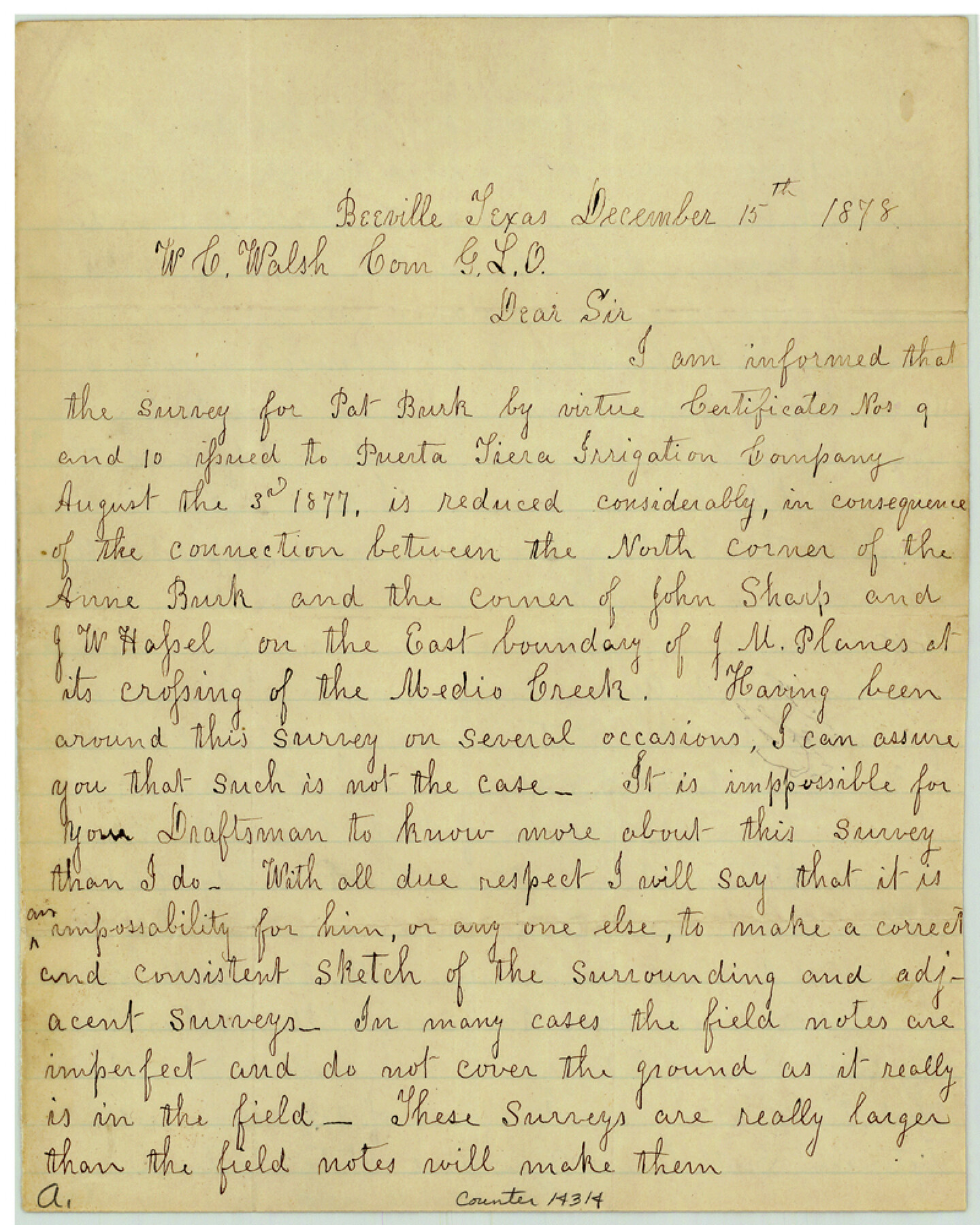
Bee County Sketch File 22
[Surveyor's statement concerning surveys southeast of Beeville]
-
Map/Doc
14314
-
Collection
General Map Collection
-
Object Dates
1878/12/15 (Creation Date)
-
People and Organizations
J.F. Fenner (Surveyor/Engineer)
-
Counties
Bee
-
Subjects
Surveying Sketch File
-
Height x Width
10.0 x 8.0 inches
25.4 x 20.3 cm
-
Medium
paper, manuscript
-
Features
Medio Creek
Poista Creek
Blanco Creek
Part of: General Map Collection
[Map of Henderson County]
![76767, [Map of Henderson County], General Map Collection](https://historictexasmaps.com/wmedia_w700/maps/76767.tif.jpg)
Print $20.00
- Digital $50.00
[Map of Henderson County]
1854
Size 29.7 x 22.0 inches
Map/Doc 76767
Rusk County Working Sketch 38

Print $20.00
- Digital $50.00
Rusk County Working Sketch 38
2008
Size 16.3 x 23.3 inches
Map/Doc 88815
Ector County Boundary File 1

Print $10.00
- Digital $50.00
Ector County Boundary File 1
Size 13.3 x 8.4 inches
Map/Doc 52829
Controlled Mosaic by Jack Amman Photogrammetric Engineers, Inc - Sheet 42

Print $20.00
- Digital $50.00
Controlled Mosaic by Jack Amman Photogrammetric Engineers, Inc - Sheet 42
1954
Size 20.0 x 24.0 inches
Map/Doc 83501
Amistad International Reservoir on Rio Grande Key Sheet

Print $20.00
- Digital $50.00
Amistad International Reservoir on Rio Grande Key Sheet
1960
Size 13.0 x 32.4 inches
Map/Doc 73345
Flight Mission No. DCL-6C, Frame 128, Kenedy County

Print $20.00
- Digital $50.00
Flight Mission No. DCL-6C, Frame 128, Kenedy County
1943
Size 18.6 x 22.3 inches
Map/Doc 85958
Hardin County Sketch File 24a

Print $8.00
- Digital $50.00
Hardin County Sketch File 24a
1868
Size 5.8 x 7.9 inches
Map/Doc 25142
Webb County Working Sketch 82

Print $40.00
- Digital $50.00
Webb County Working Sketch 82
1979
Size 32.9 x 62.9 inches
Map/Doc 72449
Flight Mission No. DQN-7K, Frame 39, Calhoun County

Print $20.00
- Digital $50.00
Flight Mission No. DQN-7K, Frame 39, Calhoun County
1953
Size 19.0 x 22.5 inches
Map/Doc 84477
Harris County Sketch File 62

Print $14.00
- Digital $50.00
Harris County Sketch File 62
1930
Size 11.4 x 8.7 inches
Map/Doc 25486
Map of Wilson County

Print $20.00
- Digital $50.00
Map of Wilson County
1840
Size 24.4 x 21.0 inches
Map/Doc 4154
Stephens County Sketch File 21

Print $20.00
- Digital $50.00
Stephens County Sketch File 21
Size 25.3 x 19.6 inches
Map/Doc 12351
You may also like

Real County Working Sketch 74

Print $20.00
- Digital $50.00
Real County Working Sketch 74
1979
Size 17.1 x 23.5 inches
Map/Doc 71966
Eastland County Working Sketch 64

Print $40.00
- Digital $50.00
Eastland County Working Sketch 64
1983
Size 43.3 x 68.4 inches
Map/Doc 88891
Frio County Boundary File 31

Print $19.00
- Digital $50.00
Frio County Boundary File 31
Size 9.3 x 4.4 inches
Map/Doc 53609
Map of N. W. Portion Blk G. Gaines Co.

Print $20.00
- Digital $50.00
Map of N. W. Portion Blk G. Gaines Co.
1914
Size 37.4 x 26.7 inches
Map/Doc 90867
Fort Bend County Sketch File 4a

Print $40.00
- Digital $50.00
Fort Bend County Sketch File 4a
1887
Size 15.8 x 12.3 inches
Map/Doc 22887
Lebanon Quadrangle

Print $20.00
- Digital $50.00
Lebanon Quadrangle
1999
Size 35.4 x 23.4 inches
Map/Doc 97360
Flight Mission No. DQN-2K, Frame 76, Calhoun County

Print $20.00
- Digital $50.00
Flight Mission No. DQN-2K, Frame 76, Calhoun County
1953
Size 18.8 x 22.3 inches
Map/Doc 84268
Hansford County Working Sketch 9

Print $20.00
- Digital $50.00
Hansford County Working Sketch 9
1984
Size 31.5 x 38.2 inches
Map/Doc 63381
Map of Goliad County

Print $20.00
- Digital $50.00
Map of Goliad County
1853
Size 30.7 x 24.2 inches
Map/Doc 3585
Zapata County Sketch File 17

Print $32.00
- Digital $50.00
Zapata County Sketch File 17
1959
Size 14.4 x 8.9 inches
Map/Doc 40960
Galveston County Sketch File 66

Print $116.00
- Digital $50.00
Galveston County Sketch File 66
Size 5.0 x 10.0 inches
Map/Doc 23751