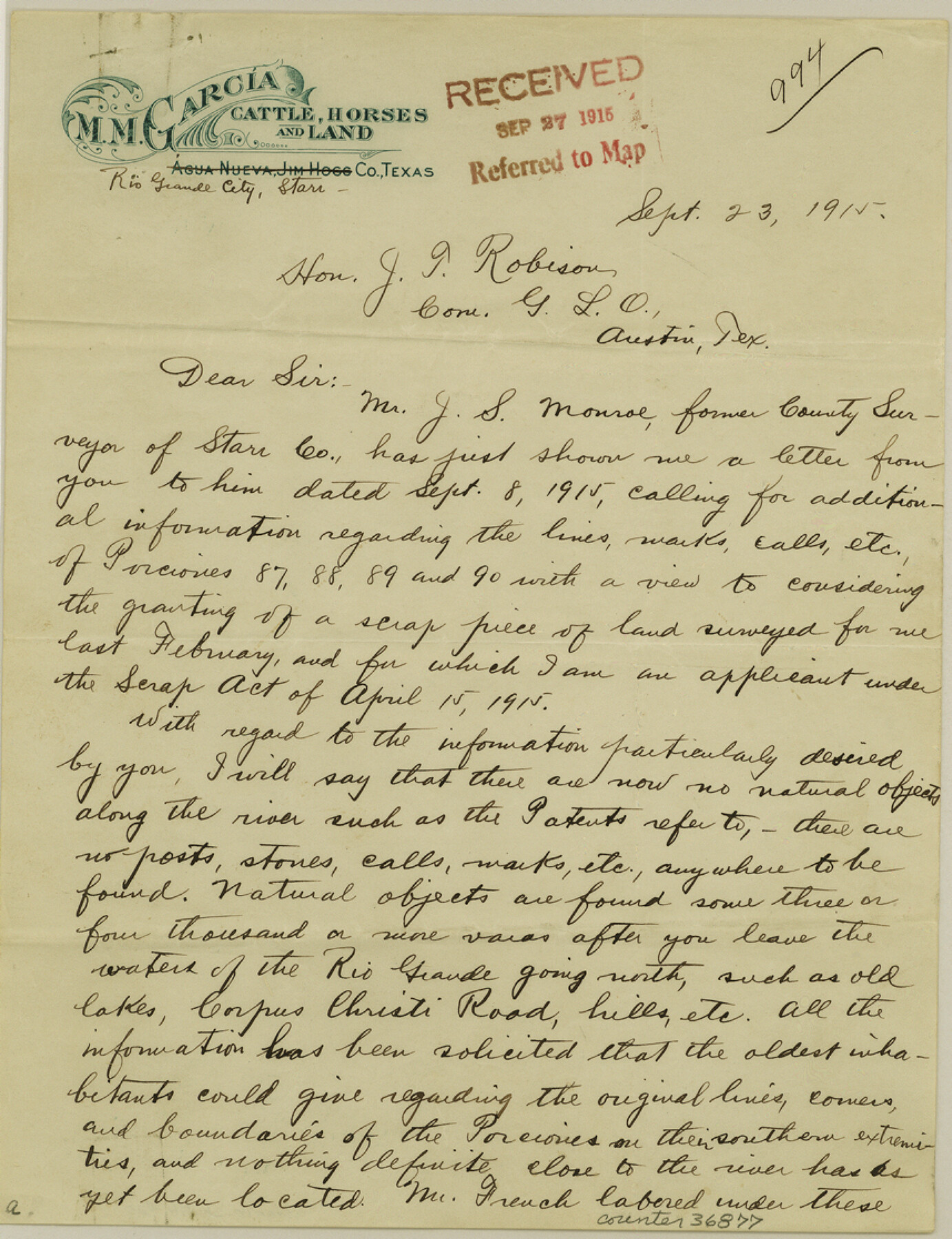
Starr County Sketch File 20
[Letter regarding application for vacancies north of porciones 87-92 east of Rio Grande City]
-
Map/Doc
36877
-
Collection
General Map Collection
-
Object Dates
9/23/1915 (Creation Date)
9/27/1915 (File Date)
-
People and Organizations
M.M. Garcia (Author)
-
Counties
Starr
-
Subjects
Surveying Sketch File
-
Height x Width
11.2 x 8.6 inches
28.5 x 21.8 cm
-
Medium
paper, manuscript
-
Features
Rio Grande
Corpus Christi Road
Part of: General Map Collection
Nolan County Working Sketch 4

Print $20.00
- Digital $50.00
Nolan County Working Sketch 4
1948
Size 21.6 x 28.9 inches
Map/Doc 71295
The Absolem C. De La Plain League and Labor of Land

Print $20.00
- Digital $50.00
The Absolem C. De La Plain League and Labor of Land
2013
Size 30.0 x 24.0 inches
Map/Doc 93425
Map of the country scouted by Colonels McKenzie and Shafter, Capt. R.P. Wilson and others in the years, 1874 & 1875

Print $20.00
- Digital $50.00
Map of the country scouted by Colonels McKenzie and Shafter, Capt. R.P. Wilson and others in the years, 1874 & 1875
1876
Size 43.0 x 31.8 inches
Map/Doc 62972
Kaufman County Rolled Sketch 1

Print $20.00
- Digital $50.00
Kaufman County Rolled Sketch 1
1951
Size 26.4 x 34.8 inches
Map/Doc 6456
Duval County Rolled Sketch 17

Print $20.00
- Digital $50.00
Duval County Rolled Sketch 17
1940
Size 18.9 x 17.9 inches
Map/Doc 5738
Flight Mission No. DQN-6K, Frame 4, Calhoun County

Print $20.00
- Digital $50.00
Flight Mission No. DQN-6K, Frame 4, Calhoun County
1953
Size 18.4 x 22.1 inches
Map/Doc 84426
Oldham County Boundary File 1

Print $6.00
- Digital $50.00
Oldham County Boundary File 1
Size 8.8 x 7.2 inches
Map/Doc 57731
Harris County Sketch File 69

Print $12.00
- Digital $50.00
Harris County Sketch File 69
1938
Size 11.5 x 8.8 inches
Map/Doc 25512
Panola County Working Sketch Graphic Index

Print $20.00
- Digital $50.00
Panola County Working Sketch Graphic Index
1947
Map/Doc 76660
Flight Mission No. BRE-2P, Frame 110, Nueces County

Print $20.00
- Digital $50.00
Flight Mission No. BRE-2P, Frame 110, Nueces County
1956
Size 18.6 x 22.6 inches
Map/Doc 86796
Angelina County Working Sketch 47

Print $20.00
- Digital $50.00
Angelina County Working Sketch 47
1976
Size 36.9 x 41.9 inches
Map/Doc 67130
Tyler County Sketch File 20

Print $6.00
- Digital $50.00
Tyler County Sketch File 20
1851
Size 6.9 x 5.8 inches
Map/Doc 38674
You may also like
Flight Mission No. BRA-6M, Frame 150, Jefferson County

Print $20.00
- Digital $50.00
Flight Mission No. BRA-6M, Frame 150, Jefferson County
1953
Size 18.5 x 22.4 inches
Map/Doc 85451
Val Verde County Sketch File 43

Print $20.00
- Digital $50.00
Val Verde County Sketch File 43
1938
Size 24.8 x 32.3 inches
Map/Doc 12585
Madison County Working Sketch Graphic Index

Print $20.00
- Digital $50.00
Madison County Working Sketch Graphic Index
1922
Size 29.4 x 47.6 inches
Map/Doc 76628
Map of Cameron County

Print $20.00
- Digital $50.00
Map of Cameron County
1873
Size 42.9 x 24.3 inches
Map/Doc 66744
Map of subdivision of submerged land in the Gulf of Mexico fronting on Matagorda Island and Peninsula

Print $40.00
- Digital $50.00
Map of subdivision of submerged land in the Gulf of Mexico fronting on Matagorda Island and Peninsula
1940
Size 21.5 x 70.0 inches
Map/Doc 2931
Flight Mission No. DAG-24K, Frame 159, Matagorda County

Print $20.00
- Digital $50.00
Flight Mission No. DAG-24K, Frame 159, Matagorda County
1953
Size 17.2 x 19.1 inches
Map/Doc 86573
Sutton County Sketch File 60

Print $20.00
- Digital $50.00
Sutton County Sketch File 60
Size 34.6 x 43.9 inches
Map/Doc 10378
[Shelby District]
![69740, [Shelby District], General Map Collection](https://historictexasmaps.com/wmedia_w700/maps/69740.tif.jpg)
Print $2.00
- Digital $50.00
[Shelby District]
1845
Size 6.9 x 7.6 inches
Map/Doc 69740
Working Sketch in Crane County

Print $20.00
- Digital $50.00
Working Sketch in Crane County
1929
Size 29.2 x 34.3 inches
Map/Doc 90467
Hays County Sketch File A

Print $6.00
- Digital $50.00
Hays County Sketch File A
1881
Size 10.8 x 8.4 inches
Map/Doc 26186
Runnels County Working Sketch 9

Print $40.00
- Digital $50.00
Runnels County Working Sketch 9
1948
Size 48.9 x 27.9 inches
Map/Doc 63605
Galveston County NRC Article 33.136 Sketch 42

Print $26.00
- Digital $50.00
Galveston County NRC Article 33.136 Sketch 42
2006
Size 22.1 x 33.7 inches
Map/Doc 83070