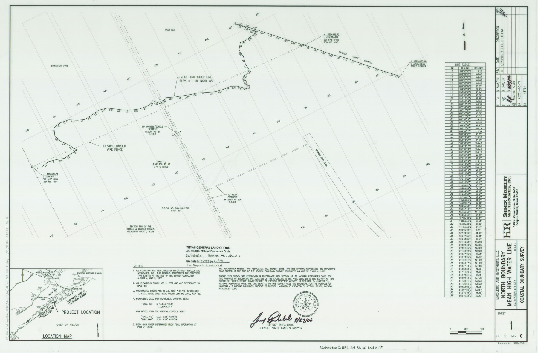
Galveston County NRC Article 33.136 Sketch 42
A Survey of Mean High Water Line South of Starvation Cove
-
Map/Doc
83070
-
Collection
General Map Collection
-
Object Dates
2006/9/29 (Creation Date)
2006/10/9 (File Date)
-
People and Organizations
Shiner Moseley & Associates, Inc. (Publisher)
Shiner Moseley & Associates, Inc. (Printer)
George Rubalcaba (Surveyor/Engineer)
-
Counties
Galveston
-
Subjects
Surveying CBS
-
Height x Width
22.1 x 33.7 inches
56.1 x 85.6 cm
-
Medium
multi-page, multi-format
-
Comments
Survey located about 10 1/2 miles South 64 degrees West of Galveston, Texas.
Part of: General Map Collection
Flight Mission No. CRC-3R, Frame 49, Chambers County

Print $20.00
- Digital $50.00
Flight Mission No. CRC-3R, Frame 49, Chambers County
1956
Size 18.6 x 22.3 inches
Map/Doc 84822
Pecos County Working Sketch 115

Print $40.00
- Digital $50.00
Pecos County Working Sketch 115
1973
Size 54.6 x 31.8 inches
Map/Doc 71588
Map of Bexar County

Print $40.00
- Digital $50.00
Map of Bexar County
1845
Size 90.6 x 81.0 inches
Map/Doc 82242
Reagan County Sketch File 25

Print $20.00
- Digital $50.00
Reagan County Sketch File 25
1941
Size 18.1 x 23.9 inches
Map/Doc 12222
Brooks County Rolled Sketch 16

Print $20.00
- Digital $50.00
Brooks County Rolled Sketch 16
1941
Size 18.0 x 18.8 inches
Map/Doc 5341
Flight Mission No. CRC-3R, Frame 38, Chambers County

Print $20.00
- Digital $50.00
Flight Mission No. CRC-3R, Frame 38, Chambers County
1956
Size 18.7 x 22.4 inches
Map/Doc 84811
Clarkson's City Map of Port Aransas

Print $20.00
- Digital $50.00
Clarkson's City Map of Port Aransas
Size 18.5 x 26.5 inches
Map/Doc 3040
Mitchell County Working Sketch 6

Print $20.00
- Digital $50.00
Mitchell County Working Sketch 6
1960
Size 26.1 x 22.6 inches
Map/Doc 71063
Aransas County Rolled Sketch 15C

Print $3.00
- Digital $50.00
Aransas County Rolled Sketch 15C
Size 10.2 x 17.6 inches
Map/Doc 76067
Reeves County Working Sketch 13

Print $20.00
- Digital $50.00
Reeves County Working Sketch 13
1959
Size 30.5 x 33.4 inches
Map/Doc 63456
Bexar County Sketch File 25

Print $4.00
- Digital $50.00
Bexar County Sketch File 25
1860
Size 8.9 x 8.7 inches
Map/Doc 14486
Nueces County Sketch File 38

Print $16.00
- Digital $50.00
Nueces County Sketch File 38
1931
Size 8.7 x 11.2 inches
Map/Doc 32615
You may also like
San Patricio County Sketch File 45

Print $20.00
- Digital $50.00
San Patricio County Sketch File 45
1943
Size 11.2 x 8.9 inches
Map/Doc 36273
[Sketch for Mineral Application 24072, San Jacinto River]
![65605, [Sketch for Mineral Application 24072, San Jacinto River], General Map Collection](https://historictexasmaps.com/wmedia_w700/maps/65605.tif.jpg)
Print $20.00
- Digital $50.00
[Sketch for Mineral Application 24072, San Jacinto River]
1929
Size 23.4 x 17.8 inches
Map/Doc 65605
PSL Field Notes for Block B9 in Ector and Winkler Counties, Block B13 in Ector, Ward, and Winkler Counties, and Blocks A55, A56, A57, B1, B2, B3, B5, B6, B7, B10, B11, and B12 in Winkler County

PSL Field Notes for Block B9 in Ector and Winkler Counties, Block B13 in Ector, Ward, and Winkler Counties, and Blocks A55, A56, A57, B1, B2, B3, B5, B6, B7, B10, B11, and B12 in Winkler County
Map/Doc 81676
[Capitol Leagues 217-239]
![90668, [Capitol Leagues 217-239], Twichell Survey Records](https://historictexasmaps.com/wmedia_w700/maps/90668-1.tif.jpg)
Print $20.00
- Digital $50.00
[Capitol Leagues 217-239]
Size 26.9 x 26.6 inches
Map/Doc 90668
Flight Mission No. DQN-2K, Frame 23, Calhoun County

Print $20.00
- Digital $50.00
Flight Mission No. DQN-2K, Frame 23, Calhoun County
1953
Size 17.4 x 19.3 inches
Map/Doc 84230
Irion County Rolled Sketch 13

Print $20.00
- Digital $50.00
Irion County Rolled Sketch 13
1948
Size 27.0 x 30.7 inches
Map/Doc 6323
Hamilton County Sketch File 22

Print $2.00
- Digital $50.00
Hamilton County Sketch File 22
Size 6.8 x 5.5 inches
Map/Doc 24947
Hardin County Sketch File 71

Print $94.00
- Digital $50.00
Hardin County Sketch File 71
1997
Size 11.4 x 8.8 inches
Map/Doc 25259
Williamson County Working Sketch 13

Print $20.00
- Digital $50.00
Williamson County Working Sketch 13
1980
Size 26.6 x 43.5 inches
Map/Doc 72573
General Highway Map. Detail of Cities and Towns in Brown County, Texas [Brownwood and vicinity]
![79390, General Highway Map. Detail of Cities and Towns in Brown County, Texas [Brownwood and vicinity], Texas State Library and Archives](https://historictexasmaps.com/wmedia_w700/maps/79390.tif.jpg)
Print $20.00
General Highway Map. Detail of Cities and Towns in Brown County, Texas [Brownwood and vicinity]
1961
Size 24.8 x 18.2 inches
Map/Doc 79390
Red River County Working Sketch 26

Print $20.00
- Digital $50.00
Red River County Working Sketch 26
1961
Size 30.9 x 31.6 inches
Map/Doc 72009
Flight Mission No. DAG-21K, Frame 103, Matagorda County

Print $20.00
- Digital $50.00
Flight Mission No. DAG-21K, Frame 103, Matagorda County
1952
Size 18.7 x 22.3 inches
Map/Doc 86431