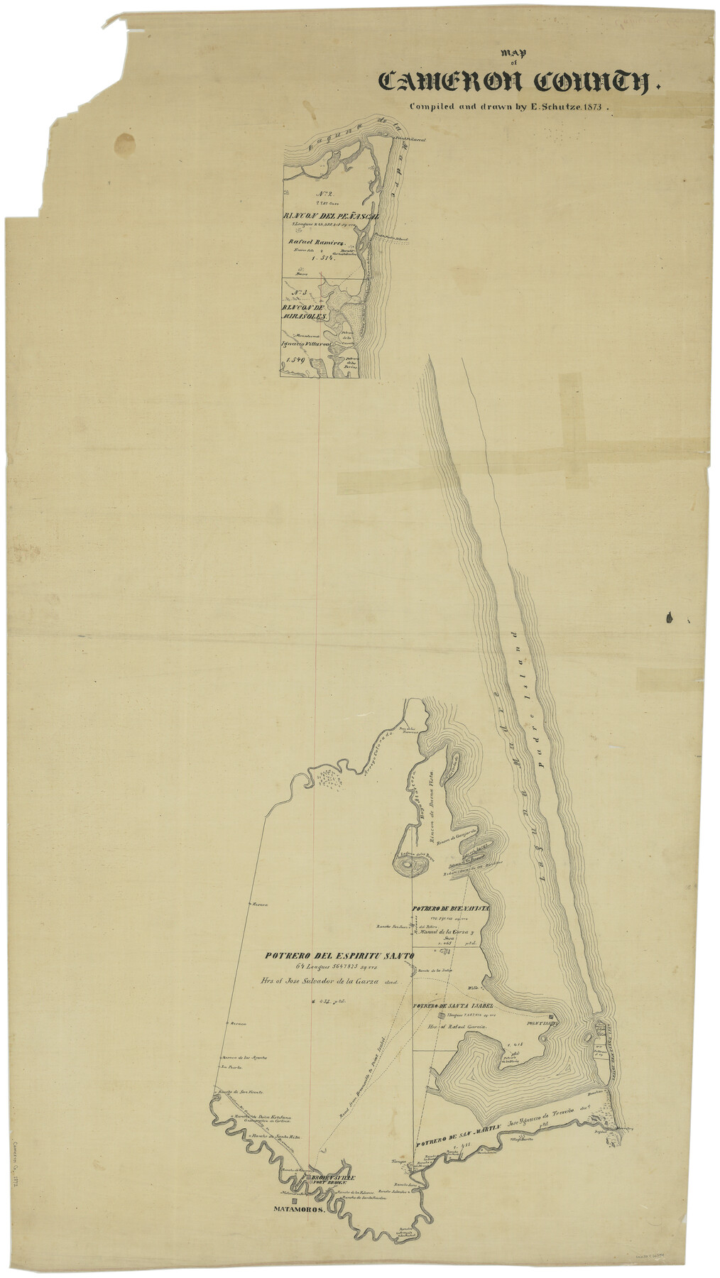
Map of Cameron County
-
Map/Doc
66744
-
Collection
General Map Collection
-
Object Dates
1873 (Creation Date)
-
People and Organizations
Texas General Land Office (Publisher)
Ed. Schutze (Draftsman)
Ed. Schutze (Compiler)
-
Counties
Cameron
-
Subjects
County
-
Height x Width
42.9 x 24.3 inches
109.0 x 61.7 cm
Part of: General Map Collection
Leon County Working Sketch 47

Print $20.00
- Digital $50.00
Leon County Working Sketch 47
1980
Size 29.3 x 25.8 inches
Map/Doc 70446
Kinney County Working Sketch 56

Print $40.00
- Digital $50.00
Kinney County Working Sketch 56
1987
Size 40.5 x 62.8 inches
Map/Doc 70238
Jeff Davis County Rolled Sketch 31

Print $20.00
- Digital $50.00
Jeff Davis County Rolled Sketch 31
1983
Size 40.6 x 44.1 inches
Map/Doc 9268
Edwards County Working Sketch 117

Print $20.00
- Digital $50.00
Edwards County Working Sketch 117
1974
Size 31.4 x 44.1 inches
Map/Doc 68993
Texas Coordinate File 6

Print $40.00
- Digital $50.00
Texas Coordinate File 6
1946
Size 23.7 x 49.0 inches
Map/Doc 75314
Castro County Sketch File 6

Print $20.00
- Digital $50.00
Castro County Sketch File 6
Size 20.8 x 15.6 inches
Map/Doc 11059
Galveston County NRC Article 33.136 Sketch 98

Print $32.00
Galveston County NRC Article 33.136 Sketch 98
2024
Map/Doc 97409
Flight Mission No. CGI-3N, Frame 178, Cameron County

Print $20.00
- Digital $50.00
Flight Mission No. CGI-3N, Frame 178, Cameron County
1954
Size 18.5 x 22.2 inches
Map/Doc 84642
Jefferson County Working Sketch 37

Print $40.00
- Digital $50.00
Jefferson County Working Sketch 37
1982
Size 49.9 x 36.6 inches
Map/Doc 66581
Montgomery Co.

Print $40.00
- Digital $50.00
Montgomery Co.
1943
Size 45.2 x 54.8 inches
Map/Doc 95594
[Galveston, Harrisburg & San Antonio through El Paso County]
![64012, [Galveston, Harrisburg & San Antonio through El Paso County], General Map Collection](https://historictexasmaps.com/wmedia_w700/maps/64012.tif.jpg)
Print $20.00
- Digital $50.00
[Galveston, Harrisburg & San Antonio through El Paso County]
1906
Size 13.6 x 33.8 inches
Map/Doc 64012
Starr County Rolled Sketch 15

Print $20.00
- Digital $50.00
Starr County Rolled Sketch 15
1913
Size 22.7 x 23.6 inches
Map/Doc 7800
You may also like
Topographical Map of the Rio Grande from Roma to the Gulf of Mexico, Index Map, Sheet No. 2

Print $20.00
- Digital $50.00
Topographical Map of the Rio Grande from Roma to the Gulf of Mexico, Index Map, Sheet No. 2
1912
Map/Doc 89524
Ashburn's San Antonio City Map

Ashburn's San Antonio City Map
1951
Size 24.5 x 19.5 inches
Map/Doc 97144
Robertson Co.

Print $20.00
- Digital $50.00
Robertson Co.
1889
Size 43.7 x 39.9 inches
Map/Doc 63003
Burleson County Working Sketch 29

Print $20.00
- Digital $50.00
Burleson County Working Sketch 29
1981
Size 24.7 x 24.7 inches
Map/Doc 67748
Jackson County Working Sketch 3

Print $20.00
- Digital $50.00
Jackson County Working Sketch 3
1941
Size 34.3 x 29.8 inches
Map/Doc 66451
Karnes County Sketch File 10

Print $10.00
- Digital $50.00
Karnes County Sketch File 10
1885
Size 12.8 x 8.5 inches
Map/Doc 28597

Presidio County Working Sketch Graphic Index, South Part, Sheet 2 (Sketches 45 to Most Recent)

Print $20.00
- Digital $50.00
Presidio County Working Sketch Graphic Index, South Part, Sheet 2 (Sketches 45 to Most Recent)
1975
Size 32.4 x 37.9 inches
Map/Doc 76671
Upton County Working Sketch 58

Print $20.00
- Digital $50.00
Upton County Working Sketch 58
1988
Size 29.1 x 37.8 inches
Map/Doc 69555
Duval County Working Sketch 46

Print $20.00
- Digital $50.00
Duval County Working Sketch 46
1980
Size 29.4 x 27.2 inches
Map/Doc 68770
Ward County Sketch File 9

Print $25.00
- Digital $50.00
Ward County Sketch File 9
1937
Size 10.8 x 8.9 inches
Map/Doc 39623
Kenedy County Aerial Photograph Index Sheet 5

Print $20.00
- Digital $50.00
Kenedy County Aerial Photograph Index Sheet 5
1943
Size 23.5 x 19.6 inches
Map/Doc 89046